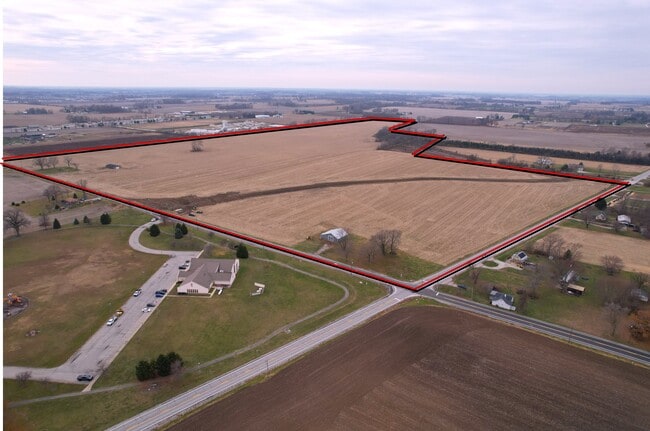
Property Record
13 Sr, Lapel, IN 46051

Save to a Folder
{{folder.Name}}
{{folder.ListingIds.length}} Properties
{{folder.ListingIds.length}} Property
Create a New Folder
This Property Is For Sale
Property Detail
13 Sr
Indianapolis-Carmel-Greenwood, IN
S2 SE 09-18-6 (42.554AC)
48-15-16-500-001.000-044
MADISON
Agriculturalland
Indiana
A Areas with a 1% annual chance of flooding and a 26% chance of flooding over the life of a 30-year mortgage.
79.81 AC
2025
Anderson/Madison Cnty
2025
Indianapolis
011100
NEARBY LISTINGS FOR SALE OR LEASE
DEMOGRAPHICS near 13 Sr
1 mile
3 mile
5 mile
2025 Total Population
137
6,616
26,490
2030 Population
138
7,022
28,165
Pop Growth 2025-2030
+ 0.73%
+ 6.14%
+ 6.32%
Average Age
43
42
40
2025 Total Households
49
2,507
9,539
HH Growth 2025-2030
+ 2.04%
+ 6.46%
+ 6.42%
Median Household Inc
$137,500
$108,669
$113,179
Avg Household Size
2.80
2.60
2.70
2025 Avg HH Vehicles
2.00
2.00
2.00
Median Home Value
$467,499
$313,087
$363,373
Median Year Built
1995
2006
2006
Nearby Places
Map Layers
Map Styles
 Street
 Aerial
Layers
 Traffic
 Biking
Places
Listings with unknown addresses are not visible on the map
- Restaurants
- Banks
- Shops
- Fitness
- Groceries
Nearby Properties
Address
Land Use
TOTAL SIZE
Lot Size
Zoning
Address
Land Use
TOTAL SIZE
Lot Size
Zoning
62,860 SF
19.43 AC
Address
Land Use
TOTAL SIZE
Lot Size
Zoning
20,700 SF
9.93 AC
Address
Land Use
TOTAL SIZE
Lot Size
Zoning
75,740 SF
7.25 AC
Address
Land Use
TOTAL SIZE
Lot Size
Zoning
13,814 SF
17.52 AC
Address
Land Use
TOTAL SIZE
Lot Size
Zoning
10,240 SF
39.51 AC
Address
Land Use
TOTAL SIZE
Lot Size
Zoning
15,021 SF
10 AC
Address
Land Use
TOTAL SIZE
Lot Size
Zoning
18,250 SF
6.38 AC
Address
Land Use
TOTAL SIZE
Lot Size
Zoning
18,557 SF
9.92 AC
Address
Land Use
TOTAL SIZE
Lot Size
Zoning
9,600 SF
13.27 AC
Address
Land Use
TOTAL SIZE
Lot Size
Zoning
1,352 SF
57.81 AC
Address
Land Use
TOTAL SIZE
Lot Size
Zoning
7,452 SF
10.78 AC
Address
Land Use
TOTAL SIZE
Lot Size
Zoning
15,352 SF
3.44 AC
Address
Land Use
TOTAL SIZE
Lot Size
Zoning
8,700 SF
2.93 AC
Address
Land Use
TOTAL SIZE
Lot Size
Zoning
15,520 SF
2.41 AC
Address
Land Use
TOTAL SIZE
Lot Size
Zoning
10,707 SF
14.43 AC
Address
Land Use
TOTAL SIZE
Lot Size
Zoning
5,706 SF
10.16 AC
Address
Land Use
TOTAL SIZE
Lot Size
Zoning
5,880 SF
10.16 AC
Address
Land Use
TOTAL SIZE
Lot Size
Zoning
6,278 SF
4.53 AC
Address
Land Use
TOTAL SIZE
Lot Size
Zoning
5,552 SF
12.23 AC
Address
Land Use
TOTAL SIZE
Lot Size
Zoning
2,322 SF
1.61 AC
Address
Land Use
TOTAL SIZE
Lot Size
Zoning
21.76 AC
Address
Land Use
TOTAL SIZE
Lot Size
Zoning
8,000 SF
40.72 AC
Address
Land Use
TOTAL SIZE
Lot Size
Zoning
7,576 SF
4 AC
Address
Land Use
TOTAL SIZE
Lot Size
Zoning
5,788 SF
52.99 AC
Address
Land Use
TOTAL SIZE
Lot Size
Zoning
7,068 SF
10.81 AC
Address
Land Use
TOTAL SIZE
Lot Size
Zoning
1,444 SF
24.89 AC
Address
Land Use
TOTAL SIZE
Lot Size
Zoning
7,200 SF
3.43 AC
Address
Land Use
TOTAL SIZE
Lot Size
Zoning
20,000 SF
5.42 AC
Address
Land Use
TOTAL SIZE
Lot Size
Zoning
2,698 SF
162.16 AC
Address
Land Use
TOTAL SIZE
Lot Size
Zoning
7,161 SF
10 AC
The World's #1 Commercial Real Estate Marketplace
Connect with us
© 2026 CoStar Group
The information above has been obtained from sources believed reliable. While we do not doubt its accuracy we have not verified it and make no guarantee, warranty or representation about it. It is your responsibility to independently confirm its accuracy and completeness. Any projections, opinions, assumptions, or estimates used are for example only and do not represent the current or future performance of the property. The value of this transaction to you depends on tax and other factors which should be evaluated by your tax, financial, and legal advisors. You and your advisors should conduct a careful, independent investigation of the property to determine to your satisfaction the suitability of the property for your needs.