Property Record
13 The Cir, Georgetown, DE 19947
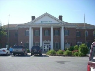

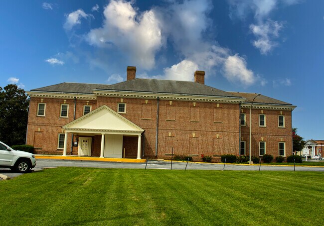
Property Detail
13 The Cir
Seaford, DE
PUBLIC SQUARE LOTS 5 6 39 40
135-19.08-153.00
Sussex
Commercialnec
Delaware
TN
5-6,39
B and X Area of moderate flood hazard, usually the area between the limits of the 100-year and 500-year floods.
0.67 AC
2025
Sussex County
2025
Philadelphia
050505
NEARBY LISTINGS FOR SALE OR LEASE
DEMOGRAPHICS near 13 The Cir
1 mile
3 mile
5 mile
2024 Total Population
6,245
10,440
16,513
2029 Population
6,601
11,082
17,710
Pop Growth 2024-2029
+ 5.70%
+ 6.15%
+ 7.25%
Average Age
37
37
39
2024 Total Households
1,534
2,738
4,892
HH Growth 2024-2029
+ 4.69%
+ 5.37%
+ 6.85%
Median Household Inc
$49,570
$59,596
$69,246
Avg Household Size
3.00
3.00
2.80
2024 Avg HH Vehicles
2.00
2.00
2.00
Median Home Value
$308,633
$302,073
$352,177
Median Year Built
1980
1987
1995
Nearby Places
Map Layers
Map Styles
 Street
 Aerial
Transit
 Traffic
 Biking
Places
Listings with unknown addresses are not visible on the map
- Restaurants
- Banks
- Shops
- Fitness
- Groceries
PUBLIC TRANSPORTATION
AIRPORT
Salisbury-Ocean City Wicomico Regional
Drive
Walk
Distance
Salisbury-Ocean City Wicomico Regional
54 min
33.1 mi
SALE & LEASE HISTORY
LISTING DATE
SALE/LEASE

Dec 19, 2019
For Lease
Nearby Properties
Address
Land Use
TOTAL SIZE
Lot Size
Zoning
Address
Land Use
TOTAL SIZE
Lot Size
Zoning
Address
Land Use
TOTAL SIZE
Lot Size
Zoning
26.04 AC
Address
Land Use
TOTAL SIZE
Lot Size
Zoning
92.30 AC
TN
Address
Land Use
TOTAL SIZE
Lot Size
Zoning
253.48 AC
AR-1
Address
Land Use
TOTAL SIZE
Lot Size
Zoning
24.48 AC
TN
Address
Land Use
TOTAL SIZE
Lot Size
Zoning
35.06 AC
TN
Address
Land Use
TOTAL SIZE
Lot Size
Zoning
2,880 SF
15.83 AC
TN
Address
Land Use
TOTAL SIZE
Lot Size
Zoning
12.82 AC
TN
Address
Land Use
TOTAL SIZE
Lot Size
Zoning
12.38 AC
TN
Address
Land Use
TOTAL SIZE
Lot Size
Zoning
108.19 AC
AR-1
Address
Land Use
TOTAL SIZE
Lot Size
Zoning
191.89 AC
AR-1
Address
Land Use
TOTAL SIZE
Lot Size
Zoning
5.48 AC
TN
Address
Land Use
TOTAL SIZE
Lot Size
Zoning
Address
Land Use
TOTAL SIZE
Lot Size
Zoning
Address
Land Use
TOTAL SIZE
Lot Size
Zoning
638.44 AC
LI-2
Address
Land Use
TOTAL SIZE
Lot Size
Zoning
1,034 SF
54.45 AC
AR-1
Address
Land Use
TOTAL SIZE
Lot Size
Zoning
2,622 SF
0.22 AC
AR-1
Address
Land Use
TOTAL SIZE
Lot Size
Zoning
5.65 AC
TN
Address
Land Use
TOTAL SIZE
Lot Size
Zoning
4.12 AC
TN
Address
Land Use
TOTAL SIZE
Lot Size
Zoning
3,087 SF
0.22 AC
AR-1
Address
Land Use
TOTAL SIZE
Lot Size
Zoning
5,944 SF
260.28 AC
AR-1
Address
Land Use
TOTAL SIZE
Lot Size
Zoning
2,571 SF
0.73 AC
AR-1
Address
Land Use
TOTAL SIZE
Lot Size
Zoning
4.13 AC
TN
Address
Land Use
TOTAL SIZE
Lot Size
Zoning
0.37 AC
TN
Address
Land Use
TOTAL SIZE
Lot Size
Zoning
1,752 SF
2.29 AC
TN
Address
Land Use
TOTAL SIZE
Lot Size
Zoning
2,622 SF
0.52 AC
AR-1
Address
Land Use
TOTAL SIZE
Lot Size
Zoning
22.74 AC
LI-2
Address
Land Use
TOTAL SIZE
Lot Size
Zoning
2,622 SF
0.63 AC
AR-1
The World's #1 Commercial Real Estate Marketplace
Connect with us
© 2026 CoStar Group
The information above has been obtained from sources believed reliable. While we do not doubt its accuracy we have not verified it and make no guarantee, warranty or representation about it. It is your responsibility to independently confirm its accuracy and completeness. Any projections, opinions, assumptions, or estimates used are for example only and do not represent the current or future performance of the property. The value of this transaction to you depends on tax and other factors which should be evaluated by your tax, financial, and legal advisors. You and your advisors should conduct a careful, independent investigation of the property to determine to your satisfaction the suitability of the property for your needs.