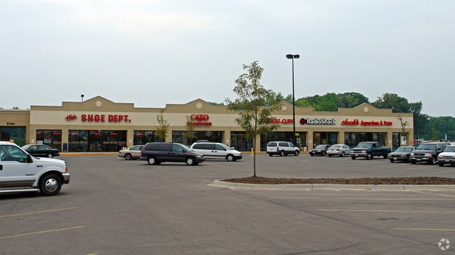
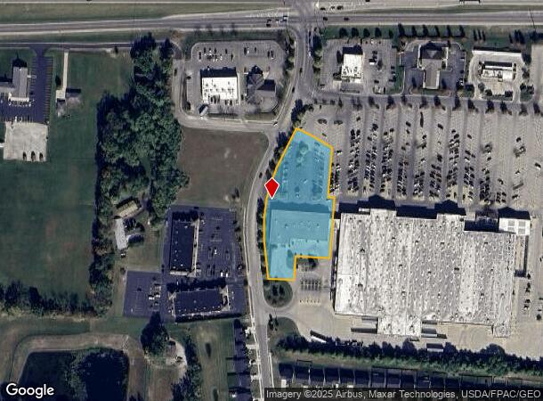
Property Record
120 S Tuttle Rd, Springfield, OH 45505
NEARBY LISTINGS FOR SALE OR LEASE
Property Detail
120 S Tuttle Rd
Springfield, OH
Eastside Square
30-50700-01741-0003
EASTSIDE SQUARE 18969
Storebuilding
Clark
X
Ohio
39023C0211E
3
2023
2.02 AC
2024
Northeast Dayton
001300
Cincinnati/Dayton
17,000 SF
DEMOGRAPHICS near 120 S Tuttle Rd
1 Mile
3 Mile
5 Mile
2024 Total Population
3,778
30,927
77,045
2029 Population
3,775
30,880
76,899
Pop Growth 2024-2029
(0.08%)
(0.15%)
(0.19%)
Average Age
41
39
40
2024 Total Households
1,609
12,886
31,899
HH Growth 2024-2029
(0.12%)
(0.19%)
(0.30%)
Median Household Inc
$62,537
$49,107
$50,081
Avg Household Size
2.30
2.30
2.30
2024 Avg HH Vehicles
2.00
2.00
2.00
Median Home Value
$161,518
$95,602
$126,452
Median Year Built
1961
1950
1956
Nearby Places
Map Layers
Map Styles
 Street
 Aerial
- Restaurants
- Banks
- Shops
- Fitness
- Groceries
PUBLIC TRANSPORTATION
AIRPORT
James M Cox Dayton International
DRIVE
WALK
Distance
James M Cox Dayton International
39 min
30.0 mi
Freight Ports
Port of Toledo
DRIVE
WALK
Distance
Port of Toledo
193 min
133.8 mi
SALE & LEASE HISTORY
LISTING DATE
SALE/LEASE

Oct 02, 2018
For Lease
Nov 30, 2020
For Sale
Aug 20, 2020
For Lease
Nearby Properties
Address
Land Use
TOTAL SIZE
Lot Size
Zoning
Address
Land Use
TOTAL SIZE
Lot Size
Zoning
878,848 SF
115.07 AC
Address
Land Use
TOTAL SIZE
Lot Size
Zoning
399,308 SF
11.06 AC
Address
Land Use
TOTAL SIZE
Lot Size
Zoning
516,191 SF
91.52 AC
A
Address
Land Use
TOTAL SIZE
Lot Size
Zoning
8,316 SF
34.41 AC
R-1
Address
Land Use
TOTAL SIZE
Lot Size
Zoning
386,728 SF
34.66 AC
Address
Land Use
TOTAL SIZE
Lot Size
Zoning
402,733 SF
50.43 AC
Address
Land Use
TOTAL SIZE
Lot Size
Zoning
25.44 AC
Address
Land Use
TOTAL SIZE
Lot Size
Zoning
Address
Land Use
TOTAL SIZE
Lot Size
Zoning
229,125 SF
40.19 AC
Address
Land Use
TOTAL SIZE
Lot Size
Zoning
6,521 SF
94.30 AC
Address
Land Use
TOTAL SIZE
Lot Size
Zoning
199,566 SF
109.96 AC
Address
Land Use
TOTAL SIZE
Lot Size
Zoning
217,626 SF
17.85 AC
Address
Land Use
TOTAL SIZE
Lot Size
Zoning
Address
Land Use
TOTAL SIZE
Lot Size
Zoning
878,588 SF
115.07 AC
Address
Land Use
TOTAL SIZE
Lot Size
Zoning
5.64 AC
Address
Land Use
TOTAL SIZE
Lot Size
Zoning
Address
Land Use
TOTAL SIZE
Lot Size
Zoning
11.42 AC
Address
Land Use
TOTAL SIZE
Lot Size
Zoning
12,657 SF
8.17 AC
Address
Land Use
TOTAL SIZE
Lot Size
Zoning
36,858 SF
17.81 AC
Address
Land Use
TOTAL SIZE
Lot Size
Zoning
20,448 SF
7.35 AC
Address
Land Use
TOTAL SIZE
Lot Size
Zoning
14.83 AC
Address
Land Use
TOTAL SIZE
Lot Size
Zoning
192,651 SF
9.49 AC
Address
Land Use
TOTAL SIZE
Lot Size
Zoning
399,308 SF
11.06 AC
Address
Land Use
TOTAL SIZE
Lot Size
Zoning
Address
Land Use
TOTAL SIZE
Lot Size
Zoning
137,420 SF
5.45 AC
Address
Land Use
TOTAL SIZE
Lot Size
Zoning
55,584 SF
5.97 AC
Address
Land Use
TOTAL SIZE
Lot Size
Zoning
149,240 SF
15.75 AC
Address
Land Use
TOTAL SIZE
Lot Size
Zoning
137,420 SF
5.45 AC
Address
Land Use
TOTAL SIZE
Lot Size
Zoning
3.71 AC
Address
Land Use
TOTAL SIZE
Lot Size
Zoning
6,720 SF
17.36 AC
The World's #1 Commercial Real Estate Marketplace
Connect with us
© 2025 CoStar Group
The information above has been obtained from sources believed reliable. While we do not doubt its accuracy we have not verified it and make no guarantee, warranty or representation about it. It is your responsibility to independently confirm its accuracy and completeness. Any projections, opinions, assumptions, or estimates used are for example only and do not represent the current or future performance of the property. The value of this transaction to you depends on tax and other factors which should be evaluated by your tax, financial, and legal advisors. You and your advisors should conduct a careful, independent investigation of the property to determine to your satisfaction the suitability of the property for your needs.