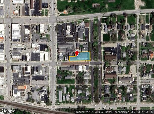
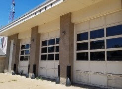
Property Record
130 Adams St, Port Clinton, OH 43452

NEARBY LISTINGS FOR SALE OR LEASE
-
-
View all Port Clinton listings for sale on LoopNet.com
Property Detail
130 Adams St
021-1910626266000
BLOCK 3 LOTS 10 - 11 & 15 EXC E 70' ORGINIAL VAC ALLEY
Officebuilding
Ottawa
X
Ohio
39123C0139D
10-11
2024
0.47 AC
2024
Ottawa County
050500
Toledo
10,080 SF
Port Clinton, OH
DEMOGRAPHICS near 130 Adams St
1 Mile
3 Mile
5 Mile
2024 Total Population
4,452
7,984
9,897
2029 Population
4,321
7,893
9,816
Pop Growth 2024-2029
(2.94%)
(1.14%)
(0.82%)
Average Age
41
43
44
2024 Total Households
1,952
3,568
4,460
HH Growth 2024-2029
(3.53%)
(1.65%)
(1.30%)
Median Household Inc
$51,416
$52,072
$52,137
Avg Household Size
2.20
2.10
2.10
2024 Avg HH Vehicles
2.00
2.00
2.00
Median Home Value
$130,826
$140,339
$148,389
Median Year Built
1954
1964
1968
Nearby Places
Map Layers
Map Styles
 Street
 Aerial
- Restaurants
- Banks
- Shops
- Fitness
- Groceries
SALE & LEASE HISTORY
LISTING DATE
SALE/LEASE

Oct 29, 2018
For Sale
Nov 06, 2019
For Sale
Nearby Properties
Address
Land Use
TOTAL SIZE
Lot Size
Zoning
Address
Land Use
TOTAL SIZE
Lot Size
Zoning
169,534 SF
34.20 AC
Address
Land Use
TOTAL SIZE
Lot Size
Zoning
37,972 SF
4.82 AC
Address
Land Use
TOTAL SIZE
Lot Size
Zoning
104,766 SF
10.06 AC
Address
Land Use
TOTAL SIZE
Lot Size
Zoning
44,359 SF
4.10 AC
Address
Land Use
TOTAL SIZE
Lot Size
Zoning
22,100 SF
18.76 AC
Address
Land Use
TOTAL SIZE
Lot Size
Zoning
7,412 SF
5.21 AC
Address
Land Use
TOTAL SIZE
Lot Size
Zoning
10.64 AC
Address
Land Use
TOTAL SIZE
Lot Size
Zoning
26,996 SF
2.85 AC
Address
Land Use
TOTAL SIZE
Lot Size
Zoning
1,537 SF
28.60 AC
Address
Land Use
TOTAL SIZE
Lot Size
Zoning
52,493 SF
8.26 AC
Address
Land Use
TOTAL SIZE
Lot Size
Zoning
15,722 SF
5 AC
Address
Land Use
TOTAL SIZE
Lot Size
Zoning
7,556 SF
19 AC
Address
Land Use
TOTAL SIZE
Lot Size
Zoning
28,615 SF
4.29 AC
Address
Land Use
TOTAL SIZE
Lot Size
Zoning
Address
Land Use
TOTAL SIZE
Lot Size
Zoning
2,760 SF
42.24 AC
Address
Land Use
TOTAL SIZE
Lot Size
Zoning
53,330 SF
4.90 AC
Address
Land Use
TOTAL SIZE
Lot Size
Zoning
27,380 SF
2.01 AC
Address
Land Use
TOTAL SIZE
Lot Size
Zoning
7,284 SF
3.98 AC
Address
Land Use
TOTAL SIZE
Lot Size
Zoning
25,476 SF
1.03 AC
Address
Land Use
TOTAL SIZE
Lot Size
Zoning
3,320 SF
2.34 AC
Address
Land Use
TOTAL SIZE
Lot Size
Zoning
5,724 SF
6.02 AC
Address
Land Use
TOTAL SIZE
Lot Size
Zoning
10,339 SF
7.62 AC
Address
Land Use
TOTAL SIZE
Lot Size
Zoning
9,286 SF
6.45 AC
Address
Land Use
TOTAL SIZE
Lot Size
Zoning
12,709 SF
1.86 AC
Address
Land Use
TOTAL SIZE
Lot Size
Zoning
12,515 SF
1.19 AC
Address
Land Use
TOTAL SIZE
Lot Size
Zoning
3,438 SF
8.25 AC
Address
Land Use
TOTAL SIZE
Lot Size
Zoning
9,100 SF
1.44 AC
Address
Land Use
TOTAL SIZE
Lot Size
Zoning
28,658 SF
1.91 AC
Address
Land Use
TOTAL SIZE
Lot Size
Zoning
1,408 SF
19.11 AC
Address
Land Use
TOTAL SIZE
Lot Size
Zoning
14,148 SF
1.15 AC
The World's #1 Commercial Real Estate Marketplace
Connect with us
© 2025 CoStar Group
The information above has been obtained from sources believed reliable. While we do not doubt its accuracy we have not verified it and make no guarantee, warranty or representation about it. It is your responsibility to independently confirm its accuracy and completeness. Any projections, opinions, assumptions, or estimates used are for example only and do not represent the current or future performance of the property. The value of this transaction to you depends on tax and other factors which should be evaluated by your tax, financial, and legal advisors. You and your advisors should conduct a careful, independent investigation of the property to determine to your satisfaction the suitability of the property for your needs.