Property Record
130 Alligator Rd, Lafayette, LA 70508
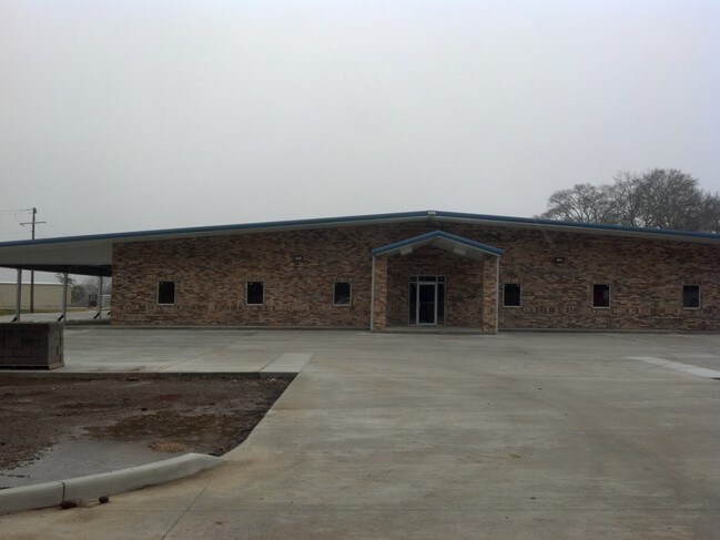


Property Detail
130 Alligator Rd
6137023
TR 5 6-A-1 SEC 43 T10S R5E (13.789 AC) (2014-20544 PLAT)
Warehouse
LAFAYETTE
AE The base floodplain where base flood elevations are provided. AE Zones are now used on new format FIRMs instead of A1-A30 Zones.
Louisiana
2025
13.79 AC
2025
Greater Lafayette
001421
Lafayette
8,056 SF
Lafayette, LA
NEARBY LISTINGS FOR SALE OR LEASE
DEMOGRAPHICS near 130 Alligator Rd
1 mile
3 mile
5 mile
2025 Total Population
641
36,656
122,776
2030 Population
662
38,405
128,297
Pop Growth 2025-2030
+ 3.28%
+ 4.77%
+ 4.50%
Average Age
40
40
40
2025 Total Households
280
16,648
52,518
HH Growth 2025-2030
+ 3.21%
+ 4.93%
+ 4.60%
Median Household Inc
$54,897
$58,519
$58,174
Avg Household Size
2.30
2.10
2.20
2025 Avg HH Vehicles
2.00
2.00
2.00
Median Home Value
$251,999
$279,136
$257,922
Median Year Built
1995
1982
1981
Nearby Places
Map Layers
Map Styles
 Street
 Aerial
Layers
 Traffic
 Biking
Places
Listings with unknown addresses are not visible on the map
- Restaurants
- Banks
- Shops
- Fitness
- Groceries
PUBLIC TRANSPORTATION
COMMUTER RAIL
Lafayette Amtrak Station (Sunset Limited - Amtrak)
Drive
Walk
Distance
Lafayette Amtrak Station (Sunset Limited - Amtrak)
6 min
3.4 mi
AIRPORT
Lafayette Regional/Paul Fournet Field
Drive
Walk
Distance
Lafayette Regional/Paul Fournet Field
4 min
2.4 mi
Freight Ports
Port of Iberia
Drive
Walk
Distance
Port of Iberia
26 min
20.6 mi
Nearby Properties
Address
Land Use
TOTAL SIZE
Lot Size
Zoning
Address
Land Use
TOTAL SIZE
Lot Size
Zoning
800,608 SF
6.64 AC
Address
Land Use
TOTAL SIZE
Lot Size
Zoning
82,329 SF
1 AC
Address
Land Use
TOTAL SIZE
Lot Size
Zoning
51,132 SF
11.07 AC
Address
Land Use
TOTAL SIZE
Lot Size
Zoning
273,165 SF
15.14 AC
Address
Land Use
TOTAL SIZE
Lot Size
Zoning
141,706 SF
3.44 AC
Address
Land Use
TOTAL SIZE
Lot Size
Zoning
70,972 SF
921.26 AC
Address
Land Use
TOTAL SIZE
Lot Size
Zoning
273,675 SF
6.38 AC
Address
Land Use
TOTAL SIZE
Lot Size
Zoning
20,775 SF
11.04 AC
Address
Land Use
TOTAL SIZE
Lot Size
Zoning
158,272 SF
Address
Land Use
TOTAL SIZE
Lot Size
Zoning
145,412 SF
0.01 AC
Address
Land Use
TOTAL SIZE
Lot Size
Zoning
221,760 SF
0.67 AC
Address
Land Use
TOTAL SIZE
Lot Size
Zoning
67,949 SF
0.92 AC
Address
Land Use
TOTAL SIZE
Lot Size
Zoning
11,778 SF
15.25 AC
Address
Land Use
TOTAL SIZE
Lot Size
Zoning
98,973 SF
9.91 AC
Address
Land Use
TOTAL SIZE
Lot Size
Zoning
900 SF
12.41 AC
Address
Land Use
TOTAL SIZE
Lot Size
Zoning
92,556 SF
10.75 AC
Address
Land Use
TOTAL SIZE
Lot Size
Zoning
47,960 SF
3.97 AC
Address
Land Use
TOTAL SIZE
Lot Size
Zoning
84,225 SF
Address
Land Use
TOTAL SIZE
Lot Size
Zoning
194,912 SF
13.73 AC
Address
Land Use
TOTAL SIZE
Lot Size
Zoning
74,343 SF
8.88 AC
Address
Land Use
TOTAL SIZE
Lot Size
Zoning
106,686 SF
7.03 AC
Address
Land Use
TOTAL SIZE
Lot Size
Zoning
151,863 SF
1.43 AC
Address
Land Use
TOTAL SIZE
Lot Size
Zoning
205,096 SF
21.71 AC
Address
Land Use
TOTAL SIZE
Lot Size
Zoning
61,913 SF
10 AC
Address
Land Use
TOTAL SIZE
Lot Size
Zoning
87,868 SF
3.02 AC
Address
Land Use
TOTAL SIZE
Lot Size
Zoning
120,500 SF
20 AC
Address
Land Use
TOTAL SIZE
Lot Size
Zoning
77,245 SF
24.08 AC
Address
Land Use
TOTAL SIZE
Lot Size
Zoning
83,756 SF
Address
Land Use
TOTAL SIZE
Lot Size
Zoning
150,000 SF
1 AC
Address
Land Use
TOTAL SIZE
Lot Size
Zoning
5,625 SF
25.86 AC
The World's #1 Commercial Real Estate Marketplace
Connect with us
© 2026 CoStar Group
The information above has been obtained from sources believed reliable. While we do not doubt its accuracy we have not verified it and make no guarantee, warranty or representation about it. It is your responsibility to independently confirm its accuracy and completeness. Any projections, opinions, assumptions, or estimates used are for example only and do not represent the current or future performance of the property. The value of this transaction to you depends on tax and other factors which should be evaluated by your tax, financial, and legal advisors. You and your advisors should conduct a careful, independent investigation of the property to determine to your satisfaction the suitability of the property for your needs.