Property Record
130 E Broussard Rd, Lafayette, LA 70503

Property Detail
130 E Broussard Rd
Lafayette, LA
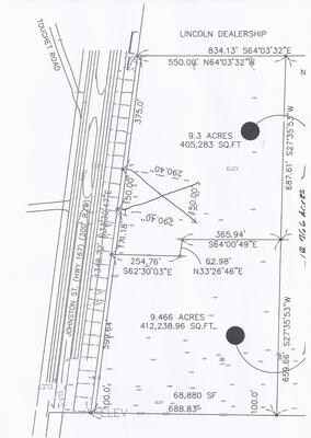
14.28 ACRES-(LOT 2A)-FRONTING ON E BROUSSARD RD-SECS 76/79 T10S R4E (815.57X342.82X386.75X342.28X72.53
6091594
LAFAYETTE
Commercialacreage
Louisiana
B and X Area of moderate flood hazard, usually the area between the limits of the 100-year and 500-year floods.
2a
2025
14.28 AC
2025
Outlying Lafayette Parish
001413
Lafayette
NEARBY LISTINGS FOR SALE OR LEASE
-
-
-
No Photo
-
View all Lafayette listings for sale on LoopNet.com
DEMOGRAPHICS near 130 E Broussard Rd
1 mile
3 mile
5 mile
2025 Total Population
5,001
32,642
98,855
2030 Population
5,199
34,101
103,048
Pop Growth 2025-2030
+ 3.96%
+ 4.47%
+ 4.24%
Average Age
38
39
40
2025 Total Households
1,773
12,884
40,931
HH Growth 2025-2030
+ 4.00%
+ 4.56%
+ 4.31%
Median Household Inc
$99,999
$86,552
$77,646
Avg Household Size
2.70
2.40
2.30
2025 Avg HH Vehicles
2.00
2.00
2.00
Median Home Value
$377,111
$317,892
$278,464
Median Year Built
1989
1996
1990
Nearby Places
Map Layers
Map Styles
 Street
 Aerial
Transit
 Traffic
 Biking
Places
Listings with unknown addresses are not visible on the map
- Restaurants
- Banks
- Shops
- Fitness
- Groceries
PUBLIC TRANSPORTATION
COMMUTER RAIL
Lafayette Amtrak Station (Sunset Limited - Amtrak)
Drive
Walk
Distance
Lafayette Amtrak Station (Sunset Limited - Amtrak)
14 min
7.6 mi
AIRPORT
Lafayette Regional/Paul Fournet Field
Drive
Walk
Distance
Lafayette Regional/Paul Fournet Field
18 min
9.5 mi
Freight Ports
Port of Iberia
Drive
Walk
Distance
Port of Iberia
37 min
25.3 mi
Nearby Properties
Address
Land Use
TOTAL SIZE
Lot Size
Zoning
Address
Land Use
TOTAL SIZE
Lot Size
Zoning
18.28 AC
Address
Land Use
TOTAL SIZE
Lot Size
Zoning
13,069 SF
23.27 AC
Address
Land Use
TOTAL SIZE
Lot Size
Zoning
200,000 SF
Address
Land Use
TOTAL SIZE
Lot Size
Zoning
23,377 SF
14.53 AC
Address
Land Use
TOTAL SIZE
Lot Size
Zoning
4,632 SF
14.48 AC
Address
Land Use
TOTAL SIZE
Lot Size
Zoning
7,366 SF
11.92 AC
Address
Land Use
TOTAL SIZE
Lot Size
Zoning
7,354 SF
11.09 AC
Address
Land Use
TOTAL SIZE
Lot Size
Zoning
Address
Land Use
TOTAL SIZE
Lot Size
Zoning
403,466 SF
27.66 AC
Address
Land Use
TOTAL SIZE
Lot Size
Zoning
Address
Land Use
TOTAL SIZE
Lot Size
Zoning
12,372 SF
10 AC
Address
Land Use
TOTAL SIZE
Lot Size
Zoning
12,291 SF
0.02 AC
Address
Land Use
TOTAL SIZE
Lot Size
Zoning
114,843 SF
12.64 AC
Address
Land Use
TOTAL SIZE
Lot Size
Zoning
226,513 SF
0.02 AC
Address
Land Use
TOTAL SIZE
Lot Size
Zoning
173,563 SF
19.13 AC
Address
Land Use
TOTAL SIZE
Lot Size
Zoning
180,132 SF
18.18 AC
Address
Land Use
TOTAL SIZE
Lot Size
Zoning
11,768 SF
11.29 AC
Address
Land Use
TOTAL SIZE
Lot Size
Zoning
93,184 SF
0.02 AC
Address
Land Use
TOTAL SIZE
Lot Size
Zoning
134,557 SF
5.48 AC
Address
Land Use
TOTAL SIZE
Lot Size
Zoning
156,047 SF
8.89 AC
Address
Land Use
TOTAL SIZE
Lot Size
Zoning
146,450 SF
0.02 AC
Address
Land Use
TOTAL SIZE
Lot Size
Zoning
103,776 SF
11.54 AC
Address
Land Use
TOTAL SIZE
Lot Size
Zoning
197,500 SF
16.83 AC
Address
Land Use
TOTAL SIZE
Lot Size
Zoning
237,406 SF
0.02 AC
Address
Land Use
TOTAL SIZE
Lot Size
Zoning
139,638 SF
14.33 AC
Address
Land Use
TOTAL SIZE
Lot Size
Zoning
35,212 SF
6.58 AC
Address
Land Use
TOTAL SIZE
Lot Size
Zoning
112,082 SF
0.02 AC
Address
Land Use
TOTAL SIZE
Lot Size
Zoning
89,864 SF
3.73 AC
Address
Land Use
TOTAL SIZE
Lot Size
Zoning
107,576 SF
11.58 AC
Address
Land Use
TOTAL SIZE
Lot Size
Zoning
24,643 SF
23.26 AC
The World's #1 Commercial Real Estate Marketplace
Connect with us
© 2026 CoStar Group
The information above has been obtained from sources believed reliable. While we do not doubt its accuracy we have not verified it and make no guarantee, warranty or representation about it. It is your responsibility to independently confirm its accuracy and completeness. Any projections, opinions, assumptions, or estimates used are for example only and do not represent the current or future performance of the property. The value of this transaction to you depends on tax and other factors which should be evaluated by your tax, financial, and legal advisors. You and your advisors should conduct a careful, independent investigation of the property to determine to your satisfaction the suitability of the property for your needs.