Property Record
130 Edwards Cir, Flora, MS 39071


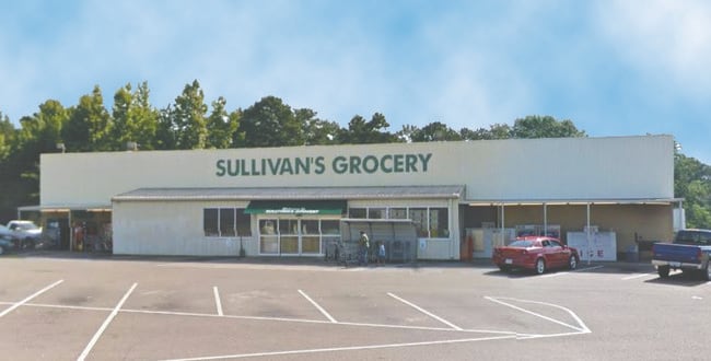
Property Detail
130 Edwards Cir
051C-08C-009-02-00
1.45AC IN NE COR NE1/4 SW1/4
Supermarket
Madison
B and X Area of moderate flood hazard, usually the area between the limits of the 100-year and 500-year floods.
Mississippi
2025
1.45 AC
2025
Outlying Madison County
030302
Jackson
17,274 SF
Jackson, MS
NEARBY LISTINGS FOR SALE OR LEASE
-
-
View all Flora listings for sale on LoopNet.com
DEMOGRAPHICS near 130 Edwards Cir
1 mile
3 mile
5 mile
2025 Total Population
967
2,629
4,194
2030 Population
990
2,686
4,283
Pop Growth 2025-2030
+ 2.38%
+ 2.17%
+ 2.12%
Average Age
43
41
41
2025 Total Households
415
1,067
1,684
HH Growth 2025-2030
+ 2.65%
+ 2.44%
+ 2.43%
Median Household Inc
$70,874
$50,357
$49,122
Avg Household Size
2.30
2.40
2.40
2025 Avg HH Vehicles
2.00
2.00
2.00
Median Home Value
$315,625
$379,285
$392,034
Median Year Built
1978
1977
1977
Nearby Places
Map Layers
Map Styles
 Street
 Aerial
Layers
 Traffic
 Biking
Places
Listings with unknown addresses are not visible on the map
- Restaurants
- Banks
- Shops
- Fitness
- Groceries
PUBLIC TRANSPORTATION
AIRPORT
Jackson-Medgar Wiley Evers International
Drive
Walk
Distance
Jackson-Medgar Wiley Evers International
46 min
34.0 mi
Freight Ports
Port of Greater Baton Rouge
Drive
Walk
Distance
Port of Greater Baton Rouge
221 min
196.3 mi
Nearby Properties
Address
Land Use
TOTAL SIZE
Lot Size
Zoning
Address
Land Use
TOTAL SIZE
Lot Size
Zoning
3,931 SF
7.21 AC
A1
Address
Land Use
TOTAL SIZE
Lot Size
Zoning
63,000 SF
1.45 AC
Address
Land Use
TOTAL SIZE
Lot Size
Zoning
2,670 SF
3.40 AC
Address
Land Use
TOTAL SIZE
Lot Size
Zoning
19,677 SF
3.50 AC
Address
Land Use
TOTAL SIZE
Lot Size
Zoning
37,595 SF
3.50 AC
Address
Land Use
TOTAL SIZE
Lot Size
Zoning
10,336 SF
6.40 AC
Address
Land Use
TOTAL SIZE
Lot Size
Zoning
6,256 SF
4.07 AC
Address
Land Use
TOTAL SIZE
Lot Size
Zoning
3,206 SF
0.50 AC
Address
Land Use
TOTAL SIZE
Lot Size
Zoning
68,952 SF
6.60 AC
Address
Land Use
TOTAL SIZE
Lot Size
Zoning
5,839 SF
1.50 AC
Address
Land Use
TOTAL SIZE
Lot Size
Zoning
3,900 SF
4.50 AC
Address
Land Use
TOTAL SIZE
Lot Size
Zoning
19,002 SF
3.34 AC
Address
Land Use
TOTAL SIZE
Lot Size
Zoning
3,696 SF
1.70 AC
Address
Land Use
TOTAL SIZE
Lot Size
Zoning
16,547 SF
1.29 AC
Address
Land Use
TOTAL SIZE
Lot Size
Zoning
10,768 SF
0.41 AC
Address
Land Use
TOTAL SIZE
Lot Size
Zoning
18,224 SF
3 AC
Address
Land Use
TOTAL SIZE
Lot Size
Zoning
4,270 SF
14.44 AC
Address
Land Use
TOTAL SIZE
Lot Size
Zoning
3,854 SF
1.18 AC
Address
Land Use
TOTAL SIZE
Lot Size
Zoning
4,090 SF
5.80 AC
R1
Address
Land Use
TOTAL SIZE
Lot Size
Zoning
3,199 SF
0.92 AC
Address
Land Use
TOTAL SIZE
Lot Size
Zoning
5,000 SF
1 AC
Address
Land Use
TOTAL SIZE
Lot Size
Zoning
5,443 SF
0.14 AC
Address
Land Use
TOTAL SIZE
Lot Size
Zoning
4,660 SF
2.01 AC
Address
Land Use
TOTAL SIZE
Lot Size
Zoning
4,972 SF
45.20 AC
Address
Land Use
TOTAL SIZE
Lot Size
Zoning
4,852 SF
12 AC
A1
Address
Land Use
TOTAL SIZE
Lot Size
Zoning
10,348 SF
1.11 AC
Address
Land Use
TOTAL SIZE
Lot Size
Zoning
4,792 SF
8.57 AC
R1
The World's #1 Commercial Real Estate Marketplace
Connect with us
© 2026 CoStar Group
The information above has been obtained from sources believed reliable. While we do not doubt its accuracy we have not verified it and make no guarantee, warranty or representation about it. It is your responsibility to independently confirm its accuracy and completeness. Any projections, opinions, assumptions, or estimates used are for example only and do not represent the current or future performance of the property. The value of this transaction to you depends on tax and other factors which should be evaluated by your tax, financial, and legal advisors. You and your advisors should conduct a careful, independent investigation of the property to determine to your satisfaction the suitability of the property for your needs.