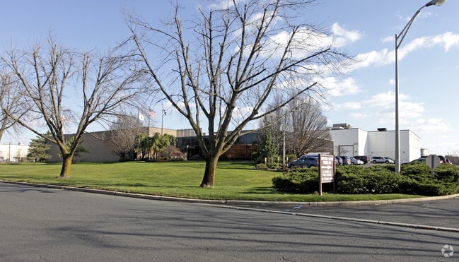
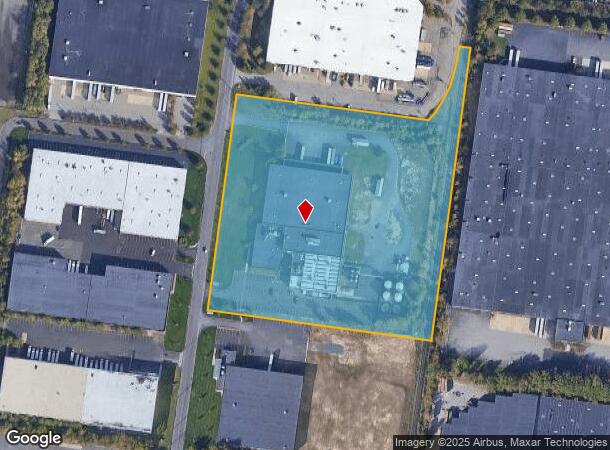
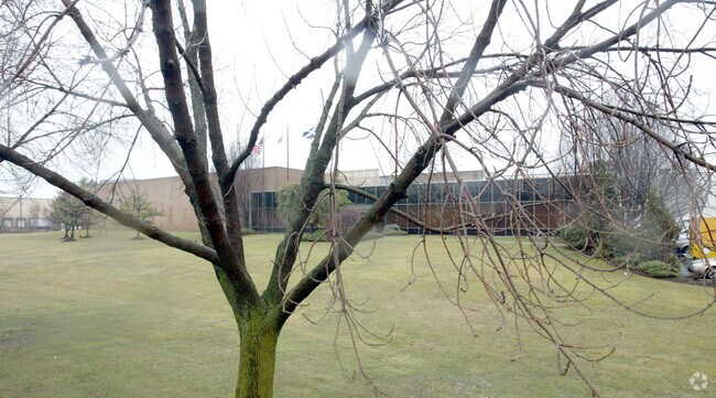
Property Record
130 Fieldcrest Ave, Edison, NJ 08837
NEARBY LISTINGS FOR SALE OR LEASE
Property Detail
130 Fieldcrest Ave
New York-Jersey City-White Plains, NY-NJ
10.286 AC
05-00390-04-00010-01
Middlesex
Industrialgeneral
New Jersey
X
10.1
34023C0063F
10.29 AC
2024
Exit 10
2025
Northern New Jersey
001806
DEMOGRAPHICS near 130 Fieldcrest Ave
1 Mile
3 Mile
5 Mile
2024 Total Population
2,839
78,241
301,425
2029 Population
2,828
77,723
298,337
Pop Growth 2024-2029
(0.39%)
(0.66%)
(1.02%)
Average Age
40
41
40
2024 Total Households
994
28,812
105,320
HH Growth 2024-2029
(0.40%)
(0.75%)
(1.04%)
Median Household Inc
$136,014
$102,833
$98,065
Avg Household Size
2.70
2.60
2.80
2024 Avg HH Vehicles
2.00
2.00
2.00
Median Home Value
$497,142
$383,475
$384,927
Median Year Built
1985
1963
1965
Nearby Places
Map Layers
Map Styles
 Street
 Aerial
- Restaurants
- Banks
- Shops
- Fitness
- Groceries
PUBLIC TRANSPORTATION
COMMUTER RAIL
Metuchen (Northeast Corridor Line - NJ Transit Commuter Rail (NJ Transit))
DRIVE
WALK
Distance
Metuchen (Northeast Corridor Line - NJ Transit Commuter Rail (NJ Transit))
9 min
3.5 mi
Perth Amboy (North Jersey Coast Line - NJ Transit Commuter Rail (NJ Transit))
DRIVE
WALK
Distance
Perth Amboy (North Jersey Coast Line - NJ Transit Commuter Rail (NJ Transit))
10 min
4.8 mi
AIRPORT
Newark Liberty International
DRIVE
WALK
Distance
Newark Liberty International
32 min
22.7 mi
Trenton Mercer
DRIVE
WALK
Distance
Trenton Mercer
52 min
34.7 mi
LaGuardia
DRIVE
WALK
Distance
LaGuardia
61 min
39.3 mi
Freight Ports
New York Container Terminal
DRIVE
WALK
Distance
New York Container Terminal
24 min
16.3 mi
Nearby Properties
Address
Land Use
TOTAL SIZE
Lot Size
Zoning
Address
Land Use
TOTAL SIZE
Lot Size
Zoning
1,889 SF
235.62 AC
Address
Land Use
TOTAL SIZE
Lot Size
Zoning
37.46 AC
EI
Address
Land Use
TOTAL SIZE
Lot Size
Zoning
65.84 AC
PB
Address
Land Use
TOTAL SIZE
Lot Size
Zoning
165.43 AC
EI
Address
Land Use
TOTAL SIZE
Lot Size
Zoning
147.45 AC
RRRD
Address
Land Use
TOTAL SIZE
Lot Size
Zoning
49.83 AC
LI
Address
Land Use
TOTAL SIZE
Lot Size
Zoning
55.57 AC
LI
Address
Land Use
TOTAL SIZE
Lot Size
Zoning
40.78 AC
RRRD
Address
Land Use
TOTAL SIZE
Lot Size
Zoning
35.98 AC
LI
Address
Land Use
TOTAL SIZE
Lot Size
Zoning
27.36 AC
Address
Land Use
TOTAL SIZE
Lot Size
Zoning
34.14 AC
LR
Address
Land Use
TOTAL SIZE
Lot Size
Zoning
3.18 AC
Address
Land Use
TOTAL SIZE
Lot Size
Zoning
162.66 AC
LI
Address
Land Use
TOTAL SIZE
Lot Size
Zoning
58.78 AC
LI
Address
Land Use
TOTAL SIZE
Lot Size
Zoning
53.95 AC
RRRD
Address
Land Use
TOTAL SIZE
Lot Size
Zoning
90.33 AC
Address
Land Use
TOTAL SIZE
Lot Size
Zoning
164.79 AC
LI
Address
Land Use
TOTAL SIZE
Lot Size
Zoning
52.04 AC
RRRD
Address
Land Use
TOTAL SIZE
Lot Size
Zoning
34.63 AC
LR
Address
Land Use
TOTAL SIZE
Lot Size
Zoning
Address
Land Use
TOTAL SIZE
Lot Size
Zoning
52.80 AC
LI
Address
Land Use
TOTAL SIZE
Lot Size
Zoning
43.63 AC
MF
Address
Land Use
TOTAL SIZE
Lot Size
Zoning
41.20 AC
RRRD
Address
Land Use
TOTAL SIZE
Lot Size
Zoning
50 AC
LI
Address
Land Use
TOTAL SIZE
Lot Size
Zoning
22.50 AC
LR
Address
Land Use
TOTAL SIZE
Lot Size
Zoning
89.43 AC
LI
Address
Land Use
TOTAL SIZE
Lot Size
Zoning
26.50 AC
LR
Address
Land Use
TOTAL SIZE
Lot Size
Zoning
20.81 AC
GBH
Address
Land Use
TOTAL SIZE
Lot Size
Zoning
25.82 AC
RRRD
Address
Land Use
TOTAL SIZE
Lot Size
Zoning
16.79 AC
GBH
The World's #1 Commercial Real Estate Marketplace
Connect with us
© 2025 CoStar Group
The information above has been obtained from sources believed reliable. While we do not doubt its accuracy we have not verified it and make no guarantee, warranty or representation about it. It is your responsibility to independently confirm its accuracy and completeness. Any projections, opinions, assumptions, or estimates used are for example only and do not represent the current or future performance of the property. The value of this transaction to you depends on tax and other factors which should be evaluated by your tax, financial, and legal advisors. You and your advisors should conduct a careful, independent investigation of the property to determine to your satisfaction the suitability of the property for your needs.