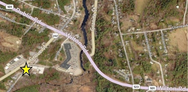
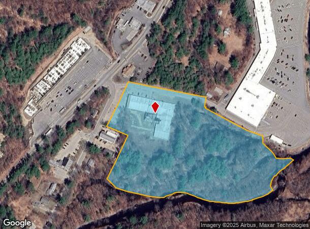
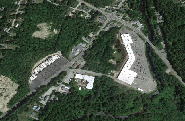
Property Record
130 Grove St, Peterborough, NH 03458
NEARBY LISTINGS FOR SALE OR LEASE
-
-
View all Peterborough listings for sale on LoopNet.com
Property Detail
130 Grove St
PTBR-000021U-000008
Hillsborough
Industrialgeneral
New Hampshire
AE
10.80 AC
33011C0402D
Hillsborough
2024
Boston
2024
Manchester-Nashua, NH
023001
DEMOGRAPHICS near 130 Grove St
1 Mile
3 Mile
5 Mile
2024 Total Population
2,523
5,774
10,248
2029 Population
2,616
5,943
10,580
Pop Growth 2024-2029
+ 3.69%
+ 2.93%
+ 3.24%
Average Age
48
47
46
2024 Total Households
1,121
2,503
4,346
HH Growth 2024-2029
+ 3.84%
+ 2.96%
+ 3.18%
Median Household Inc
$123,610
$107,677
$94,179
Avg Household Size
2.10
2.20
2.30
2024 Avg HH Vehicles
2.00
2.00
2.00
Median Home Value
$395,587
$380,990
$328,257
Median Year Built
1963
1966
1971
Nearby Places
Map Layers
Map Styles
 Street
 Aerial
- Restaurants
- Banks
- Shops
- Fitness
- Groceries
PUBLIC TRANSPORTATION
AIRPORT
Manchester Boston Regional
DRIVE
WALK
Distance
Manchester Boston Regional
64 min
36.9 mi
Freight Ports
Port of Boston
DRIVE
WALK
Distance
Port of Boston
116 min
77.8 mi
SALE & LEASE HISTORY
LISTING DATE
SALE/LEASE

Mar 09, 2022
For Sale
Nearby Properties
Address
Land Use
TOTAL SIZE
Lot Size
Zoning
Address
Land Use
TOTAL SIZE
Lot Size
Zoning
30 AC
FAMILY
Address
Land Use
TOTAL SIZE
Lot Size
Zoning
33.12 AC
R
Address
Land Use
TOTAL SIZE
Lot Size
Zoning
55.90 AC
RET C
Address
Land Use
TOTAL SIZE
Lot Size
Zoning
24.24 AC
R
Address
Land Use
TOTAL SIZE
Lot Size
Zoning
369.99 AC
R
Address
Land Use
TOTAL SIZE
Lot Size
Zoning
14.09 AC
FAMILY
Address
Land Use
TOTAL SIZE
Lot Size
Zoning
10.42 AC
COMMER
Address
Land Use
TOTAL SIZE
Lot Size
Zoning
331.37 AC
FAMILY
Address
Land Use
TOTAL SIZE
Lot Size
Zoning
25.40 AC
INDUST
Address
Land Use
TOTAL SIZE
Lot Size
Zoning
3.35 AC
GEN.RE
Address
Land Use
TOTAL SIZE
Lot Size
Zoning
5.21 AC
COMMER
Address
Land Use
TOTAL SIZE
Lot Size
Zoning
8.31 AC
GEN.RE
Address
Land Use
TOTAL SIZE
Lot Size
Zoning
7.50 AC
GEN.RE
Address
Land Use
TOTAL SIZE
Lot Size
Zoning
3.30 AC
GEN.RE
Address
Land Use
TOTAL SIZE
Lot Size
Zoning
167.21 AC
FAMILY
Address
Land Use
TOTAL SIZE
Lot Size
Zoning
2 AC
COMMER
Address
Land Use
TOTAL SIZE
Lot Size
Zoning
0.29 AC
COMMER
Address
Land Use
TOTAL SIZE
Lot Size
Zoning
5.71 AC
COMMER
Address
Land Use
TOTAL SIZE
Lot Size
Zoning
1.76 AC
COMMER
Address
Land Use
TOTAL SIZE
Lot Size
Zoning
1.45 AC
GEN.RE
Address
Land Use
TOTAL SIZE
Lot Size
Zoning
3.81 AC
COMMER
Address
Land Use
TOTAL SIZE
Lot Size
Zoning
41.36 AC
R
Address
Land Use
TOTAL SIZE
Lot Size
Zoning
4.73 AC
I
Address
Land Use
TOTAL SIZE
Lot Size
Zoning
1.04 AC
COMMER
Address
Land Use
TOTAL SIZE
Lot Size
Zoning
0.79 AC
COMMER
Address
Land Use
TOTAL SIZE
Lot Size
Zoning
Address
Land Use
TOTAL SIZE
Lot Size
Zoning
14.27 AC
GEN.RE
Address
Land Use
TOTAL SIZE
Lot Size
Zoning
0.70 AC
GEN.RE
Address
Land Use
TOTAL SIZE
Lot Size
Zoning
4.66 AC
GEN.RE
Address
Land Use
TOTAL SIZE
Lot Size
Zoning
47.40 AC
R
The World's #1 Commercial Real Estate Marketplace
Connect with us
© 2026 CoStar Group
The information above has been obtained from sources believed reliable. While we do not doubt its accuracy we have not verified it and make no guarantee, warranty or representation about it. It is your responsibility to independently confirm its accuracy and completeness. Any projections, opinions, assumptions, or estimates used are for example only and do not represent the current or future performance of the property. The value of this transaction to you depends on tax and other factors which should be evaluated by your tax, financial, and legal advisors. You and your advisors should conduct a careful, independent investigation of the property to determine to your satisfaction the suitability of the property for your needs.