Property Record
130 Highway 339, Mason Valley, NV 89447

NEARBY LISTINGS FOR SALE OR LEASE
Property Detail
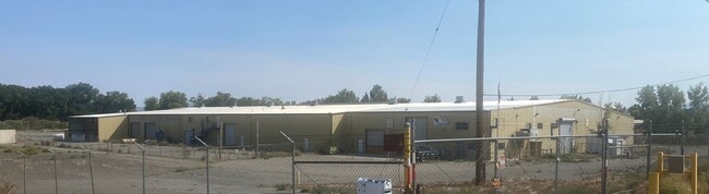
130 Highway 339
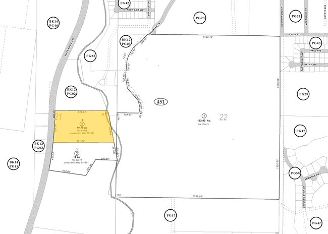
012-021-05
Parcel Map For Navada West Packing
Lightindustrial
PAR 2
X
Lyon
32019C0856E
Nevada
2026
10.72 AC
2025
S Lyon County
960802
Reno/Sparks
51,504 SF
Fernley, NV
DEMOGRAPHICS near 130 Highway 339
1 Mile
3 Mile
5 Mile
2024 Total Population
1,114
6,586
7,517
2029 Population
1,261
7,401
8,437
Pop Growth 2024-2029
+ 13.20%
+ 12.37%
+ 12.24%
Average Age
45
44
44
2024 Total Households
476
2,782
3,157
HH Growth 2024-2029
+ 13.45%
+ 12.47%
+ 12.39%
Median Household Inc
$41,052
$38,175
$38,799
Avg Household Size
2.30
2.30
2.30
2024 Avg HH Vehicles
2.00
2.00
2.00
Median Home Value
$277,777
$255,109
$257,734
Median Year Built
1983
1982
1982
Nearby Places
Map Layers
Map Styles
 Street
 Aerial
- Restaurants
- Banks
- Shops
- Fitness
- Groceries
SALE & LEASE HISTORY
LISTING DATE
SALE/LEASE

Oct 04, 2021
For Sale
Nearby Properties
Address
Land Use
TOTAL SIZE
Lot Size
Zoning
Address
Land Use
TOTAL SIZE
Lot Size
Zoning
4,080 SF
7.89 AC
M1
Address
Land Use
TOTAL SIZE
Lot Size
Zoning
19,680 SF
53 AC
MULT
Address
Land Use
TOTAL SIZE
Lot Size
Zoning
71,814 SF
11.49 AC
M1
Address
Land Use
TOTAL SIZE
Lot Size
Zoning
2,669 SF
164.88 AC
MULT
Address
Land Use
TOTAL SIZE
Lot Size
Zoning
84,078 SF
22.52 AC
MULT
Address
Land Use
TOTAL SIZE
Lot Size
Zoning
43,449 SF
19.33 AC
RC
Address
Land Use
TOTAL SIZE
Lot Size
Zoning
1,548 SF
219.20 AC
M1
Address
Land Use
TOTAL SIZE
Lot Size
Zoning
45,108 SF
6.77 AC
HZ
Address
Land Use
TOTAL SIZE
Lot Size
Zoning
42,700 SF
10.96 AC
M1
Address
Land Use
TOTAL SIZE
Lot Size
Zoning
41,274 SF
4.91 AC
C1
Address
Land Use
TOTAL SIZE
Lot Size
Zoning
8,639 SF
5.15 AC
RC
Address
Land Use
TOTAL SIZE
Lot Size
Zoning
35,200 SF
10.22 AC
M1
Address
Land Use
TOTAL SIZE
Lot Size
Zoning
1,964 SF
12 AC
MULT
Address
Land Use
TOTAL SIZE
Lot Size
Zoning
29,047 SF
3.73 AC
M1
Address
Land Use
TOTAL SIZE
Lot Size
Zoning
8,000 SF
5.24 AC
M1
Address
Land Use
TOTAL SIZE
Lot Size
Zoning
13,994 SF
1.24 AC
C2
Address
Land Use
TOTAL SIZE
Lot Size
Zoning
4,037 SF
5 AC
C2
Address
Land Use
TOTAL SIZE
Lot Size
Zoning
17,280 SF
31.50 AC
MULT
Address
Land Use
TOTAL SIZE
Lot Size
Zoning
8,241 SF
3.02 AC
RC
Address
Land Use
TOTAL SIZE
Lot Size
Zoning
20,025 SF
8.67 AC
M1
Address
Land Use
TOTAL SIZE
Lot Size
Zoning
5,056 SF
2.68 AC
R3
Address
Land Use
TOTAL SIZE
Lot Size
Zoning
1,670 SF
4.82 AC
R1
Address
Land Use
TOTAL SIZE
Lot Size
Zoning
28,054 SF
1.71 AC
R3
Address
Land Use
TOTAL SIZE
Lot Size
Zoning
43,617 SF
1.56 AC
C2
Address
Land Use
TOTAL SIZE
Lot Size
Zoning
4,544 SF
1.18 AC
C1
Address
Land Use
TOTAL SIZE
Lot Size
Zoning
1,074.74 AC
M1
Address
Land Use
TOTAL SIZE
Lot Size
Zoning
7,776 SF
0.29 AC
C2
Address
Land Use
TOTAL SIZE
Lot Size
Zoning
9,977 SF
0.23 AC
C2
Address
Land Use
TOTAL SIZE
Lot Size
Zoning
10,160 SF
4.37 AC
M1
The World's #1 Commercial Real Estate Marketplace
Connect with us
© 2025 CoStar Group
The information above has been obtained from sources believed reliable. While we do not doubt its accuracy we have not verified it and make no guarantee, warranty or representation about it. It is your responsibility to independently confirm its accuracy and completeness. Any projections, opinions, assumptions, or estimates used are for example only and do not represent the current or future performance of the property. The value of this transaction to you depends on tax and other factors which should be evaluated by your tax, financial, and legal advisors. You and your advisors should conduct a careful, independent investigation of the property to determine to your satisfaction the suitability of the property for your needs.