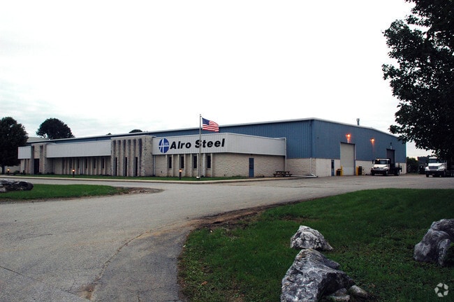
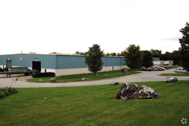
Property Record
130 Keeney Ln, Hellam, PA 17406

Property Detail
130 Keeney Ln
31-000-LL-0058.H0-00000
PP EE-38
Warehouse
York
CM
Pennsylvania
B and X Area of moderate flood hazard, usually the area between the limits of the 100-year and 500-year floods.
29.35 AC
2026
York County
2026
Philadelphia
023400
York-Hanover, PA
66,240 SF
NEARBY LISTINGS FOR SALE OR LEASE
-
-
View all Hellam listings for sale on LoopNet.com
DEMOGRAPHICS near 130 Keeney Ln
1 mile
3 mile
5 mile
2025 Total Population
422
13,668
46,289
2030 Population
434
14,077
47,493
Pop Growth 2025-2030
+ 2.84%
+ 2.99%
+ 2.60%
Average Age
46
42
42
2025 Total Households
173
5,733
18,426
HH Growth 2025-2030
+ 2.89%
+ 3.02%
+ 2.63%
Median Household Inc
$106,081
$79,110
$76,727
Avg Household Size
2.40
2.40
2.40
2025 Avg HH Vehicles
3.00
2.00
2.00
Median Home Value
$278,333
$221,811
$242,339
Median Year Built
1976
1972
1971
Nearby Places
Map Layers
Map Styles
 Street
 Aerial
Layers
 Traffic
 Biking
Places
Listings with unknown addresses are not visible on the map
- Restaurants
- Banks
- Shops
- Fitness
- Groceries
PUBLIC TRANSPORTATION
AIRPORT
Harrisburg International
Drive
Walk
Distance
Harrisburg International
46 min
25.8 mi
Freight Ports
Port of Baltimore
Drive
Walk
Distance
Port of Baltimore
93 min
63.3 mi
Nearby Properties
Address
Land Use
TOTAL SIZE
Lot Size
Zoning
Address
Land Use
TOTAL SIZE
Lot Size
Zoning
293,808 SF
52.26 AC
I
Address
Land Use
TOTAL SIZE
Lot Size
Zoning
166,726 SF
17.44 AC
GC
Address
Land Use
TOTAL SIZE
Lot Size
Zoning
181,119 SF
8.84 AC
Address
Land Use
TOTAL SIZE
Lot Size
Zoning
222,128 SF
28.10 AC
I
Address
Land Use
TOTAL SIZE
Lot Size
Zoning
30,240 SF
12.73 AC
RO
Address
Land Use
TOTAL SIZE
Lot Size
Zoning
14.39 AC
I
Address
Land Use
TOTAL SIZE
Lot Size
Zoning
52,704 SF
14.64 AC
R
Address
Land Use
TOTAL SIZE
Lot Size
Zoning
125,359 SF
7.74 AC
I
Address
Land Use
TOTAL SIZE
Lot Size
Zoning
60,480 SF
5.28 AC
RO
Address
Land Use
TOTAL SIZE
Lot Size
Zoning
60,480 SF
5.09 AC
RO
Address
Land Use
TOTAL SIZE
Lot Size
Zoning
27,072 SF
14.86 AC
RS
Address
Land Use
TOTAL SIZE
Lot Size
Zoning
26,208 SF
5.15 AC
RO
Address
Land Use
TOTAL SIZE
Lot Size
Zoning
129,444 SF
17.70 AC
I
Address
Land Use
TOTAL SIZE
Lot Size
Zoning
73,700 SF
6.75 AC
I
Address
Land Use
TOTAL SIZE
Lot Size
Zoning
76,103 SF
17.51 AC
ID
Address
Land Use
TOTAL SIZE
Lot Size
Zoning
32,029 SF
17.20 AC
GC
Address
Land Use
TOTAL SIZE
Lot Size
Zoning
3,327 SF
7.50 AC
MU1
Address
Land Use
TOTAL SIZE
Lot Size
Zoning
1,144 SF
152.51 AC
R
Address
Land Use
TOTAL SIZE
Lot Size
Zoning
24,000 SF
5 AC
ID
Address
Land Use
TOTAL SIZE
Lot Size
Zoning
107,402 SF
2.49 AC
Address
Land Use
TOTAL SIZE
Lot Size
Zoning
39,184 SF
2.80 AC
MF
Address
Land Use
TOTAL SIZE
Lot Size
Zoning
41,180 SF
13.16 AC
CI
Address
Land Use
TOTAL SIZE
Lot Size
Zoning
2,737 SF
78.89 AC
CI
Address
Land Use
TOTAL SIZE
Lot Size
Zoning
28,860 SF
1.20 AC
TR
Address
Land Use
TOTAL SIZE
Lot Size
Zoning
896 SF
139.50 AC
RS
Address
Land Use
TOTAL SIZE
Lot Size
Zoning
17,248 SF
3.50 AC
RA
Address
Land Use
TOTAL SIZE
Lot Size
Zoning
800 SF
18.85 AC
RS
Address
Land Use
TOTAL SIZE
Lot Size
Zoning
18,274 SF
3.78 AC
CM
Address
Land Use
TOTAL SIZE
Lot Size
Zoning
12,680 SF
23.78 AC
The World's #1 Commercial Real Estate Marketplace
Connect with us
© 2026 CoStar Group
The information above has been obtained from sources believed reliable. While we do not doubt its accuracy we have not verified it and make no guarantee, warranty or representation about it. It is your responsibility to independently confirm its accuracy and completeness. Any projections, opinions, assumptions, or estimates used are for example only and do not represent the current or future performance of the property. The value of this transaction to you depends on tax and other factors which should be evaluated by your tax, financial, and legal advisors. You and your advisors should conduct a careful, independent investigation of the property to determine to your satisfaction the suitability of the property for your needs.