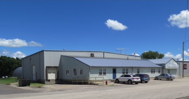
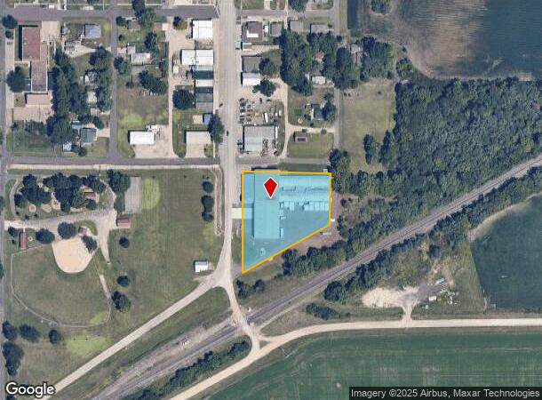
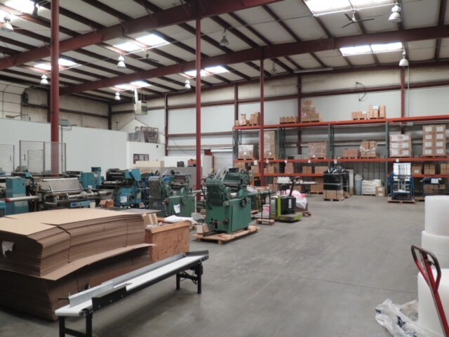
Property Record
130 Main St, Maple Hill, KS 66507
NEARBY LISTINGS FOR SALE OR LEASE
-
-
View all Maple Hill listings for sale on LoopNet.com
Property Detail
130 Main St
Topeka, KS
Maple Hill
096-24-0-10-16-001.00-0
MAPLE HILL, LTS 22,24,26,28,30,32,34,36,38 & 40 MAIN ST & LTS 29,31,33,35 ,37,39 PRAIRE AVE & VACATED ELM ST BETWEEN MAIN & PRAIRE & SECTION 24 TOWNSHIP 11 RANGE 12E
Heavyindustrial
Wabaunsee
X
Kansas
20197C0235C
22,24
2024
1.81 AC
2025
Topeka
483100
Kansas City
37,315 SF
DEMOGRAPHICS near 130 Main St
1 Mile
3 Mile
5 Mile
2024 Total Population
667
750
1,247
2029 Population
691
777
1,283
Pop Growth 2024-2029
+ 3.60%
+ 3.60%
+ 2.89%
Average Age
36
36
38
2024 Total Households
216
244
427
HH Growth 2024-2029
+ 3.70%
+ 3.28%
+ 2.81%
Median Household Inc
$84,642
$84,062
$83,214
Avg Household Size
2.90
2.90
2.80
2024 Avg HH Vehicles
2.00
2.00
2.00
Median Home Value
$154,705
$155,789
$179,477
Median Year Built
1975
1975
1975
Nearby Places
Map Layers
Map Styles
 Street
 Aerial
- Restaurants
- Banks
- Shops
- Fitness
- Groceries
SALE & LEASE HISTORY
LISTING DATE
SALE/LEASE

Jul 03, 2018
For Sale
Nearby Properties
Address
Land Use
TOTAL SIZE
Lot Size
Zoning
Address
Land Use
TOTAL SIZE
Lot Size
Zoning
17,603 SF
1.45 AC
Address
Land Use
TOTAL SIZE
Lot Size
Zoning
1,148 SF
Address
Land Use
TOTAL SIZE
Lot Size
Zoning
5,062 SF
0.32 AC
Address
Land Use
TOTAL SIZE
Lot Size
Zoning
720 SF
0.19 AC
Address
Land Use
TOTAL SIZE
Lot Size
Zoning
3,280 SF
0.29 AC
Address
Land Use
TOTAL SIZE
Lot Size
Zoning
3,200 SF
0.32 AC
Address
Land Use
TOTAL SIZE
Lot Size
Zoning
1,621 SF
11.87 AC
Address
Land Use
TOTAL SIZE
Lot Size
Zoning
11,100 SF
12.29 AC
Address
Land Use
TOTAL SIZE
Lot Size
Zoning
1.61 AC
Address
Land Use
TOTAL SIZE
Lot Size
Zoning
1.70 AC
Address
Land Use
TOTAL SIZE
Lot Size
Zoning
4,164 SF
0.25 AC
Address
Land Use
TOTAL SIZE
Lot Size
Zoning
466.02 AC
Address
Land Use
TOTAL SIZE
Lot Size
Zoning
1,148 SF
12.20 AC
Address
Land Use
TOTAL SIZE
Lot Size
Zoning
5,184 SF
0.19 AC
Address
Land Use
TOTAL SIZE
Lot Size
Zoning
13.93 AC
Address
Land Use
TOTAL SIZE
Lot Size
Zoning
322.94 AC
Address
Land Use
TOTAL SIZE
Lot Size
Zoning
0.64 AC
Address
Land Use
TOTAL SIZE
Lot Size
Zoning
6,400 SF
0.64 AC
Address
Land Use
TOTAL SIZE
Lot Size
Zoning
Address
Land Use
TOTAL SIZE
Lot Size
Zoning
1,430 SF
0.17 AC
Address
Land Use
TOTAL SIZE
Lot Size
Zoning
143.92 AC
Address
Land Use
TOTAL SIZE
Lot Size
Zoning
152.70 AC
Address
Land Use
TOTAL SIZE
Lot Size
Zoning
Address
Land Use
TOTAL SIZE
Lot Size
Zoning
144.10 AC
Address
Land Use
TOTAL SIZE
Lot Size
Zoning
1.20 AC
Address
Land Use
TOTAL SIZE
Lot Size
Zoning
1,189 SF
0.77 AC
Address
Land Use
TOTAL SIZE
Lot Size
Zoning
1,588 SF
0.16 AC
Address
Land Use
TOTAL SIZE
Lot Size
Zoning
129.83 AC
Address
Land Use
TOTAL SIZE
Lot Size
Zoning
2,560 SF
0.24 AC
The World's #1 Commercial Real Estate Marketplace
Connect with us
© 2025 CoStar Group
The information above has been obtained from sources believed reliable. While we do not doubt its accuracy we have not verified it and make no guarantee, warranty or representation about it. It is your responsibility to independently confirm its accuracy and completeness. Any projections, opinions, assumptions, or estimates used are for example only and do not represent the current or future performance of the property. The value of this transaction to you depends on tax and other factors which should be evaluated by your tax, financial, and legal advisors. You and your advisors should conduct a careful, independent investigation of the property to determine to your satisfaction the suitability of the property for your needs.