Property Record
130 Maple Rd, Storrs Mansfield, CT 06268
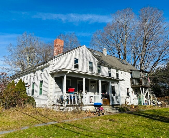

Property Detail
130 Maple Rd
MANS-000022-000058-000019-000001
Capitol
Notresolvable
Connecticut
RAR90
19-1
2025
1.53 AC
2025
Mansfield/Tolland/Willington
881500
Hartford
2,646 SF
Hartford-West Hartford-East Hartford, CT
NEARBY LISTINGS FOR SALE OR LEASE
-
-
View all Storrs Mansfield listings for sale on LoopNet.com
DEMOGRAPHICS near 130 Maple Rd
1 mile
3 mile
5 mile
2025 Total Population
2,407
21,242
47,139
2030 Population
2,518
21,732
48,241
Pop Growth 2025-2030
+ 4.61%
+ 2.31%
+ 2.34%
Average Age
38
30
35
2025 Total Households
864
4,409
14,326
HH Growth 2025-2030
+ 5.56%
+ 3.67%
+ 2.94%
Median Household Inc
$39,444
$68,461
$66,215
Avg Household Size
2.10
2.20
2.30
2025 Avg HH Vehicles
1.00
2.00
2.00
Median Home Value
$417,895
$355,720
$299,111
Median Year Built
1985
1977
1972
Nearby Places
Map Layers
Map Styles
 Street
 Aerial
Layers
 Traffic
 Biking
Places
Listings with unknown addresses are not visible on the map
- Restaurants
- Banks
- Shops
- Fitness
- Groceries
PUBLIC TRANSPORTATION
AIRPORT
Bradley International
Drive
Walk
Distance
Bradley International
64 min
36.9 mi
SALE & LEASE HISTORY
LISTING DATE
SALE/LEASE

Nov 16, 2023
For Sale
Dec 21, 2023
For Sale
Nearby Properties
Address
Land Use
TOTAL SIZE
Lot Size
Zoning
Address
Land Use
TOTAL SIZE
Lot Size
Zoning
253,885 SF
I
Address
Land Use
TOTAL SIZE
Lot Size
Zoning
121,528 SF
Address
Land Use
TOTAL SIZE
Lot Size
Zoning
257,360 SF
1 AC
I
Address
Land Use
TOTAL SIZE
Lot Size
Zoning
171,605 SF
5.30 AC
PB4
Address
Land Use
TOTAL SIZE
Lot Size
Zoning
120,135 SF
Address
Land Use
TOTAL SIZE
Lot Size
Zoning
153,234 SF
1 AC
I
Address
Land Use
TOTAL SIZE
Lot Size
Zoning
213,280 SF
1 AC
I
Address
Land Use
TOTAL SIZE
Lot Size
Zoning
203,904 SF
1 AC
I
Address
Land Use
TOTAL SIZE
Lot Size
Zoning
111,455 SF
1 AC
I
Address
Land Use
TOTAL SIZE
Lot Size
Zoning
255,750 SF
1 AC
I
Address
Land Use
TOTAL SIZE
Lot Size
Zoning
47,712 SF
1 AC
I
Address
Land Use
TOTAL SIZE
Lot Size
Zoning
176,832 SF
I
Address
Land Use
TOTAL SIZE
Lot Size
Zoning
Address
Land Use
TOTAL SIZE
Lot Size
Zoning
227,479 SF
2 AC
I
Address
Land Use
TOTAL SIZE
Lot Size
Zoning
35,212 SF
3.20 AC
I
Address
Land Use
TOTAL SIZE
Lot Size
Zoning
Address
Land Use
TOTAL SIZE
Lot Size
Zoning
155,276 SF
1.37 AC
SCDD
Address
Land Use
TOTAL SIZE
Lot Size
Zoning
79,493 SF
16.10 AC
RAR90
Address
Land Use
TOTAL SIZE
Lot Size
Zoning
Address
Land Use
TOTAL SIZE
Lot Size
Zoning
83,869 SF
I
Address
Land Use
TOTAL SIZE
Lot Size
Zoning
Address
Land Use
TOTAL SIZE
Lot Size
Zoning
Address
Land Use
TOTAL SIZE
Lot Size
Zoning
66,136 SF
1 AC
I
Address
Land Use
TOTAL SIZE
Lot Size
Zoning
115,104 SF
1 AC
I
Address
Land Use
TOTAL SIZE
Lot Size
Zoning
99,901 SF
1 AC
I
Address
Land Use
TOTAL SIZE
Lot Size
Zoning
61,837 SF
I
Address
Land Use
TOTAL SIZE
Lot Size
Zoning
21.54 AC
I
Address
Land Use
TOTAL SIZE
Lot Size
Zoning
77,333 SF
1 AC
I
Address
Land Use
TOTAL SIZE
Lot Size
Zoning
88,000 SF
1 AC
Address
Land Use
TOTAL SIZE
Lot Size
Zoning
102,324 SF
1 AC
I
The World's #1 Commercial Real Estate Marketplace
Connect with us
© 2026 CoStar Group
The information above has been obtained from sources believed reliable. While we do not doubt its accuracy we have not verified it and make no guarantee, warranty or representation about it. It is your responsibility to independently confirm its accuracy and completeness. Any projections, opinions, assumptions, or estimates used are for example only and do not represent the current or future performance of the property. The value of this transaction to you depends on tax and other factors which should be evaluated by your tax, financial, and legal advisors. You and your advisors should conduct a careful, independent investigation of the property to determine to your satisfaction the suitability of the property for your needs.