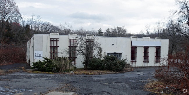
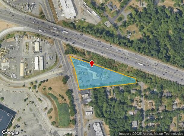
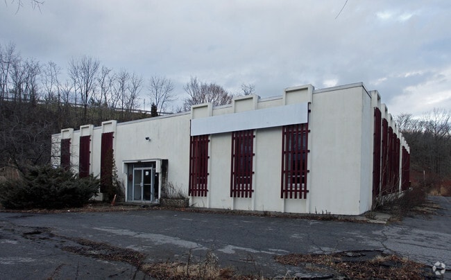
Property Record
130 N Route 303, West Nyack, NY 10994
NEARBY LISTINGS FOR SALE OR LEASE
Property Detail
130 N Route 303
392089-059-018-0001-031-000-0000
106-A-2.2
Regionalshoppingcenterormallwithanchorstore
Rockland
X
New York
36087C0177G
31.0
2023
2.36 AC
2024
Rockland County
011102
Northern New Jersey
13,940 SF
New York-Jersey City-White Plains, NY-NJ
DEMOGRAPHICS near 130 N Route 303
1 Mile
3 Mile
5 Mile
2024 Total Population
4,603
44,312
153,869
2029 Population
4,535
43,955
152,942
Pop Growth 2024-2029
(1.48%)
(0.81%)
(0.60%)
Average Age
42
43
41
2024 Total Households
1,959
16,344
52,740
HH Growth 2024-2029
(1.43%)
(0.89%)
(0.66%)
Median Household Inc
$89,766
$120,066
$112,796
Avg Household Size
2.20
2.60
2.80
2024 Avg HH Vehicles
2.00
2.00
2.00
Median Home Value
$350,617
$585,781
$557,221
Median Year Built
1969
1964
1966
Nearby Places
- Restaurants
- Banks
- Shops
- Fitness
- Groceries
PUBLIC TRANSPORTATION
COMMUTER RAIL
Nanuet (Pascack Valley Line - NJ Transit Commuter Rail (NJ Transit))
DRIVE
WALK
Distance
Nanuet (Pascack Valley Line - NJ Transit Commuter Rail (NJ Transit))
8 min
4.2 mi
Spring Valley (Pascack Valley Line - NJ Transit Commuter Rail (NJ Transit))
DRIVE
WALK
Distance
Spring Valley (Pascack Valley Line - NJ Transit Commuter Rail (NJ Transit))
9 min
5.6 mi
AIRPORT
Westchester County
DRIVE
WALK
Distance
Westchester County
28 min
19.8 mi
LaGuardia
DRIVE
WALK
Distance
LaGuardia
49 min
29.8 mi
New York Stewart International
DRIVE
WALK
Distance
New York Stewart International
55 min
37.8 mi
Freight Ports
NY - Red Hook Container Terminal
DRIVE
WALK
Distance
NY - Red Hook Container Terminal
61 min
34.0 mi
Nearby Properties
Address
Land Use
TOTAL SIZE
Lot Size
Zoning
Address
Land Use
TOTAL SIZE
Lot Size
Zoning
415,374 SF
8.43 AC
H
Address
Land Use
TOTAL SIZE
Lot Size
Zoning
4,540,462 SF
30.89 AC
Address
Land Use
TOTAL SIZE
Lot Size
Zoning
298,975 SF
63.32 AC
03 - MULTI
Address
Land Use
TOTAL SIZE
Lot Size
Zoning
316,644 SF
65.70 AC
Address
Land Use
TOTAL SIZE
Lot Size
Zoning
25.52 AC
Address
Land Use
TOTAL SIZE
Lot Size
Zoning
50,280 SF
24.37 AC
Address
Land Use
TOTAL SIZE
Lot Size
Zoning
108,264 SF
14.90 AC
R-18
Address
Land Use
TOTAL SIZE
Lot Size
Zoning
31.50 AC
R-15
Address
Land Use
TOTAL SIZE
Lot Size
Zoning
302.70 AC
R-40
Address
Land Use
TOTAL SIZE
Lot Size
Zoning
345,670 SF
49.40 AC
Address
Land Use
TOTAL SIZE
Lot Size
Zoning
247,496 SF
24.20 AC
Address
Land Use
TOTAL SIZE
Lot Size
Zoning
1.10 AC
R-3
Address
Land Use
TOTAL SIZE
Lot Size
Zoning
984 SF
3.10 AC
LI
Address
Land Use
TOTAL SIZE
Lot Size
Zoning
1,887 SF
245.60 AC
02 - SINGL
Address
Land Use
TOTAL SIZE
Lot Size
Zoning
Address
Land Use
TOTAL SIZE
Lot Size
Zoning
441.47 AC
R-40
Address
Land Use
TOTAL SIZE
Lot Size
Zoning
68,910 SF
27 AC
Address
Land Use
TOTAL SIZE
Lot Size
Zoning
500,448 SF
29.92 AC
Address
Land Use
TOTAL SIZE
Lot Size
Zoning
142,608 SF
5.60 AC
HRA
Address
Land Use
TOTAL SIZE
Lot Size
Zoning
Address
Land Use
TOTAL SIZE
Lot Size
Zoning
129,957 SF
21.90 AC
Address
Land Use
TOTAL SIZE
Lot Size
Zoning
184.50 AC
R-40
Address
Land Use
TOTAL SIZE
Lot Size
Zoning
95,890 SF
60 AC
Address
Land Use
TOTAL SIZE
Lot Size
Zoning
68,910 SF
6.90 AC
02 - SINGL
Address
Land Use
TOTAL SIZE
Lot Size
Zoning
215,345 SF
18.60 AC
LO
Address
Land Use
TOTAL SIZE
Lot Size
Zoning
34.45 AC
Address
Land Use
TOTAL SIZE
Lot Size
Zoning
8.80 AC
R-1
Address
Land Use
TOTAL SIZE
Lot Size
Zoning
176,522 SF
11.83 AC
LO
Address
Land Use
TOTAL SIZE
Lot Size
Zoning
108,115 SF
2.21 AC
M
Address
Land Use
TOTAL SIZE
Lot Size
Zoning
142,143 SF
14 AC
R-18
The World's #1 Commercial Real Estate Marketplace
Connect with us
© 2025 CoStar Group
The information above has been obtained from sources believed reliable. While we do not doubt its accuracy we have not verified it and make no guarantee, warranty or representation about it. It is your responsibility to independently confirm its accuracy and completeness. Any projections, opinions, assumptions, or estimates used are for example only and do not represent the current or future performance of the property. The value of this transaction to you depends on tax and other factors which should be evaluated by your tax, financial, and legal advisors. You and your advisors should conduct a careful, independent investigation of the property to determine to your satisfaction the suitability of the property for your needs.