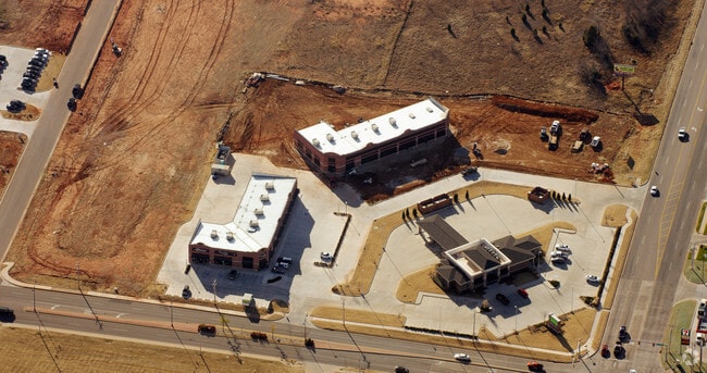
Property Record
100 Ne 150Th St, Edmond, OK 73013

NEARBY LISTINGS FOR SALE OR LEASE
Property Detail
100 Ne 150Th St
144011095
Unpltd Pt Sec 10 13N 3W
Financialbuilding
UNPLTD PT SEC 10 13N 3W 000 000 PT NW4 SEC 10 13N 3W BEG NW/C OF NW4 TH E360.07FT S82.95FT W42.49FT S156.59FT SWLY146.02FT W129.43FT S9.02FT W85.07FT N352.52FT TO BEG
X
Oklahoma
40109C0160H
Oklahoma
2023
4.13 AC
2024
North
108318
Oklahoma City
5,408 SF
Oklahoma City, OK
DEMOGRAPHICS near 100 Ne 150Th St
1 Mile
3 Mile
5 Mile
2024 Total Population
6,967
80,102
186,122
2029 Population
7,047
81,793
190,481
Pop Growth 2024-2029
+ 1.15%
+ 2.11%
+ 2.34%
Average Age
39
37
37
2024 Total Households
2,632
33,835
76,516
HH Growth 2024-2029
+ 1.18%
+ 2.39%
+ 2.49%
Median Household Inc
$93,647
$63,500
$70,071
Avg Household Size
2.60
2.30
2.30
2024 Avg HH Vehicles
2.00
2.00
2.00
Median Home Value
$233,908
$207,538
$238,306
Median Year Built
1994
1992
1989
Nearby Places
Map Layers
Map Styles
 Street
 Aerial
- Restaurants
- Banks
- Shops
- Fitness
- Groceries
PUBLIC TRANSPORTATION
AIRPORT
Will Rogers World
DRIVE
WALK
Distance
Will Rogers World
35 min
21.3 mi
Freight Ports
Tulsa Port Of Catoosa
DRIVE
WALK
Distance
Tulsa Port Of Catoosa
129 min
119.0 mi
Nearby Properties
Address
Land Use
TOTAL SIZE
Lot Size
Zoning
Address
Land Use
TOTAL SIZE
Lot Size
Zoning
460,954 SF
24.83 AC
PUD
Address
Land Use
TOTAL SIZE
Lot Size
Zoning
594,334 SF
71.64 AC
C-3
Address
Land Use
TOTAL SIZE
Lot Size
Zoning
366,844 SF
18.47 AC
PUD
Address
Land Use
TOTAL SIZE
Lot Size
Zoning
469,063 SF
71.44 AC
I-2
Address
Land Use
TOTAL SIZE
Lot Size
Zoning
376,079 SF
29.77 AC
PUD
Address
Land Use
TOTAL SIZE
Lot Size
Zoning
8,354 SF
16.65 AC
PUD
Address
Land Use
TOTAL SIZE
Lot Size
Zoning
391,776 SF
10.12 AC
PUD
Address
Land Use
TOTAL SIZE
Lot Size
Zoning
268,796 SF
45.68 AC
I-2
Address
Land Use
TOTAL SIZE
Lot Size
Zoning
304,423 SF
31.20 AC
PUD
Address
Land Use
TOTAL SIZE
Lot Size
Zoning
399,688 SF
80.57 AC
PUD
Address
Land Use
TOTAL SIZE
Lot Size
Zoning
184,238 SF
7.35 AC
C-3
Address
Land Use
TOTAL SIZE
Lot Size
Zoning
358,436 SF
18.03 AC
PUD
Address
Land Use
TOTAL SIZE
Lot Size
Zoning
297,836 SF
15 AC
PUD
Address
Land Use
TOTAL SIZE
Lot Size
Zoning
470,139 SF
80.39 AC
I-2
Address
Land Use
TOTAL SIZE
Lot Size
Zoning
291,228 SF
14.15 AC
PUD
Address
Land Use
TOTAL SIZE
Lot Size
Zoning
255,921 SF
9.93 AC
PUD
Address
Land Use
TOTAL SIZE
Lot Size
Zoning
285,136 SF
13.04 AC
PUD
Address
Land Use
TOTAL SIZE
Lot Size
Zoning
158,078 SF
15.58 AC
PUD
Address
Land Use
TOTAL SIZE
Lot Size
Zoning
12,633 SF
2 AC
C-3
Address
Land Use
TOTAL SIZE
Lot Size
Zoning
191,504 SF
20.03 AC
PUD
Address
Land Use
TOTAL SIZE
Lot Size
Zoning
316,212 SF
16.36 AC
PUD
Address
Land Use
TOTAL SIZE
Lot Size
Zoning
279,215 SF
11.58 AC
PUD
Address
Land Use
TOTAL SIZE
Lot Size
Zoning
225,492 SF
11.86 AC
R-4
Address
Land Use
TOTAL SIZE
Lot Size
Zoning
13,101 SF
1.22 AC
PUD
Address
Land Use
TOTAL SIZE
Lot Size
Zoning
200,836 SF
10.79 AC
R-4
Address
Land Use
TOTAL SIZE
Lot Size
Zoning
43,489 SF
14.86 AC
PUD
Address
Land Use
TOTAL SIZE
Lot Size
Zoning
140,153 SF
13.07 AC
PUD
Address
Land Use
TOTAL SIZE
Lot Size
Zoning
7.42 AC
PUD
Address
Land Use
TOTAL SIZE
Lot Size
Zoning
242,907 SF
I-2
Address
Land Use
TOTAL SIZE
Lot Size
Zoning
333,902 SF
19.32 AC
PUD
The World's #1 Commercial Real Estate Marketplace
Connect with us
© 2025 CoStar Group
The information above has been obtained from sources believed reliable. While we do not doubt its accuracy we have not verified it and make no guarantee, warranty or representation about it. It is your responsibility to independently confirm its accuracy and completeness. Any projections, opinions, assumptions, or estimates used are for example only and do not represent the current or future performance of the property. The value of this transaction to you depends on tax and other factors which should be evaluated by your tax, financial, and legal advisors. You and your advisors should conduct a careful, independent investigation of the property to determine to your satisfaction the suitability of the property for your needs.