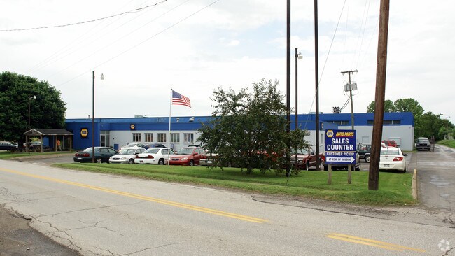
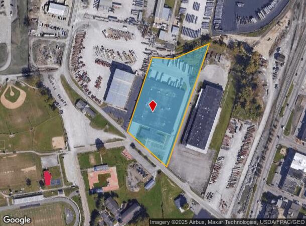
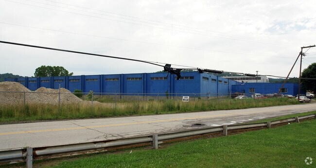
Property Record
130 Plant Rd, Nitro, WV 25143
NEARBY LISTINGS FOR SALE OR LEASE
Property Detail
130 Plant Rd
25-21A-00020000
4-10/100A KANAWHA CO
Warehouse
Kanawha
X
West Virginia
54079C0261D
4.09 AC
2025
Outlying Kanawha County
2025
Charleston WV
020500
Charleston, WV
DEMOGRAPHICS near 130 Plant Rd
1 Mile
3 Mile
5 Mile
2024 Total Population
3,135
18,771
51,097
2029 Population
3,073
18,329
49,852
Pop Growth 2024-2029
(1.98%)
(2.35%)
(2.44%)
Average Age
42
42
42
2024 Total Households
1,439
8,192
21,763
HH Growth 2024-2029
(2.02%)
(2.47%)
(2.50%)
Median Household Inc
$46,956
$49,231
$59,015
Avg Household Size
2.20
2.20
2.30
2024 Avg HH Vehicles
1.00
2.00
2.00
Median Home Value
$127,757
$130,009
$150,193
Median Year Built
1954
1965
1971
Nearby Places
Map Layers
Map Styles
 Street
 Aerial
- Restaurants
- Banks
- Shops
- Fitness
- Groceries
PUBLIC TRANSPORTATION
AIRPORT
West Virginia International Yeager
DRIVE
WALK
Distance
West Virginia International Yeager
27 min
21.3 mi
Freight Ports
Virginia Port Authority - Richmond
DRIVE
WALK
Distance
Virginia Port Authority - Richmond
1 min
250.0 mi
Nearby Properties
Address
Land Use
TOTAL SIZE
Lot Size
Zoning
Address
Land Use
TOTAL SIZE
Lot Size
Zoning
106.70 AC
Address
Land Use
TOTAL SIZE
Lot Size
Zoning
26.28 AC
Address
Land Use
TOTAL SIZE
Lot Size
Zoning
12.83 AC
Address
Land Use
TOTAL SIZE
Lot Size
Zoning
6.49 AC
Address
Land Use
TOTAL SIZE
Lot Size
Zoning
15.57 AC
Address
Land Use
TOTAL SIZE
Lot Size
Zoning
10.43 AC
Address
Land Use
TOTAL SIZE
Lot Size
Zoning
14.53 AC
Address
Land Use
TOTAL SIZE
Lot Size
Zoning
15.43 AC
Address
Land Use
TOTAL SIZE
Lot Size
Zoning
3.51 AC
Address
Land Use
TOTAL SIZE
Lot Size
Zoning
3.18 AC
Address
Land Use
TOTAL SIZE
Lot Size
Zoning
82.09 AC
Address
Land Use
TOTAL SIZE
Lot Size
Zoning
11.77 AC
Address
Land Use
TOTAL SIZE
Lot Size
Zoning
18.12 AC
Address
Land Use
TOTAL SIZE
Lot Size
Zoning
2.13 AC
Address
Land Use
TOTAL SIZE
Lot Size
Zoning
23.49 AC
Address
Land Use
TOTAL SIZE
Lot Size
Zoning
16.95 AC
Address
Land Use
TOTAL SIZE
Lot Size
Zoning
26.95 AC
Address
Land Use
TOTAL SIZE
Lot Size
Zoning
9.02 AC
Address
Land Use
TOTAL SIZE
Lot Size
Zoning
6.62 AC
Address
Land Use
TOTAL SIZE
Lot Size
Zoning
Address
Land Use
TOTAL SIZE
Lot Size
Zoning
7.55 AC
Address
Land Use
TOTAL SIZE
Lot Size
Zoning
69.30 AC
Address
Land Use
TOTAL SIZE
Lot Size
Zoning
Address
Land Use
TOTAL SIZE
Lot Size
Zoning
3.98 AC
Address
Land Use
TOTAL SIZE
Lot Size
Zoning
5.06 AC
Address
Land Use
TOTAL SIZE
Lot Size
Zoning
4.10 AC
Address
Land Use
TOTAL SIZE
Lot Size
Zoning
1.96 AC
Address
Land Use
TOTAL SIZE
Lot Size
Zoning
Address
Land Use
TOTAL SIZE
Lot Size
Zoning
83.12 AC
Address
Land Use
TOTAL SIZE
Lot Size
Zoning
0.48 AC
The World's #1 Commercial Real Estate Marketplace
Connect with us
© 2026 CoStar Group
The information above has been obtained from sources believed reliable. While we do not doubt its accuracy we have not verified it and make no guarantee, warranty or representation about it. It is your responsibility to independently confirm its accuracy and completeness. Any projections, opinions, assumptions, or estimates used are for example only and do not represent the current or future performance of the property. The value of this transaction to you depends on tax and other factors which should be evaluated by your tax, financial, and legal advisors. You and your advisors should conduct a careful, independent investigation of the property to determine to your satisfaction the suitability of the property for your needs.