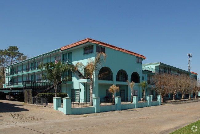
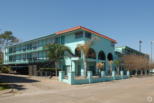
Property Record
130 Surf Ct, Houston, TX 77058

Property Detail
130 Surf Ct
0362370000007
RES DD2 & TR 2B BLK 81 PORTOFINO VILLAGE U/R HOUSTON ORCHARDS
Apartment
HARRIS
AE The base floodplain where base flood elevations are provided. AE Zones are now used on new format FIRMs instead of A1-A30 Zones.
Texas
2024
1.16 AC
2025
Nassau Bay
341204
Houston
37,533 SF
Houston-Pasadena-The Woodlands, TX
NEARBY LISTINGS FOR SALE OR LEASE
DEMOGRAPHICS near 130 Surf Ct
1 mile
3 mile
5 mile
2025 Total Population
6,159
74,671
183,670
2030 Population
6,519
78,586
192,729
Pop Growth 2025-2030
+ 5.85%
+ 5.24%
+ 4.93%
Average Age
41
40
40
2025 Total Households
2,944
32,371
74,736
HH Growth 2025-2030
+ 5.94%
+ 5.43%
+ 5.16%
Median Household Inc
$80,353
$78,660
$94,987
Avg Household Size
2.10
2.30
2.40
2025 Avg HH Vehicles
2.00
2.00
2.00
Median Home Value
$387,689
$335,837
$336,223
Median Year Built
1975
1984
1988
Nearby Places
Map Layers
Map Styles
 Street
 Aerial
Layers
 Traffic
 Biking
Places
Listings with unknown addresses are not visible on the map
- Restaurants
- Banks
- Shops
- Fitness
- Groceries
PUBLIC TRANSPORTATION
AIRPORT
William P Hobby
Drive
Walk
Distance
William P Hobby
29 min
16.4 mi
George Bush Intcntl/Houston
Drive
Walk
Distance
George Bush Intcntl/Houston
57 min
41.8 mi
Freight Ports
Port of Houston
Drive
Walk
Distance
Port of Houston
34 min
22.9 mi
Nearby Properties
Address
Land Use
TOTAL SIZE
Lot Size
Zoning
Address
Land Use
TOTAL SIZE
Lot Size
Zoning
544,605 SF
27.49 AC
Address
Land Use
TOTAL SIZE
Lot Size
Zoning
538,570 SF
16.15 AC
Address
Land Use
TOTAL SIZE
Lot Size
Zoning
645,535 SF
4.40 AC
Address
Land Use
TOTAL SIZE
Lot Size
Zoning
780,870 SF
22.72 AC
Address
Land Use
TOTAL SIZE
Lot Size
Zoning
335,717 SF
21.15 AC
Address
Land Use
TOTAL SIZE
Lot Size
Zoning
502,791 SF
123.05 AC
Address
Land Use
TOTAL SIZE
Lot Size
Zoning
218,198 SF
7.27 AC
Address
Land Use
TOTAL SIZE
Lot Size
Zoning
452,269 SF
29.63 AC
Address
Land Use
TOTAL SIZE
Lot Size
Zoning
530,696 SF
8.57 AC
Address
Land Use
TOTAL SIZE
Lot Size
Zoning
366,202 SF
32.55 AC
Address
Land Use
TOTAL SIZE
Lot Size
Zoning
485,863 SF
4.81 AC
Address
Land Use
TOTAL SIZE
Lot Size
Zoning
372,183 SF
11.16 AC
Address
Land Use
TOTAL SIZE
Lot Size
Zoning
437,909 SF
27.06 AC
Address
Land Use
TOTAL SIZE
Lot Size
Zoning
260,988 SF
11.78 AC
Address
Land Use
TOTAL SIZE
Lot Size
Zoning
372,831 SF
20 AC
Address
Land Use
TOTAL SIZE
Lot Size
Zoning
441,889 SF
17.88 AC
Address
Land Use
TOTAL SIZE
Lot Size
Zoning
282,246 SF
19.56 AC
Address
Land Use
TOTAL SIZE
Lot Size
Zoning
335,315 SF
20 AC
Address
Land Use
TOTAL SIZE
Lot Size
Zoning
334,876 SF
0.86 AC
Address
Land Use
TOTAL SIZE
Lot Size
Zoning
879,410 SF
93.36 AC
Address
Land Use
TOTAL SIZE
Lot Size
Zoning
364,008 SF
21.78 AC
Address
Land Use
TOTAL SIZE
Lot Size
Zoning
126,874 SF
3.92 AC
Address
Land Use
TOTAL SIZE
Lot Size
Zoning
470,930 SF
16.55 AC
Address
Land Use
TOTAL SIZE
Lot Size
Zoning
273,648 SF
11.48 AC
Address
Land Use
TOTAL SIZE
Lot Size
Zoning
114,538 SF
4.65 AC
Address
Land Use
TOTAL SIZE
Lot Size
Zoning
5 SF
12.63 AC
Address
Land Use
TOTAL SIZE
Lot Size
Zoning
325,084 SF
23.74 AC
Address
Land Use
TOTAL SIZE
Lot Size
Zoning
275,775 SF
8.54 AC
Address
Land Use
TOTAL SIZE
Lot Size
Zoning
196,951 SF
10.90 AC
Address
Land Use
TOTAL SIZE
Lot Size
Zoning
101,385 SF
69.03 AC
The World's #1 Commercial Real Estate Marketplace
Connect with us
© 2026 CoStar Group
The information above has been obtained from sources believed reliable. While we do not doubt its accuracy we have not verified it and make no guarantee, warranty or representation about it. It is your responsibility to independently confirm its accuracy and completeness. Any projections, opinions, assumptions, or estimates used are for example only and do not represent the current or future performance of the property. The value of this transaction to you depends on tax and other factors which should be evaluated by your tax, financial, and legal advisors. You and your advisors should conduct a careful, independent investigation of the property to determine to your satisfaction the suitability of the property for your needs.