Property Record
1300 Charles St, Park Rapids, MN 56470
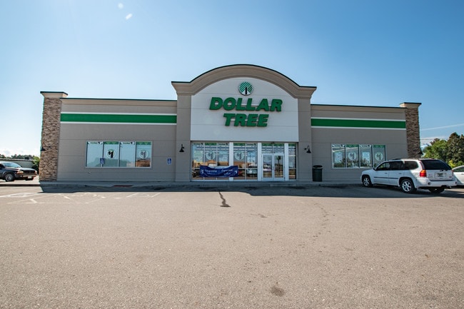


Property Detail
1300 Charles St
Other Market Areas
Real property in the City of Park Rapids, County of Hubbard, State of Minnesota, describedas follows
32.19.00210
Hubbard
Wholesaleoutletdiscountstore
Minnesota
2025
a
2025
1.36 AC
070500
Minnesota North Area
8,056 SF
NEARBY LISTINGS FOR SALE OR LEASE
DEMOGRAPHICS near 1300 Charles St
1 mile
3 mile
5 mile
2025 Total Population
1,481
5,105
6,991
2030 Population
1,467
5,075
7,014
Pop Growth 2025-2030
(0.95%)
(0.59%)
+ 0.33%
Average Age
43
42
43
2025 Total Households
649
2,199
2,965
HH Growth 2025-2030
(1.23%)
(0.91%)
+ 0.07%
Median Household Inc
$62,990
$54,589
$59,973
Avg Household Size
2.10
2.20
2.20
2025 Avg HH Vehicles
2.00
2.00
2.00
Median Home Value
$274,528
$256,363
$269,351
Median Year Built
1982
1977
1979
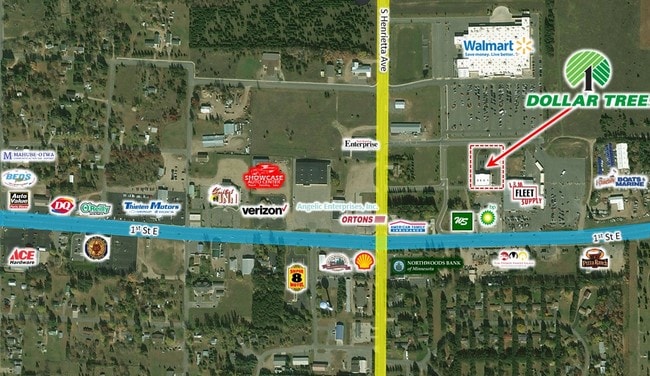
Nearby Places
Map Layers
Map Styles
 Street
 Aerial
Layers
 Traffic
 Biking
Places
Listings with unknown addresses are not visible on the map
- Restaurants
- Banks
- Shops
- Fitness
- Groceries
SALE & LEASE HISTORY
LISTING DATE
SALE/LEASE

Sep 12, 2018
For Sale
Feb 01, 2017
For Sale
Apr 19, 2019
For Sale
Nearby Properties
Address
Land Use
TOTAL SIZE
Lot Size
Zoning
Address
Land Use
TOTAL SIZE
Lot Size
Zoning
187,428 SF
50.08 AC
Address
Land Use
TOTAL SIZE
Lot Size
Zoning
234,702 SF
112.34 AC
Address
Land Use
TOTAL SIZE
Lot Size
Zoning
120,068 SF
4.33 AC
Address
Land Use
TOTAL SIZE
Lot Size
Zoning
14,795 SF
4.15 AC
Address
Land Use
TOTAL SIZE
Lot Size
Zoning
60,517 SF
0.69 AC
Address
Land Use
TOTAL SIZE
Lot Size
Zoning
113,762 SF
20.64 AC
Address
Land Use
TOTAL SIZE
Lot Size
Zoning
33,335 SF
15.68 AC
Address
Land Use
TOTAL SIZE
Lot Size
Zoning
27,216 SF
11.82 AC
Address
Land Use
TOTAL SIZE
Lot Size
Zoning
8,000 SF
510.51 AC
Address
Land Use
TOTAL SIZE
Lot Size
Zoning
94,539 SF
4.67 AC
Address
Land Use
TOTAL SIZE
Lot Size
Zoning
27,216 SF
20 AC
Address
Land Use
TOTAL SIZE
Lot Size
Zoning
39,570 SF
0.79 AC
Address
Land Use
TOTAL SIZE
Lot Size
Zoning
22,680 SF
3.88 AC
Address
Land Use
TOTAL SIZE
Lot Size
Zoning
139,472 SF
36.42 AC
Address
Land Use
TOTAL SIZE
Lot Size
Zoning
18,786 SF
0.48 AC
Address
Land Use
TOTAL SIZE
Lot Size
Zoning
66,173 SF
1.33 AC
Address
Land Use
TOTAL SIZE
Lot Size
Zoning
49,560 SF
3.54 AC
Address
Land Use
TOTAL SIZE
Lot Size
Zoning
54,040 SF
2.50 AC
Address
Land Use
TOTAL SIZE
Lot Size
Zoning
11,148 SF
15 AC
Address
Land Use
TOTAL SIZE
Lot Size
Zoning
36,025 SF
1.28 AC
Address
Land Use
TOTAL SIZE
Lot Size
Zoning
33,320 SF
4.80 AC
Address
Land Use
TOTAL SIZE
Lot Size
Zoning
24,441 SF
1.68 AC
Address
Land Use
TOTAL SIZE
Lot Size
Zoning
21,478 SF
4.61 AC
Address
Land Use
TOTAL SIZE
Lot Size
Zoning
28,330 SF
2.50 AC
Address
Land Use
TOTAL SIZE
Lot Size
Zoning
116,970 SF
10.42 AC
Address
Land Use
TOTAL SIZE
Lot Size
Zoning
27,126 SF
2.58 AC
Address
Land Use
TOTAL SIZE
Lot Size
Zoning
5,058 SF
2.23 AC
Address
Land Use
TOTAL SIZE
Lot Size
Zoning
27,092 SF
2.54 AC
Address
Land Use
TOTAL SIZE
Lot Size
Zoning
14,045 SF
10.91 AC
The World's #1 Commercial Real Estate Marketplace
Connect with us
© 2026 CoStar Group
The information above has been obtained from sources believed reliable. While we do not doubt its accuracy we have not verified it and make no guarantee, warranty or representation about it. It is your responsibility to independently confirm its accuracy and completeness. Any projections, opinions, assumptions, or estimates used are for example only and do not represent the current or future performance of the property. The value of this transaction to you depends on tax and other factors which should be evaluated by your tax, financial, and legal advisors. You and your advisors should conduct a careful, independent investigation of the property to determine to your satisfaction the suitability of the property for your needs.