Property Record
1300 E Main St, Flippin, AR 72634
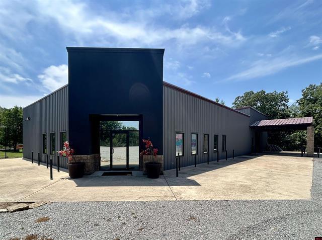


This Property Is For Sale
Property Detail
1300 E Main St
770-05766-000
PT NW NW MPDA BEG PT 512' S NW COR TH S35*E25' N59*E160' TO PT INTERSECTING S SDIE HWY 62 TH NWLY AL SD HWY R/W TO INTERSECTI
Commercialnec
Marion
2025
Arkansas
2025
0.75 AC
960202
Arkansas North Area
2,760 SF
Other Market Areas
NEARBY LISTINGS FOR SALE OR LEASE
-
-
View all Flippin listings for sale on LoopNet.com
DEMOGRAPHICS near 1300 E Main St
1 mile
3 mile
5 mile
2025 Total Population
1,082
3,596
6,795
2030 Population
1,118
3,719
7,020
Pop Growth 2025-2030
+ 3.33%
+ 3.42%
+ 3.31%
Average Age
42
45
45
2025 Total Households
479
1,579
2,951
HH Growth 2025-2030
+ 3.34%
+ 3.29%
+ 3.22%
Median Household Inc
$36,470
$46,794
$49,299
Avg Household Size
2.30
2.20
2.20
2025 Avg HH Vehicles
2.00
2.00
2.00
Median Home Value
$132,639
$159,957
$166,905
Median Year Built
1985
1984
1985
Nearby Places
Map Layers
Map Styles
 Street
 Aerial
Transit
 Traffic
 Biking
Places
Listings with unknown addresses are not visible on the map
- Restaurants
- Banks
- Shops
- Fitness
- Groceries
Nearby Properties
Address
Land Use
TOTAL SIZE
Lot Size
Zoning
Address
Land Use
TOTAL SIZE
Lot Size
Zoning
53,222 SF
7 AC
Address
Land Use
TOTAL SIZE
Lot Size
Zoning
21,566 SF
12.12 AC
Address
Land Use
TOTAL SIZE
Lot Size
Zoning
113,550 SF
32.07 AC
Address
Land Use
TOTAL SIZE
Lot Size
Zoning
103,050 SF
16.05 AC
Address
Land Use
TOTAL SIZE
Lot Size
Zoning
33,992 SF
2.07 AC
Address
Land Use
TOTAL SIZE
Lot Size
Zoning
3,444 SF
1.31 AC
Address
Land Use
TOTAL SIZE
Lot Size
Zoning
24,620 SF
3.18 AC
Address
Land Use
TOTAL SIZE
Lot Size
Zoning
420 SF
5.20 AC
Address
Land Use
TOTAL SIZE
Lot Size
Zoning
39,900 SF
6.04 AC
Address
Land Use
TOTAL SIZE
Lot Size
Zoning
26,399 SF
2.66 AC
Address
Land Use
TOTAL SIZE
Lot Size
Zoning
2,880 SF
3 AC
Address
Land Use
TOTAL SIZE
Lot Size
Zoning
5,656 SF
1.92 AC
Address
Land Use
TOTAL SIZE
Lot Size
Zoning
10,406 SF
2 AC
Address
Land Use
TOTAL SIZE
Lot Size
Zoning
20,000 SF
2.40 AC
Address
Land Use
TOTAL SIZE
Lot Size
Zoning
61,462 SF
10.13 AC
Address
Land Use
TOTAL SIZE
Lot Size
Zoning
4,640 SF
1.30 AC
Address
Land Use
TOTAL SIZE
Lot Size
Zoning
4,922 SF
0.98 AC
Address
Land Use
TOTAL SIZE
Lot Size
Zoning
3,040 SF
0.24 AC
Address
Land Use
TOTAL SIZE
Lot Size
Zoning
5,098 SF
4.13 AC
Address
Land Use
TOTAL SIZE
Lot Size
Zoning
20,200 SF
3.18 AC
Address
Land Use
TOTAL SIZE
Lot Size
Zoning
6,300 SF
1.50 AC
Address
Land Use
TOTAL SIZE
Lot Size
Zoning
8,800 SF
0.91 AC
Address
Land Use
TOTAL SIZE
Lot Size
Zoning
36,550 SF
4.36 AC
Address
Land Use
TOTAL SIZE
Lot Size
Zoning
1,560 SF
2.45 AC
Address
Land Use
TOTAL SIZE
Lot Size
Zoning
4,205 SF
1.50 AC
Address
Land Use
TOTAL SIZE
Lot Size
Zoning
Address
Land Use
TOTAL SIZE
Lot Size
Zoning
9,600 SF
10.14 AC
Address
Land Use
TOTAL SIZE
Lot Size
Zoning
4,285 SF
1.37 AC
Address
Land Use
TOTAL SIZE
Lot Size
Zoning
14,482 SF
2.81 AC
Address
Land Use
TOTAL SIZE
Lot Size
Zoning
10,960 SF
1.03 AC
The World's #1 Commercial Real Estate Marketplace
Connect with us
© 2026 CoStar Group
The information above has been obtained from sources believed reliable. While we do not doubt its accuracy we have not verified it and make no guarantee, warranty or representation about it. It is your responsibility to independently confirm its accuracy and completeness. Any projections, opinions, assumptions, or estimates used are for example only and do not represent the current or future performance of the property. The value of this transaction to you depends on tax and other factors which should be evaluated by your tax, financial, and legal advisors. You and your advisors should conduct a careful, independent investigation of the property to determine to your satisfaction the suitability of the property for your needs.