Property Record
1300 Hilltop Ave, Chicago Heights, IL 60411

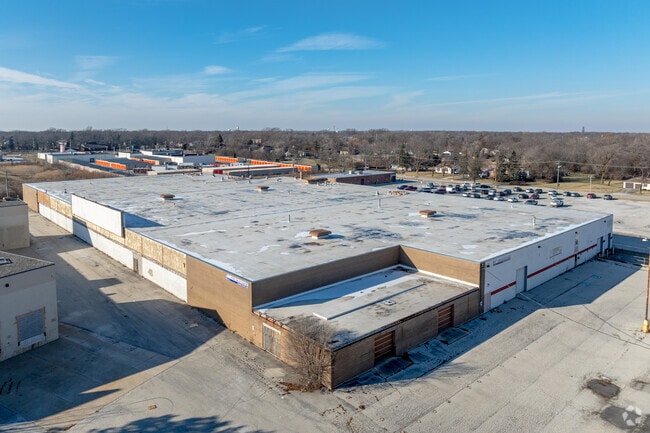
This Property Is For Sale
Current Lease Availabilities
NEARBY LISTINGS FOR SALE OR LEASE
Property Detail
1300 Hilltop Ave
32-19-101-021-0000
Cook
Industrialgeneral
Illinois
X
0.58 AC
17031C0743J
Far South Cook
2023
Chicago
2025
Chicago-Naperville-Elgin, IL-IN
829302
DEMOGRAPHICS near 1300 Hilltop Ave
1 Mile
3 Mile
5 Mile
2024 Total Population
12,019
86,860
177,736
2029 Population
11,843
85,499
174,449
Pop Growth 2024-2029
(1.46%)
(1.57%)
(1.85%)
Average Age
40
40
40
2024 Total Households
4,037
32,102
65,711
HH Growth 2024-2029
(1.81%)
(1.93%)
(2.15%)
Median Household Inc
$63,791
$61,957
$66,275
Avg Household Size
2.80
2.60
2.60
2024 Avg HH Vehicles
2.00
2.00
2.00
Median Home Value
$148,652
$146,180
$157,650
Median Year Built
1966
1962
1968
Nearby Places
Map Layers
Map Styles
 Street
 Aerial
- Restaurants
- Banks
- Shops
- Fitness
- Groceries
PUBLIC TRANSPORTATION
COMMUTER RAIL
211Th Street (Lincoln Highway) Station (Metra Electric Line - Northeast Illinois Regional Commuter Railroad (Metra))
DRIVE
WALK
Distance
211Th Street (Lincoln Highway) Station (Metra Electric Line - Northeast Illinois Regional Commuter Railroad (Metra))
4 min
1.6 mi
Olympia Fields Station (Metra Electric Line - Northeast Illinois Regional Commuter Railroad (Metra))
DRIVE
WALK
Distance
Olympia Fields Station (Metra Electric Line - Northeast Illinois Regional Commuter Railroad (Metra))
6 min
2.9 mi
AIRPORT
Chicago Midway International
DRIVE
WALK
Distance
Chicago Midway International
39 min
24.6 mi
Freight Ports
Port Milwaukee
DRIVE
WALK
Distance
Port Milwaukee
146 min
118.1 mi
Nearby Properties
Address
Land Use
TOTAL SIZE
Lot Size
Zoning
Address
Land Use
TOTAL SIZE
Lot Size
Zoning
Address
Land Use
TOTAL SIZE
Lot Size
Zoning
37.62 AC
Address
Land Use
TOTAL SIZE
Lot Size
Zoning
Address
Land Use
TOTAL SIZE
Lot Size
Zoning
194,292 SF
21.10 AC
Address
Land Use
TOTAL SIZE
Lot Size
Zoning
78,884 SF
5.60 AC
Address
Land Use
TOTAL SIZE
Lot Size
Zoning
300,399 SF
26.50 AC
Address
Land Use
TOTAL SIZE
Lot Size
Zoning
Address
Land Use
TOTAL SIZE
Lot Size
Zoning
1,201 SF
3.65 AC
Address
Land Use
TOTAL SIZE
Lot Size
Zoning
31,952 SF
4.03 AC
Address
Land Use
TOTAL SIZE
Lot Size
Zoning
2.94 AC
Address
Land Use
TOTAL SIZE
Lot Size
Zoning
234,478 SF
13.22 AC
Address
Land Use
TOTAL SIZE
Lot Size
Zoning
2.04 AC
Address
Land Use
TOTAL SIZE
Lot Size
Zoning
Address
Land Use
TOTAL SIZE
Lot Size
Zoning
183,041 SF
18.71 AC
Address
Land Use
TOTAL SIZE
Lot Size
Zoning
3.65 AC
Address
Land Use
TOTAL SIZE
Lot Size
Zoning
90,908 SF
1.78 AC
Address
Land Use
TOTAL SIZE
Lot Size
Zoning
37,522 SF
2.78 AC
Address
Land Use
TOTAL SIZE
Lot Size
Zoning
Address
Land Use
TOTAL SIZE
Lot Size
Zoning
Address
Land Use
TOTAL SIZE
Lot Size
Zoning
37,309 SF
1.50 AC
Address
Land Use
TOTAL SIZE
Lot Size
Zoning
44,000 SF
1.44 AC
Address
Land Use
TOTAL SIZE
Lot Size
Zoning
6.58 AC
Address
Land Use
TOTAL SIZE
Lot Size
Zoning
189,489 SF
20 AC
Address
Land Use
TOTAL SIZE
Lot Size
Zoning
49,800 SF
4.42 AC
Address
Land Use
TOTAL SIZE
Lot Size
Zoning
24,508 SF
1.13 AC
Address
Land Use
TOTAL SIZE
Lot Size
Zoning
Address
Land Use
TOTAL SIZE
Lot Size
Zoning
6,350 SF
1.16 AC
Address
Land Use
TOTAL SIZE
Lot Size
Zoning
Address
Land Use
TOTAL SIZE
Lot Size
Zoning
Address
Land Use
TOTAL SIZE
Lot Size
Zoning
185,893 SF
16.74 AC
The World's #1 Commercial Real Estate Marketplace
Connect with us
© 2026 CoStar Group
The information above has been obtained from sources believed reliable. While we do not doubt its accuracy we have not verified it and make no guarantee, warranty or representation about it. It is your responsibility to independently confirm its accuracy and completeness. Any projections, opinions, assumptions, or estimates used are for example only and do not represent the current or future performance of the property. The value of this transaction to you depends on tax and other factors which should be evaluated by your tax, financial, and legal advisors. You and your advisors should conduct a careful, independent investigation of the property to determine to your satisfaction the suitability of the property for your needs.