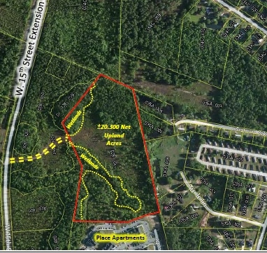
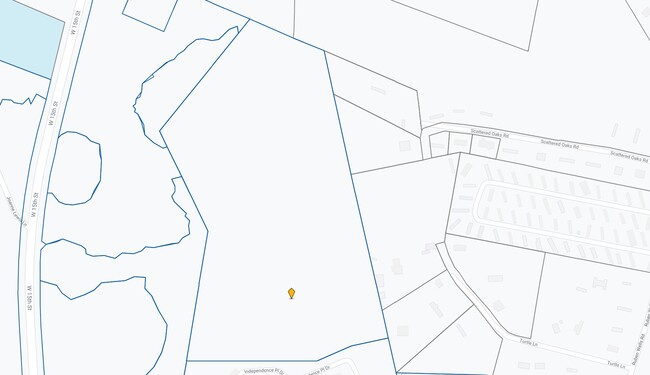
Property Record
1300 Independence Place Dr, Hinesville, GA 31313

NEARBY LISTINGS FOR SALE OR LEASE
Property Detail
1300 Independence Place Dr
035C-001
Gmass Commercial
Commercialnec
TRACT F3-AI (INDEPENDENCE PLACE APTS)
X
Liberty
13179C0210E
Georgia
2024
41.57 AC
2024
Liberty County
010206
Savannah
258,552 SF
Hinesville, GA
DEMOGRAPHICS near 1300 Independence Place Dr
1 Mile
3 Mile
5 Mile
2024 Total Population
3,144
23,399
53,712
2029 Population
3,294
24,487
57,563
Pop Growth 2024-2029
+ 4.77%
+ 4.65%
+ 7.17%
Average Age
29
32
32
2024 Total Households
1,204
8,825
18,561
HH Growth 2024-2029
+ 5.07%
+ 4.83%
+ 7.33%
Median Household Inc
$54,075
$48,755
$49,016
Avg Household Size
2.60
2.60
2.70
2024 Avg HH Vehicles
2.00
2.00
2.00
Median Home Value
$195,803
$143,854
$155,395
Median Year Built
2001
1992
1992
Nearby Places
Map Layers
Map Styles
 Street
 Aerial
- Restaurants
- Banks
- Shops
- Fitness
- Groceries
SALE & LEASE HISTORY
LISTING DATE
SALE/LEASE

Sep 24, 2016
For Sale
Nearby Properties
Address
Land Use
TOTAL SIZE
Lot Size
Zoning
Address
Land Use
TOTAL SIZE
Lot Size
Zoning
24,288 SF
12.05 AC
PUD
Address
Land Use
TOTAL SIZE
Lot Size
Zoning
100,765 SF
33.20 AC
C2
Address
Land Use
TOTAL SIZE
Lot Size
Zoning
90,886 SF
10.78 AC
C2
Address
Land Use
TOTAL SIZE
Lot Size
Zoning
81,366 SF
28.01 AC
R20
Address
Land Use
TOTAL SIZE
Lot Size
Zoning
1,884 SF
9.25 AC
C2
Address
Land Use
TOTAL SIZE
Lot Size
Zoning
81,366 SF
35.17 AC
R8
Address
Land Use
TOTAL SIZE
Lot Size
Zoning
205,730 SF
21.03 AC
C3
Address
Land Use
TOTAL SIZE
Lot Size
Zoning
155,001 SF
10.56 AC
MFR
Address
Land Use
TOTAL SIZE
Lot Size
Zoning
133,379 SF
15.59 AC
C2
Address
Land Use
TOTAL SIZE
Lot Size
Zoning
12,261 SF
10.99 AC
C2
Address
Land Use
TOTAL SIZE
Lot Size
Zoning
39,252 SF
4.93 AC
MFR
Address
Land Use
TOTAL SIZE
Lot Size
Zoning
14,274 SF
6.34 AC
MFR
Address
Land Use
TOTAL SIZE
Lot Size
Zoning
2,969 SF
24.68 AC
MFR
Address
Land Use
TOTAL SIZE
Lot Size
Zoning
8,520 SF
5.87 AC
C3
Address
Land Use
TOTAL SIZE
Lot Size
Zoning
9,320 SF
6.74 AC
C2/C3
Address
Land Use
TOTAL SIZE
Lot Size
Zoning
777 SF
5.97 AC
MFR
Address
Land Use
TOTAL SIZE
Lot Size
Zoning
17,000 SF
1.99 AC
C3
Address
Land Use
TOTAL SIZE
Lot Size
Zoning
46,592 SF
10.49 AC
MFR
Address
Land Use
TOTAL SIZE
Lot Size
Zoning
1,078 SF
8 AC
MFR
Address
Land Use
TOTAL SIZE
Lot Size
Zoning
10,857 SF
1.20 AC
C2
Address
Land Use
TOTAL SIZE
Lot Size
Zoning
25,640 SF
1.43 AC
C2
Address
Land Use
TOTAL SIZE
Lot Size
Zoning
42,240 SF
4.80 AC
MFR
Address
Land Use
TOTAL SIZE
Lot Size
Zoning
12,548 SF
12.47 AC
MFR
Address
Land Use
TOTAL SIZE
Lot Size
Zoning
18,288 SF
0.98 AC
C2
Address
Land Use
TOTAL SIZE
Lot Size
Zoning
3,500 SF
3.36 AC
MFR
Address
Land Use
TOTAL SIZE
Lot Size
Zoning
21,406 SF
1.88 AC
C2
Address
Land Use
TOTAL SIZE
Lot Size
Zoning
14,982 SF
2.07 AC
R20
Address
Land Use
TOTAL SIZE
Lot Size
Zoning
3,990 SF
1.93 AC
OI
The World's #1 Commercial Real Estate Marketplace
Connect with us
© 2026 CoStar Group
The information above has been obtained from sources believed reliable. While we do not doubt its accuracy we have not verified it and make no guarantee, warranty or representation about it. It is your responsibility to independently confirm its accuracy and completeness. Any projections, opinions, assumptions, or estimates used are for example only and do not represent the current or future performance of the property. The value of this transaction to you depends on tax and other factors which should be evaluated by your tax, financial, and legal advisors. You and your advisors should conduct a careful, independent investigation of the property to determine to your satisfaction the suitability of the property for your needs.