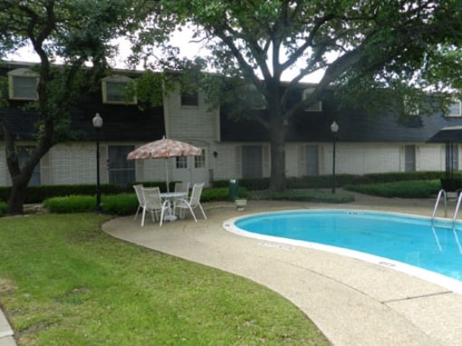
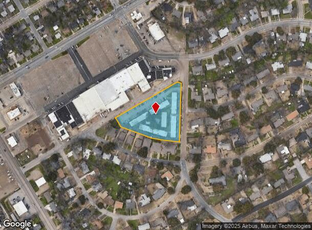
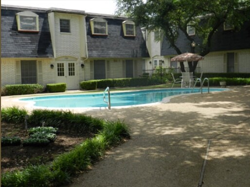
Property Record
1300 N 43Rd St, Waco, TX 76710
NEARBY LISTINGS FOR SALE OR LEASE
Property Detail
1300 N 43Rd St
Waco, TX
Stenzel
48-038601-000301-5
STENZEL LOT 3 BLOCK 1 ACRES 2.165
Apartment
Mclennan
X
Texas
48309C0366D
3
2024
2.17 AC
2025
Waco & Killeen
002498
Other Market Areas
56,217 SF
DEMOGRAPHICS near 1300 N 43Rd St
1 Mile
3 Mile
5 Mile
2024 Total Population
14,487
81,855
141,225
2029 Population
15,333
87,233
150,224
Pop Growth 2024-2029
+ 5.84%
+ 6.57%
+ 6.37%
Average Age
36
36
36
2024 Total Households
5,669
31,440
53,619
HH Growth 2024-2029
+ 6.00%
+ 6.73%
+ 6.71%
Median Household Inc
$41,685
$48,687
$46,358
Avg Household Size
2.50
2.50
2.40
2024 Avg HH Vehicles
2.00
2.00
2.00
Median Home Value
$147,467
$143,655
$165,752
Median Year Built
1960
1966
1974
Nearby Places
Map Layers
Map Styles
 Street
 Aerial
- Restaurants
- Banks
- Shops
- Fitness
- Groceries
PUBLIC TRANSPORTATION
AIRPORT
Waco Regional
DRIVE
WALK
Distance
Waco Regional
20 min
7.7 mi
Nearby Properties
Address
Land Use
TOTAL SIZE
Lot Size
Zoning
Address
Land Use
TOTAL SIZE
Lot Size
Zoning
347,331 SF
50.71 AC
C2
Address
Land Use
TOTAL SIZE
Lot Size
Zoning
452,498 SF
39.43 AC
C-2
Address
Land Use
TOTAL SIZE
Lot Size
Zoning
248,132 SF
11.51 AC
R3C
Address
Land Use
TOTAL SIZE
Lot Size
Zoning
289,245 SF
18.02 AC
C1
Address
Land Use
TOTAL SIZE
Lot Size
Zoning
263,557 SF
12 AC
Address
Land Use
TOTAL SIZE
Lot Size
Zoning
462,987 SF
36.18 AC
C-3
Address
Land Use
TOTAL SIZE
Lot Size
Zoning
16,678 SF
19.91 AC
C3
Address
Land Use
TOTAL SIZE
Lot Size
Zoning
219,869 SF
11.13 AC
C2
Address
Land Use
TOTAL SIZE
Lot Size
Zoning
231,717 SF
21.97 AC
O2
Address
Land Use
TOTAL SIZE
Lot Size
Zoning
188,465 SF
5.85 AC
2007 TIF
Address
Land Use
TOTAL SIZE
Lot Size
Zoning
10,334 SF
29.45 AC
R1B
Address
Land Use
TOTAL SIZE
Lot Size
Zoning
98,592 SF
15.16 AC
Address
Land Use
TOTAL SIZE
Lot Size
Zoning
107,925 SF
2.20 AC
2007TIF
Address
Land Use
TOTAL SIZE
Lot Size
Zoning
27,245 SF
130.84 AC
R1B
Address
Land Use
TOTAL SIZE
Lot Size
Zoning
108,428 SF
9.27 AC
CS
Address
Land Use
TOTAL SIZE
Lot Size
Zoning
186,924 SF
9.14 AC
O-2
Address
Land Use
TOTAL SIZE
Lot Size
Zoning
142,734 SF
18.95 AC
R1B
Address
Land Use
TOTAL SIZE
Lot Size
Zoning
181,423 SF
16.03 AC
R1B
Address
Land Use
TOTAL SIZE
Lot Size
Zoning
60,536 SF
0.93 AC
Address
Land Use
TOTAL SIZE
Lot Size
Zoning
223,307 SF
27.28 AC
O-2,
Address
Land Use
TOTAL SIZE
Lot Size
Zoning
225,762 SF
29.30 AC
C3
Address
Land Use
TOTAL SIZE
Lot Size
Zoning
167,206 SF
11.22 AC
R-3C
Address
Land Use
TOTAL SIZE
Lot Size
Zoning
238,580 SF
12.25 AC
R-3E
Address
Land Use
TOTAL SIZE
Lot Size
Zoning
228,638 SF
14.56 AC
O-2
Address
Land Use
TOTAL SIZE
Lot Size
Zoning
117,646 SF
3.88 AC
2007 TIF
Address
Land Use
TOTAL SIZE
Lot Size
Zoning
146,635 SF
8.36 AC
R-3E
Address
Land Use
TOTAL SIZE
Lot Size
Zoning
80,890 SF
13.08 AC
O1
Address
Land Use
TOTAL SIZE
Lot Size
Zoning
69,600 SF
2 AC
Address
Land Use
TOTAL SIZE
Lot Size
Zoning
51,175 SF
9.48 AC
2007 TIF
Address
Land Use
TOTAL SIZE
Lot Size
Zoning
8,967 SF
174.04 AC
R1B
The World's #1 Commercial Real Estate Marketplace
Connect with us
© 2026 CoStar Group
The information above has been obtained from sources believed reliable. While we do not doubt its accuracy we have not verified it and make no guarantee, warranty or representation about it. It is your responsibility to independently confirm its accuracy and completeness. Any projections, opinions, assumptions, or estimates used are for example only and do not represent the current or future performance of the property. The value of this transaction to you depends on tax and other factors which should be evaluated by your tax, financial, and legal advisors. You and your advisors should conduct a careful, independent investigation of the property to determine to your satisfaction the suitability of the property for your needs.