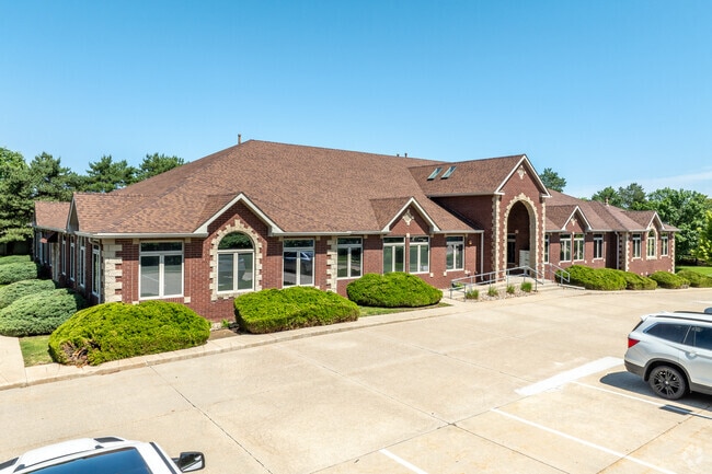
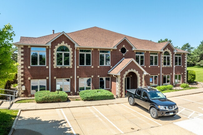
Property Record
1300 Nw 138Th St, Clive, IA 50325

NEARBY LISTINGS FOR SALE OR LEASE
Property Detail
1300 Nw 138Th St
Des Moines-West Des Moines, IA
Country Club Plat 11
291-00065485008
PARCEL B BEG E COR THN SWLY 109.42F SW 488.45F N363.6F E 473.39F TO POB LOT 2 COUNTRY CLUB PLAT 11
Officebuilding
Polk
X
Iowa
19153C0310F
2
2024
1.94 AC
2025
Western Suburbs
011203
Des Moines
20,412 SF
DEMOGRAPHICS near 1300 Nw 138Th St
1 Mile
3 Mile
5 Mile
2024 Total Population
4,677
76,155
155,313
2029 Population
5,074
87,482
174,888
Pop Growth 2024-2029
+ 8.49%
+ 14.87%
+ 12.60%
Average Age
43
37
38
2024 Total Households
1,767
30,883
63,379
HH Growth 2024-2029
+ 8.43%
+ 15.32%
+ 12.73%
Median Household Inc
$147,667
$93,981
$88,346
Avg Household Size
2.60
2.40
2.40
2024 Avg HH Vehicles
2.00
2.00
2.00
Median Home Value
$390,430
$301,381
$286,468
Median Year Built
1996
2003
1997
Nearby Places
Map Layers
Map Styles
 Street
 Aerial
- Restaurants
- Banks
- Shops
- Fitness
- Groceries
PUBLIC TRANSPORTATION
AIRPORT
Des Moines International
DRIVE
WALK
Distance
Des Moines International
22 min
12.3 mi
Freight Ports
Port Milwaukee
DRIVE
WALK
Distance
Port Milwaukee
427 min
383.4 mi
SALE & LEASE HISTORY
LISTING DATE
SALE/LEASE

Oct 01, 2021
For Sale
May 12, 2017
For Lease
Jul 23, 2020
For Sale
Nearby Properties
Address
Land Use
TOTAL SIZE
Lot Size
Zoning
Address
Land Use
TOTAL SIZE
Lot Size
Zoning
756,649 SF
67.99 AC
Address
Land Use
TOTAL SIZE
Lot Size
Zoning
472,476 SF
12.48 AC
PUD OFFICE
Address
Land Use
TOTAL SIZE
Lot Size
Zoning
18,093 SF
48.92 AC
Address
Land Use
TOTAL SIZE
Lot Size
Zoning
422,683 SF
46.57 AC
PCP
Address
Land Use
TOTAL SIZE
Lot Size
Zoning
Address
Land Use
TOTAL SIZE
Lot Size
Zoning
457,056 SF
26.01 AC
Address
Land Use
TOTAL SIZE
Lot Size
Zoning
37,325 SF
Address
Land Use
TOTAL SIZE
Lot Size
Zoning
2,864 SF
21.03 AC
Address
Land Use
TOTAL SIZE
Lot Size
Zoning
101,097 SF
30 AC
Address
Land Use
TOTAL SIZE
Lot Size
Zoning
189,660 SF
19.84 AC
Address
Land Use
TOTAL SIZE
Lot Size
Zoning
241,324 SF
21.67 AC
PUD B&C
Address
Land Use
TOTAL SIZE
Lot Size
Zoning
322,220 SF
7.61 AC
Address
Land Use
TOTAL SIZE
Lot Size
Zoning
275,227 SF
18.31 AC
PCP
Address
Land Use
TOTAL SIZE
Lot Size
Zoning
38,400 SF
13.12 AC
Address
Land Use
TOTAL SIZE
Lot Size
Zoning
3,358 SF
21 AC
Address
Land Use
TOTAL SIZE
Lot Size
Zoning
196,904 SF
26.10 AC
PUD
Address
Land Use
TOTAL SIZE
Lot Size
Zoning
387,456 SF
15.72 AC
PUD HD
Address
Land Use
TOTAL SIZE
Lot Size
Zoning
39,229 SF
22.75 AC
Address
Land Use
TOTAL SIZE
Lot Size
Zoning
46,250 SF
27.02 AC
Address
Land Use
TOTAL SIZE
Lot Size
Zoning
Address
Land Use
TOTAL SIZE
Lot Size
Zoning
22,093 SF
12.26 AC
Address
Land Use
TOTAL SIZE
Lot Size
Zoning
182,866 SF
10.21 AC
Address
Land Use
TOTAL SIZE
Lot Size
Zoning
243,217 SF
16.31 AC
PUD HD
Address
Land Use
TOTAL SIZE
Lot Size
Zoning
189,691 SF
27.03 AC
PCP
Address
Land Use
TOTAL SIZE
Lot Size
Zoning
5,635 SF
15.06 AC
Address
Land Use
TOTAL SIZE
Lot Size
Zoning
24,499 SF
5.75 AC
Address
Land Use
TOTAL SIZE
Lot Size
Zoning
2,168 SF
15.68 AC
Address
Land Use
TOTAL SIZE
Lot Size
Zoning
367,386 SF
24.31 AC
PUD
Address
Land Use
TOTAL SIZE
Lot Size
Zoning
341,024 SF
12.15 AC
RH
Address
Land Use
TOTAL SIZE
Lot Size
Zoning
4,590 SF
10.50 AC
The World's #1 Commercial Real Estate Marketplace
Connect with us
© 2026 CoStar Group
The information above has been obtained from sources believed reliable. While we do not doubt its accuracy we have not verified it and make no guarantee, warranty or representation about it. It is your responsibility to independently confirm its accuracy and completeness. Any projections, opinions, assumptions, or estimates used are for example only and do not represent the current or future performance of the property. The value of this transaction to you depends on tax and other factors which should be evaluated by your tax, financial, and legal advisors. You and your advisors should conduct a careful, independent investigation of the property to determine to your satisfaction the suitability of the property for your needs.