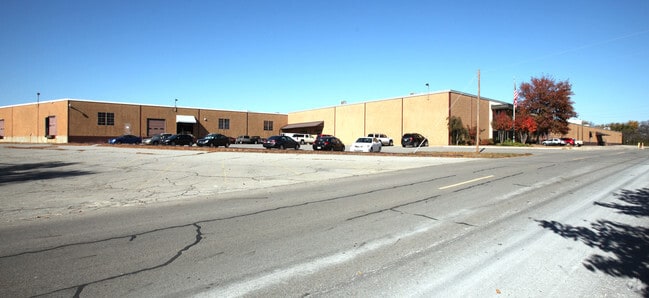
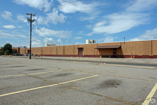
Property Record
1300 S 6Th St, Fort Smith, AR 72902

Property Detail
1300 S 6Th St
18883-0000-00736-00
PART N/2
Warehouse
SEBASTIAN
C and X Area of minimal flood hazard, usually depicted on FIRMs as above the 500-year flood level.
Arkansas
2025
20.06 AC
2025
Greater Ft Smith
001102
Fort Smith
470,412 SF
Fort Smith, AR-OK
NEARBY LISTINGS FOR SALE OR LEASE
DEMOGRAPHICS near 1300 S 6Th St
1 mile
3 mile
5 mile
2025 Total Population
2,991
40,233
77,552
2030 Population
3,072
41,066
78,714
Pop Growth 2025-2030
+ 2.71%
+ 2.07%
+ 1.50%
Average Age
40
39
38
2025 Total Households
1,317
16,672
31,196
HH Growth 2025-2030
+ 2.81%
+ 2.03%
+ 1.48%
Median Household Inc
$34,515
$45,935
$50,680
Avg Household Size
2.10
2.30
2.40
2025 Avg HH Vehicles
1.00
2.00
2.00
Median Home Value
$124,830
$145,899
$159,404
Median Year Built
1953
1965
1972
Nearby Places
Map Layers
Map Styles
 Street
 Aerial
Layers
 Traffic
 Biking
Places
Listings with unknown addresses are not visible on the map
- Restaurants
- Banks
- Shops
- Fitness
- Groceries
PUBLIC TRANSPORTATION
AIRPORT
Fort Smith Regional
Drive
Walk
Distance
Fort Smith Regional
20 min
7.5 mi
Nearby Properties
Address
Land Use
TOTAL SIZE
Lot Size
Zoning
Address
Land Use
TOTAL SIZE
Lot Size
Zoning
34,852 SF
17.68 AC
Address
Land Use
TOTAL SIZE
Lot Size
Zoning
53,104 SF
7.29 AC
Address
Land Use
TOTAL SIZE
Lot Size
Zoning
276,870 SF
36.85 AC
Address
Land Use
TOTAL SIZE
Lot Size
Zoning
154,417 SF
8.08 AC
Address
Land Use
TOTAL SIZE
Lot Size
Zoning
198,302 SF
42.39 AC
Address
Land Use
TOTAL SIZE
Lot Size
Zoning
275,083 SF
11.29 AC
Address
Land Use
TOTAL SIZE
Lot Size
Zoning
178,951 SF
1.92 AC
Address
Land Use
TOTAL SIZE
Lot Size
Zoning
202,092 SF
16.25 AC
Address
Land Use
TOTAL SIZE
Lot Size
Zoning
67,084 SF
0.62 AC
Address
Land Use
TOTAL SIZE
Lot Size
Zoning
49,702 SF
1.36 AC
Address
Land Use
TOTAL SIZE
Lot Size
Zoning
237,553 SF
15.38 AC
Address
Land Use
TOTAL SIZE
Lot Size
Zoning
60,146 SF
0.81 AC
Address
Land Use
TOTAL SIZE
Lot Size
Zoning
108,519 SF
13.38 AC
Address
Land Use
TOTAL SIZE
Lot Size
Zoning
54,697 SF
7.87 AC
Address
Land Use
TOTAL SIZE
Lot Size
Zoning
94,409 SF
2.81 AC
Address
Land Use
TOTAL SIZE
Lot Size
Zoning
71,047 SF
0.45 AC
Address
Land Use
TOTAL SIZE
Lot Size
Zoning
539,722 SF
41.86 AC
Address
Land Use
TOTAL SIZE
Lot Size
Zoning
238,911 SF
23.57 AC
Address
Land Use
TOTAL SIZE
Lot Size
Zoning
61,902 SF
6.53 AC
Address
Land Use
TOTAL SIZE
Lot Size
Zoning
99,151 SF
7.70 AC
Address
Land Use
TOTAL SIZE
Lot Size
Zoning
2,527 SF
15.54 AC
Address
Land Use
TOTAL SIZE
Lot Size
Zoning
26,000 SF
0.37 AC
Address
Land Use
TOTAL SIZE
Lot Size
Zoning
62,463 SF
1.38 AC
Address
Land Use
TOTAL SIZE
Lot Size
Zoning
44,103 SF
4.81 AC
Address
Land Use
TOTAL SIZE
Lot Size
Zoning
100,448 SF
5.67 AC
Address
Land Use
TOTAL SIZE
Lot Size
Zoning
66,096 SF
10.69 AC
Address
Land Use
TOTAL SIZE
Lot Size
Zoning
91,333 SF
8.90 AC
Address
Land Use
TOTAL SIZE
Lot Size
Zoning
67,845 SF
6.96 AC
Address
Land Use
TOTAL SIZE
Lot Size
Zoning
27,970 SF
1.36 AC
The World's #1 Commercial Real Estate Marketplace
Connect with us
© 2026 CoStar Group
The information above has been obtained from sources believed reliable. While we do not doubt its accuracy we have not verified it and make no guarantee, warranty or representation about it. It is your responsibility to independently confirm its accuracy and completeness. Any projections, opinions, assumptions, or estimates used are for example only and do not represent the current or future performance of the property. The value of this transaction to you depends on tax and other factors which should be evaluated by your tax, financial, and legal advisors. You and your advisors should conduct a careful, independent investigation of the property to determine to your satisfaction the suitability of the property for your needs.