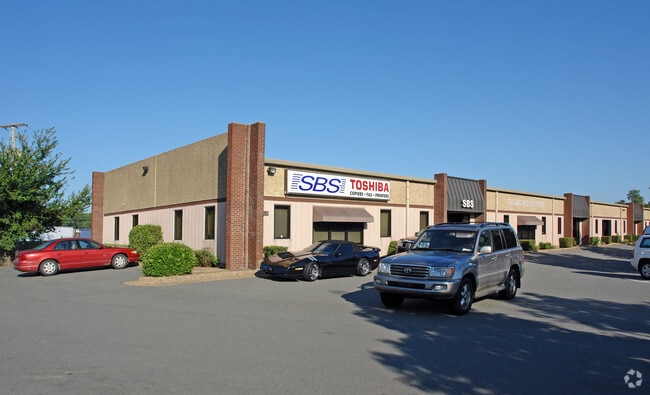
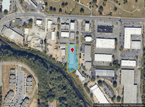
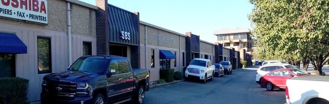
Property Record
1300 Westpark Dr, Little Rock, AR 72204
NEARBY LISTINGS FOR SALE OR LEASE
Property Detail
1300 Westpark Dr
Little Rock-North Little Rock-Conway, AR
West Park Dev
44L-109-00-001-04
BEING A REPLAT OF PT OF BLK AR BLK AR BEING A REPLAT OF BLK A
Industrialgeneral
Pulaski
AE
Arkansas
05119C0451H
6
2025
1.23 AC
2025
Midtown
002102
Little Rock/N Little Rock
13,247 SF
DEMOGRAPHICS near 1300 Westpark Dr
1 Mile
3 Mile
5 Mile
2024 Total Population
8,790
77,164
152,571
2029 Population
8,765
77,562
153,377
Pop Growth 2024-2029
(0.28%)
+ 0.52%
+ 0.53%
Average Age
39
39
39
2024 Total Households
4,039
34,415
68,696
HH Growth 2024-2029
(0.37%)
+ 0.55%
+ 0.52%
Median Household Inc
$42,009
$48,282
$49,344
Avg Household Size
2.10
2.10
2.10
2024 Avg HH Vehicles
1.00
2.00
2.00
Median Home Value
$136,232
$169,874
$177,386
Median Year Built
1968
1968
1974
Nearby Places
- Restaurants
- Banks
- Shops
- Fitness
- Groceries
PUBLIC TRANSPORTATION
COMMUTER RAIL
DRIVE
WALK
Distance
9 min
4.6 mi
AIRPORT
Bill and Hillary Clinton Ntl/Adams Field
DRIVE
WALK
Distance
Bill and Hillary Clinton Ntl/Adams Field
16 min
9.3 mi
SALE & LEASE HISTORY
LISTING DATE
SALE/LEASE

Nov 13, 2019
For Lease
Jan 06, 2020
For Sale
Nearby Properties
Address
Land Use
TOTAL SIZE
Lot Size
Zoning
Address
Land Use
TOTAL SIZE
Lot Size
Zoning
4,400,000 SF
27.97 AC
Address
Land Use
TOTAL SIZE
Lot Size
Zoning
1,665,090 SF
34.75 AC
Address
Land Use
TOTAL SIZE
Lot Size
Zoning
1,909,430 SF
29.12 AC
Address
Land Use
TOTAL SIZE
Lot Size
Zoning
802,734 SF
22.99 AC
Address
Land Use
TOTAL SIZE
Lot Size
Zoning
956,566 SF
70.39 AC
Address
Land Use
TOTAL SIZE
Lot Size
Zoning
475,613 SF
10.14 AC
Address
Land Use
TOTAL SIZE
Lot Size
Zoning
227,729 SF
36.49 AC
Address
Land Use
TOTAL SIZE
Lot Size
Zoning
603,434 SF
10.21 AC
Address
Land Use
TOTAL SIZE
Lot Size
Zoning
297,814 SF
86.09 AC
Address
Land Use
TOTAL SIZE
Lot Size
Zoning
576 SF
62.63 AC
Address
Land Use
TOTAL SIZE
Lot Size
Zoning
145,580 SF
19.89 AC
Address
Land Use
TOTAL SIZE
Lot Size
Zoning
35,086 SF
6.48 AC
Address
Land Use
TOTAL SIZE
Lot Size
Zoning
140,675 SF
Address
Land Use
TOTAL SIZE
Lot Size
Zoning
130,800 SF
7.78 AC
Address
Land Use
TOTAL SIZE
Lot Size
Zoning
168,041 SF
29.22 AC
Address
Land Use
TOTAL SIZE
Lot Size
Zoning
173,209 SF
26.54 AC
Address
Land Use
TOTAL SIZE
Lot Size
Zoning
19,142 SF
5.54 AC
Address
Land Use
TOTAL SIZE
Lot Size
Zoning
318,188 SF
8.86 AC
Address
Land Use
TOTAL SIZE
Lot Size
Zoning
63,244 SF
14.21 AC
Address
Land Use
TOTAL SIZE
Lot Size
Zoning
404,617 SF
9.51 AC
Address
Land Use
TOTAL SIZE
Lot Size
Zoning
29,976 SF
27.38 AC
Address
Land Use
TOTAL SIZE
Lot Size
Zoning
185,873 SF
Address
Land Use
TOTAL SIZE
Lot Size
Zoning
78,004 SF
4.44 AC
Address
Land Use
TOTAL SIZE
Lot Size
Zoning
48,470 SF
26.37 AC
Address
Land Use
TOTAL SIZE
Lot Size
Zoning
14,902 SF
5.04 AC
Address
Land Use
TOTAL SIZE
Lot Size
Zoning
88,687 SF
1.67 AC
Address
Land Use
TOTAL SIZE
Lot Size
Zoning
52,577 SF
Address
Land Use
TOTAL SIZE
Lot Size
Zoning
287,961 SF
168.06 AC
Address
Land Use
TOTAL SIZE
Lot Size
Zoning
33,992 SF
13.15 AC
Address
Land Use
TOTAL SIZE
Lot Size
Zoning
326,736 SF
7.21 AC
The World's #1 Commercial Real Estate Marketplace
Connect with us
© 2025 CoStar Group
The information above has been obtained from sources believed reliable. While we do not doubt its accuracy we have not verified it and make no guarantee, warranty or representation about it. It is your responsibility to independently confirm its accuracy and completeness. Any projections, opinions, assumptions, or estimates used are for example only and do not represent the current or future performance of the property. The value of this transaction to you depends on tax and other factors which should be evaluated by your tax, financial, and legal advisors. You and your advisors should conduct a careful, independent investigation of the property to determine to your satisfaction the suitability of the property for your needs.