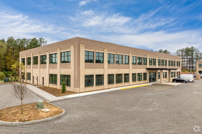
Property Record
1300 Wilkes Ridge Dr, Richmond, VA 23233
Current Lease Availabilities
NEARBY LISTINGS FOR SALE OR LEASE
Property Detail
1300 Wilkes Ridge Dr
Richmond, VA
WEST CREEK PHASE 2 4.139AC PAR 2 OUT OF 58-3-2-89-A #24-0634 PCF 147
59-3-2-89A2
Goochland
Multipleuses
Virginia
2025
4.14 AC
2025
West Creek
400102
Richmond VA
DEMOGRAPHICS near 1300 Wilkes Ridge Dr
1 Mile
3 Mile
5 Mile
2024 Total Population
4,701
41,072
93,783
2029 Population
4,940
42,012
95,076
Pop Growth 2024-2029
+ 5.08%
+ 2.29%
+ 1.38%
Average Age
41
40
41
2024 Total Households
1,759
15,324
36,115
HH Growth 2024-2029
+ 5.57%
+ 2.67%
+ 1.56%
Median Household Inc
$120,324
$129,048
$122,060
Avg Household Size
2.60
2.60
2.50
2024 Avg HH Vehicles
2.00
2.00
2.00
Median Home Value
$650,758
$529,529
$469,496
Median Year Built
2005
1998
1994
Nearby Places
Map Layers
Map Styles
 Street
 Aerial
- Restaurants
- Banks
- Shops
- Fitness
- Groceries
PUBLIC TRANSPORTATION
AIRPORT
Richmond International
DRIVE
WALK
Distance
Richmond International
40 min
25.1 mi
Freight Ports
Virginia Port Authority - Richmond
DRIVE
WALK
Distance
Virginia Port Authority - Richmond
38 min
23.4 mi
Nearby Properties
Address
Land Use
TOTAL SIZE
Lot Size
Zoning
Address
Land Use
TOTAL SIZE
Lot Size
Zoning
10,290 SF
56.53 AC
B-3C
Address
Land Use
TOTAL SIZE
Lot Size
Zoning
3,300 SF
286.94 AC
M1-INDUS/L
Address
Land Use
TOTAL SIZE
Lot Size
Zoning
93.75 AC
M1-INDUS/L
Address
Land Use
TOTAL SIZE
Lot Size
Zoning
37.36 AC
R-5C
Address
Land Use
TOTAL SIZE
Lot Size
Zoning
22.47 AC
M1-INDUS/L
Address
Land Use
TOTAL SIZE
Lot Size
Zoning
227,483 SF
12.10 AC
M1-INDUS/L
Address
Land Use
TOTAL SIZE
Lot Size
Zoning
112,224 SF
20.53 AC
MIXE
Address
Land Use
TOTAL SIZE
Lot Size
Zoning
57,104 SF
0.02 AC
UMUC
Address
Land Use
TOTAL SIZE
Lot Size
Zoning
3,077 SF
19.89 AC
M1-INDUS/L
Address
Land Use
TOTAL SIZE
Lot Size
Zoning
340 SF
23.32 AC
MIXE
Address
Land Use
TOTAL SIZE
Lot Size
Zoning
282,400 SF
18.71 AC
MIXE
Address
Land Use
TOTAL SIZE
Lot Size
Zoning
289,752 SF
24.72 AC
R-5C
Address
Land Use
TOTAL SIZE
Lot Size
Zoning
352,296 SF
23.62 AC
R-5
Address
Land Use
TOTAL SIZE
Lot Size
Zoning
243,000 SF
130.85 AC
M1-INDUS/L
Address
Land Use
TOTAL SIZE
Lot Size
Zoning
5,590 SF
11.54 AC
B-2C
Address
Land Use
TOTAL SIZE
Lot Size
Zoning
271,263 SF
18.81 AC
MIXE
Address
Land Use
TOTAL SIZE
Lot Size
Zoning
179,920 SF
16.23 AC
R-5
Address
Land Use
TOTAL SIZE
Lot Size
Zoning
55,769 SF
14.13 AC
MIXE
Address
Land Use
TOTAL SIZE
Lot Size
Zoning
111,487 SF
2.92 AC
B-2C
Address
Land Use
TOTAL SIZE
Lot Size
Zoning
23,378 SF
0.02 AC
UMUC
Address
Land Use
TOTAL SIZE
Lot Size
Zoning
164,680 SF
33.86 AC
MIXE
Address
Land Use
TOTAL SIZE
Lot Size
Zoning
20,864 SF
15.28 AC
MIXE
Address
Land Use
TOTAL SIZE
Lot Size
Zoning
176,520 SF
17.61 AC
R-5
Address
Land Use
TOTAL SIZE
Lot Size
Zoning
10,282 SF
2.13 AC
B-3C
Address
Land Use
TOTAL SIZE
Lot Size
Zoning
97,890 SF
9.87 AC
R-6
Address
Land Use
TOTAL SIZE
Lot Size
Zoning
58,446 SF
12.71 AC
B-3C
Address
Land Use
TOTAL SIZE
Lot Size
Zoning
187,283 SF
5.22 AC
B-2C
Address
Land Use
TOTAL SIZE
Lot Size
Zoning
74,305 SF
6.05 AC
M1-INDUS/L
Address
Land Use
TOTAL SIZE
Lot Size
Zoning
124,140 SF
6.10 AC
R-6C
Address
Land Use
TOTAL SIZE
Lot Size
Zoning
78,400 SF
29.68 AC
A-1
The World's #1 Commercial Real Estate Marketplace
Connect with us
© 2026 CoStar Group
The information above has been obtained from sources believed reliable. While we do not doubt its accuracy we have not verified it and make no guarantee, warranty or representation about it. It is your responsibility to independently confirm its accuracy and completeness. Any projections, opinions, assumptions, or estimates used are for example only and do not represent the current or future performance of the property. The value of this transaction to you depends on tax and other factors which should be evaluated by your tax, financial, and legal advisors. You and your advisors should conduct a careful, independent investigation of the property to determine to your satisfaction the suitability of the property for your needs.