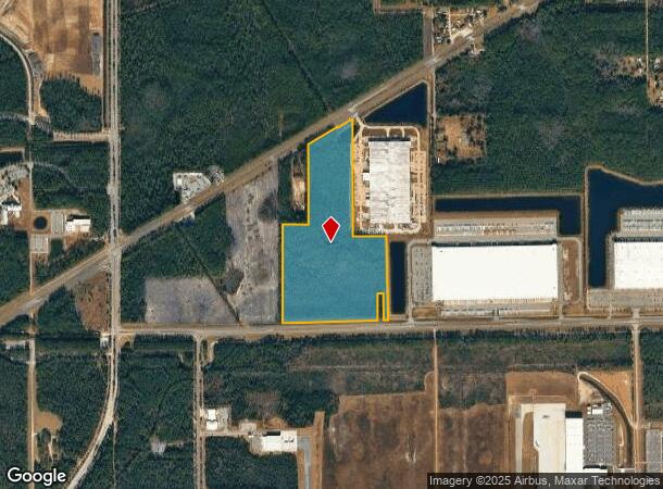
Property Record
0 Normandy Blvd, Jacksonville, FL 32221
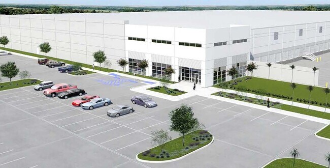

Current Lease Availabilities
NEARBY LISTINGS FOR SALE OR LEASE
-
-
View all Jacksonville listings for lease on LoopNet.com
Property Detail
0 Normandy Blvd
Jacksonville, FL
Jax Heights Sec
002209-0010
5-93 11-3S-24E 48.73 JACKSONVILLE HEIGHTS PT TRACTS 4,5 LYING S OF STATE RD 228, 11 TO 16(EX O/RS 17077-1885, 18547-998, 18638-1239) BLK 3
Vacantlandnec
Duval
X
Florida
12019C0055E
48.73 AC
0
Riverside
2025
Jacksonville (Florida)
011904
DEMOGRAPHICS near 0 Normandy Blvd
1 Mile
3 Mile
5 Mile
2024 Total Population
268
8,406
48,210
2029 Population
288
9,051
51,873
Pop Growth 2024-2029
+ 7.46%
+ 7.67%
+ 7.60%
Average Age
40
37
37
2024 Total Households
99
2,915
17,054
HH Growth 2024-2029
+ 7.07%
+ 7.65%
+ 7.69%
Median Household Inc
$72,499
$78,765
$73,209
Avg Household Size
2.70
2.90
2.80
2024 Avg HH Vehicles
2.00
2.00
2.00
Median Home Value
$260,810
$248,136
$258,058
Median Year Built
1998
2007
2006
Nearby Places
Map Layers
Map Styles
 Street
 Aerial
- Restaurants
- Banks
- Shops
- Fitness
- Groceries
PUBLIC TRANSPORTATION
AIRPORT
Jacksonville International
DRIVE
WALK
Distance
Jacksonville International
41 min
25.8 mi
Freight Ports
Jacksonville Port
DRIVE
WALK
Distance
Jacksonville Port
34 min
19.0 mi
Nearby Properties
Address
Land Use
TOTAL SIZE
Lot Size
Zoning
Address
Land Use
TOTAL SIZE
Lot Size
Zoning
1,710,467 SF
5,837.66 AC
PUD
Address
Land Use
TOTAL SIZE
Lot Size
Zoning
1,020,863 SF
85.89 AC
PUD
Address
Land Use
TOTAL SIZE
Lot Size
Zoning
1,014,416 SF
80.58 AC
PUD
Address
Land Use
TOTAL SIZE
Lot Size
Zoning
1,043,069 SF
62.83 AC
PUD
Address
Land Use
TOTAL SIZE
Lot Size
Zoning
239,891 SF
21.95 AC
CRO
Address
Land Use
TOTAL SIZE
Lot Size
Zoning
557,137 SF
40.70 AC
PUD
Address
Land Use
TOTAL SIZE
Lot Size
Zoning
410,800 SF
35.51 AC
PUD
Address
Land Use
TOTAL SIZE
Lot Size
Zoning
221,429 SF
15.42 AC
PUD
Address
Land Use
TOTAL SIZE
Lot Size
Zoning
223,066 SF
2,016.91 AC
PUD
Address
Land Use
TOTAL SIZE
Lot Size
Zoning
280,207 SF
37.53 AC
PUD
Address
Land Use
TOTAL SIZE
Lot Size
Zoning
312,832 SF
46.20 AC
PUD
Address
Land Use
TOTAL SIZE
Lot Size
Zoning
206,164 SF
53.84 AC
PUD
Address
Land Use
TOTAL SIZE
Lot Size
Zoning
245,626 SF
202.62 AC
PUD
Address
Land Use
TOTAL SIZE
Lot Size
Zoning
58,632 SF
582.79 AC
PUD
Address
Land Use
TOTAL SIZE
Lot Size
Zoning
88,000 SF
11.28 AC
CCG-1
Address
Land Use
TOTAL SIZE
Lot Size
Zoning
132,504 SF
47.95 AC
PBF-2
Address
Land Use
TOTAL SIZE
Lot Size
Zoning
55,621 SF
125.96 AC
PUD
Address
Land Use
TOTAL SIZE
Lot Size
Zoning
392,387 SF
115.92 AC
PUD
Address
Land Use
TOTAL SIZE
Lot Size
Zoning
133,046 SF
204.49 AC
PUD
Address
Land Use
TOTAL SIZE
Lot Size
Zoning
292,154 SF
18.68 AC
PUD
Address
Land Use
TOTAL SIZE
Lot Size
Zoning
237,991 SF
11.82 AC
PUD
Address
Land Use
TOTAL SIZE
Lot Size
Zoning
6,792 SF
53.56 AC
PUD
Address
Land Use
TOTAL SIZE
Lot Size
Zoning
365.57 AC
PUD
Address
Land Use
TOTAL SIZE
Lot Size
Zoning
108,217 SF
178.52 AC
PBF-1
Address
Land Use
TOTAL SIZE
Lot Size
Zoning
198,713 SF
26.59 AC
PUD
Address
Land Use
TOTAL SIZE
Lot Size
Zoning
10,460 SF
305.51 AC
PUD
Address
Land Use
TOTAL SIZE
Lot Size
Zoning
528.99 AC
PUD
Address
Land Use
TOTAL SIZE
Lot Size
Zoning
404.50 AC
PUD
Address
Land Use
TOTAL SIZE
Lot Size
Zoning
13.29 AC
PUD
Address
Land Use
TOTAL SIZE
Lot Size
Zoning
161.20 AC
PUD
The World's #1 Commercial Real Estate Marketplace
Connect with us
© 2025 CoStar Group
The information above has been obtained from sources believed reliable. While we do not doubt its accuracy we have not verified it and make no guarantee, warranty or representation about it. It is your responsibility to independently confirm its accuracy and completeness. Any projections, opinions, assumptions, or estimates used are for example only and do not represent the current or future performance of the property. The value of this transaction to you depends on tax and other factors which should be evaluated by your tax, financial, and legal advisors. You and your advisors should conduct a careful, independent investigation of the property to determine to your satisfaction the suitability of the property for your needs.