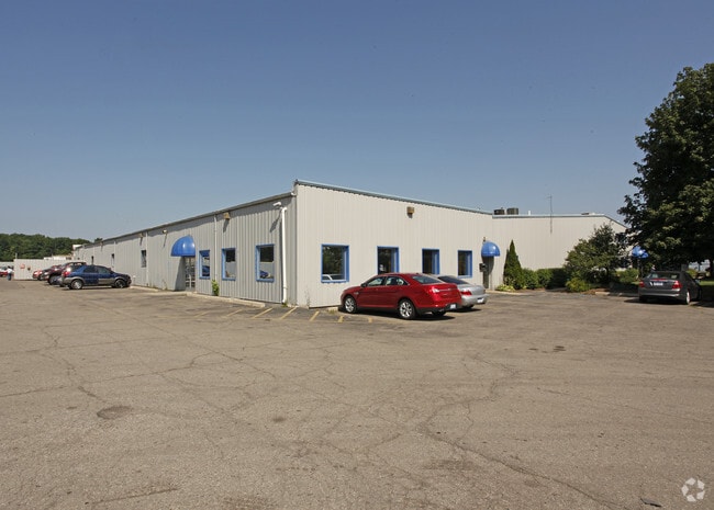
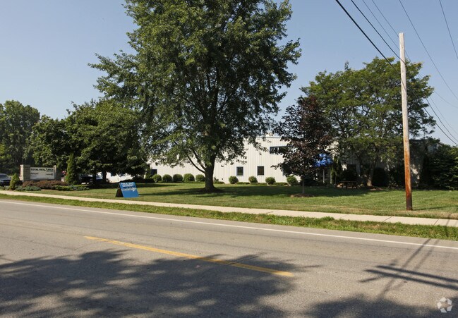
Property Record
13000 Haggerty Rd, Van Buren Township, MI 48111

NEARBY LISTINGS FOR SALE OR LEASE
Property Detail
13000 Haggerty Rd
83-095-99-0003-708
*24FF1B1B,FF1B2A1A2 - - FF1B2B1B* PT OF SW 1/4 SEC 24 T3S R8E DESC AS BEG AT THE SW COR OF SEC 24 - - TH N00 20 35W 933.2 FT- TH S89 46 03E 561.35 FT- TH N00 09 18W 568.66 FT- TH S86 50 59E 144.14 FT- TH S86 50 20E 237.3 FT- TH S00 21 16E 515 FT- TH
Industrialgeneral
Wayne
X
Michigan
26163C0354E
0003
2025
32.02 AC
2025
Airport District
588400
Detroit
62,650 SF
Detroit-Warren-Dearborn, MI
DEMOGRAPHICS near 13000 Haggerty Rd
1 Mile
3 Mile
5 Mile
2024 Total Population
1,860
25,302
50,272
2029 Population
1,757
24,238
48,314
Pop Growth 2024-2029
(5.54%)
(4.21%)
(3.89%)
Average Age
42
41
40
2024 Total Households
720
10,804
20,901
HH Growth 2024-2029
(5.56%)
(4.20%)
(3.92%)
Median Household Inc
$75,868
$68,742
$68,025
Avg Household Size
2.50
2.30
2.40
2024 Avg HH Vehicles
2.00
2.00
2.00
Median Home Value
$252,727
$216,553
$216,709
Median Year Built
1973
1977
1977
Nearby Places
Map Layers
Map Styles
 Street
 Aerial
- Restaurants
- Banks
- Shops
- Fitness
- Groceries
PUBLIC TRANSPORTATION
AIRPORT
Detroit Metro Wayne County
DRIVE
WALK
Distance
Detroit Metro Wayne County
17 min
8.1 mi
Windsor International
DRIVE
WALK
Distance
Windsor International
54 min
35.5 mi
Freight Ports
DRIVE
WALK
Distance
63 min
49.8 mi
Nearby Properties
Address
Land Use
TOTAL SIZE
Lot Size
Zoning
Address
Land Use
TOTAL SIZE
Lot Size
Zoning
739,289 SF
238.69 AC
AG
Address
Land Use
TOTAL SIZE
Lot Size
Zoning
919,978 SF
65.96 AC
MT IND
Address
Land Use
TOTAL SIZE
Lot Size
Zoning
461,566 SF
50.13 AC
RM MULT
Address
Land Use
TOTAL SIZE
Lot Size
Zoning
495,062 SF
52.40 AC
M1 LIG
Address
Land Use
TOTAL SIZE
Lot Size
Zoning
1,141,765 SF
154.21 AC
M2-GEN
Address
Land Use
TOTAL SIZE
Lot Size
Zoning
357,286 SF
36.79 AC
RM MULT
Address
Land Use
TOTAL SIZE
Lot Size
Zoning
432.42 AC
M2 GEN
Address
Land Use
TOTAL SIZE
Lot Size
Zoning
1,071,200 SF
85.27 AC
M1 LIG
Address
Land Use
TOTAL SIZE
Lot Size
Zoning
199,922 SF
30.86 AC
M2-GEN
Address
Land Use
TOTAL SIZE
Lot Size
Zoning
462,840 SF
45.66 AC
PDA
Address
Land Use
TOTAL SIZE
Lot Size
Zoning
630,828 SF
62.51 AC
R1B
Address
Land Use
TOTAL SIZE
Lot Size
Zoning
659,516 SF
46.15 AC
MT IND
Address
Land Use
TOTAL SIZE
Lot Size
Zoning
437,836 SF
28.75 AC
M1 LIG
Address
Land Use
TOTAL SIZE
Lot Size
Zoning
161,794 SF
17.73 AC
RM MULT
Address
Land Use
TOTAL SIZE
Lot Size
Zoning
132,528 SF
5.91 AC
C2 EXT
Address
Land Use
TOTAL SIZE
Lot Size
Zoning
87,000 SF
18.02 AC
Address
Land Use
TOTAL SIZE
Lot Size
Zoning
25,002 SF
7.91 AC
C1 GEN
Address
Land Use
TOTAL SIZE
Lot Size
Zoning
199,776 SF
39.34 AC
C2 EXT
Address
Land Use
TOTAL SIZE
Lot Size
Zoning
191,446 SF
22.76 AC
C2 EXT
Address
Land Use
TOTAL SIZE
Lot Size
Zoning
198,304 SF
23.96 AC
C2 EXT
Address
Land Use
TOTAL SIZE
Lot Size
Zoning
3,184 SF
41.02 AC
Address
Land Use
TOTAL SIZE
Lot Size
Zoning
M1-LIG
Address
Land Use
TOTAL SIZE
Lot Size
Zoning
76,763 SF
9.63 AC
M1 LIG
Address
Land Use
TOTAL SIZE
Lot Size
Zoning
119,319 SF
10.23 AC
RM MULT
Address
Land Use
TOTAL SIZE
Lot Size
Zoning
62,633 SF
6.39 AC
C LOC
Address
Land Use
TOTAL SIZE
Lot Size
Zoning
69,415 SF
11.32 AC
C2 EXT
Address
Land Use
TOTAL SIZE
Lot Size
Zoning
338,896 SF
14.35 AC
M2-GEN
Address
Land Use
TOTAL SIZE
Lot Size
Zoning
282,628 SF
22.93 AC
M1 LIG
Address
Land Use
TOTAL SIZE
Lot Size
Zoning
116,377 SF
26.19 AC
M1 LIG
Address
Land Use
TOTAL SIZE
Lot Size
Zoning
102,395 SF
11 AC
RM MULT
The World's #1 Commercial Real Estate Marketplace
Connect with us
© 2026 CoStar Group
The information above has been obtained from sources believed reliable. While we do not doubt its accuracy we have not verified it and make no guarantee, warranty or representation about it. It is your responsibility to independently confirm its accuracy and completeness. Any projections, opinions, assumptions, or estimates used are for example only and do not represent the current or future performance of the property. The value of this transaction to you depends on tax and other factors which should be evaluated by your tax, financial, and legal advisors. You and your advisors should conduct a careful, independent investigation of the property to determine to your satisfaction the suitability of the property for your needs.