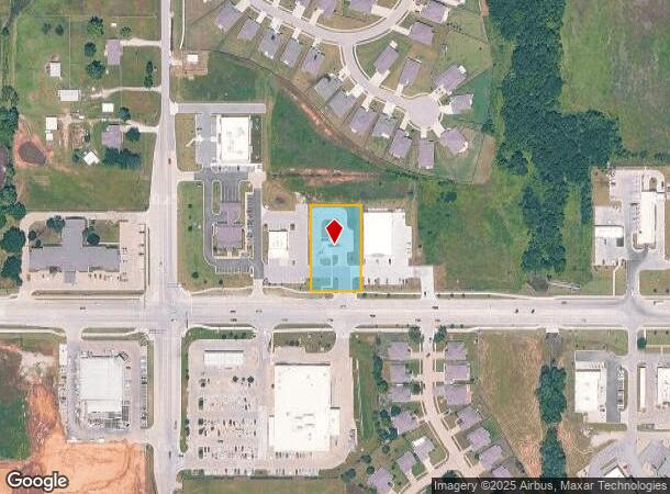
Property Record
13001 E 116 St N, Owasso, OK 74055

NEARBY LISTINGS FOR SALE OR LEASE
Property Detail
13001 E 116 St N
Tulsa
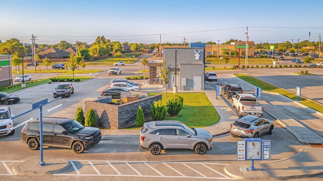
Cvp-Owasso Db
Tulsa, OK
LOT 1 BLOCK 1
61013-14-04-46870
Tulsa
Restaurantbuilding
Oklahoma
2025
1
2025
0.83 AC
005812
Northeast Tulsa
976 SF
DEMOGRAPHICS near 13001 E 116 St N
1 Mile
3 Mile
5 Mile
2024 Total Population
2,942
33,451
66,967
2029 Population
3,036
34,897
70,256
Pop Growth 2024-2029
+ 3.20%
+ 4.32%
+ 4.91%
Average Age
37
38
38
2024 Total Households
1,121
12,101
24,718
HH Growth 2024-2029
+ 3.30%
+ 4.37%
+ 4.86%
Median Household Inc
$64,218
$80,892
$78,330
Avg Household Size
2.60
2.70
2.70
2024 Avg HH Vehicles
2.00
2.00
2.00
Median Home Value
$191,258
$211,774
$218,997
Median Year Built
2004
2001
1999
Nearby Places
Map Layers
Map Styles
 Street
 Aerial
- Restaurants
- Banks
- Shops
- Fitness
- Groceries
PUBLIC TRANSPORTATION
AIRPORT
Tulsa International
DRIVE
WALK
Distance
Tulsa International
16 min
11.6 mi
Freight Ports
Tulsa Port Of Catoosa
DRIVE
WALK
Distance
Tulsa Port Of Catoosa
19 min
14.4 mi
SALE & LEASE HISTORY
LISTING DATE
SALE/LEASE

Jul 24, 2025
For Sale
Jan 12, 2023
For Sale
Nearby Properties
Address
Land Use
TOTAL SIZE
Lot Size
Zoning
Address
Land Use
TOTAL SIZE
Lot Size
Zoning
299,471 SF
64.32 AC
AG
Address
Land Use
TOTAL SIZE
Lot Size
Zoning
111,792 SF
12.43 AC
OM
Address
Land Use
TOTAL SIZE
Lot Size
Zoning
47,798 SF
5.13 AC
CS
Address
Land Use
TOTAL SIZE
Lot Size
Zoning
115,952 SF
19.30 AC
RS3
Address
Land Use
TOTAL SIZE
Lot Size
Zoning
138,427 SF
8.90 AC
OM
Address
Land Use
TOTAL SIZE
Lot Size
Zoning
105,098 SF
18.22 AC
RS2
Address
Land Use
TOTAL SIZE
Lot Size
Zoning
43,882 SF
10 AC
AG
Address
Land Use
TOTAL SIZE
Lot Size
Zoning
270,386 SF
14.65 AC
RM
Address
Land Use
TOTAL SIZE
Lot Size
Zoning
246,823 SF
12.77 AC
Address
Land Use
TOTAL SIZE
Lot Size
Zoning
24,164 SF
11.81 AC
NCU
Address
Land Use
TOTAL SIZE
Lot Size
Zoning
31,502 SF
11.08 AC
AG
Address
Land Use
TOTAL SIZE
Lot Size
Zoning
22,679 SF
0.77 AC
CBD
Address
Land Use
TOTAL SIZE
Lot Size
Zoning
17,600 SF
15.04 AC
RE
Address
Land Use
TOTAL SIZE
Lot Size
Zoning
226,062 SF
11.78 AC
RM2
Address
Land Use
TOTAL SIZE
Lot Size
Zoning
101,776 SF
9.96 AC
CS
Address
Land Use
TOTAL SIZE
Lot Size
Zoning
40,100 SF
4.36 AC
IM
Address
Land Use
TOTAL SIZE
Lot Size
Zoning
40,822 SF
11.39 AC
AG
Address
Land Use
TOTAL SIZE
Lot Size
Zoning
40,206 SF
3.72 AC
RS3
Address
Land Use
TOTAL SIZE
Lot Size
Zoning
178,815 SF
18.21 AC
CS
Address
Land Use
TOTAL SIZE
Lot Size
Zoning
28,400 SF
12.66 AC
AG
Address
Land Use
TOTAL SIZE
Lot Size
Zoning
42,211 SF
0.65 AC
RS3
Address
Land Use
TOTAL SIZE
Lot Size
Zoning
133,301 SF
21.09 AC
RS3
Address
Land Use
TOTAL SIZE
Lot Size
Zoning
24,435 SF
4.41 AC
RE
Address
Land Use
TOTAL SIZE
Lot Size
Zoning
208,326 SF
16.36 AC
CS
Address
Land Use
TOTAL SIZE
Lot Size
Zoning
3,679 SF
33.74 AC
AG
Address
Land Use
TOTAL SIZE
Lot Size
Zoning
31,781 SF
4.60 AC
AG
Address
Land Use
TOTAL SIZE
Lot Size
Zoning
103,300 SF
13.81 AC
CS
Address
Land Use
TOTAL SIZE
Lot Size
Zoning
33,157 SF
3.82 AC
AGR
Address
Land Use
TOTAL SIZE
Lot Size
Zoning
8,334 SF
46.11 AC
AG
Address
Land Use
TOTAL SIZE
Lot Size
Zoning
102,100 SF
10.55 AC
CS
The World's #1 Commercial Real Estate Marketplace
Connect with us
© 2026 CoStar Group
The information above has been obtained from sources believed reliable. While we do not doubt its accuracy we have not verified it and make no guarantee, warranty or representation about it. It is your responsibility to independently confirm its accuracy and completeness. Any projections, opinions, assumptions, or estimates used are for example only and do not represent the current or future performance of the property. The value of this transaction to you depends on tax and other factors which should be evaluated by your tax, financial, and legal advisors. You and your advisors should conduct a careful, independent investigation of the property to determine to your satisfaction the suitability of the property for your needs.