Property Record
13005 9Th St, Bowie, MD 20720

Save to a Folder
{{folder.Name}}
{{folder.ListingIds.length}} Properties
{{folder.ListingIds.length}} Property
Create a New Folder
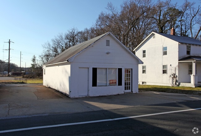
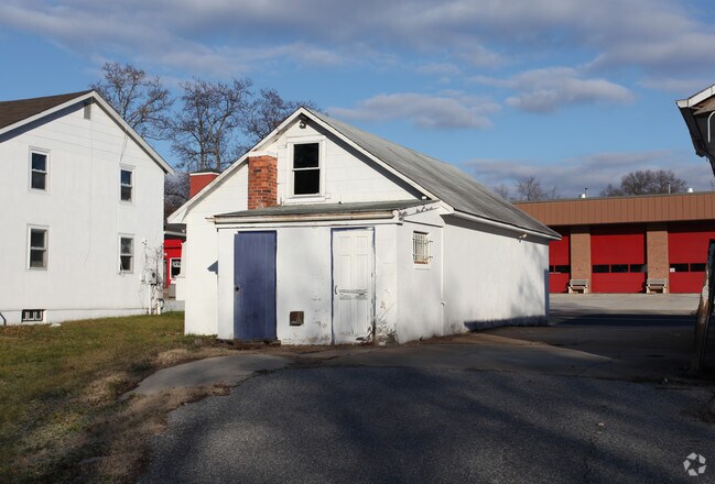
Property Detail
13005 9Th St
Commercialacreage
Prince Georges
CN
Maryland
B and X Area of moderate flood hazard, usually the area between the limits of the 100-year and 500-year floods.
0.32 AC
2024
Bowie
2025
Washington, DC
800410
Washington-Arlington-Alexandria, DC-VA-MD-WV
3,700 SF
14-1594027
NEARBY LISTINGS FOR SALE OR LEASE
DEMOGRAPHICS near 13005 9Th St
1 mile
3 mile
5 mile
2025 Total Population
6,091
35,944
119,696
2030 Population
6,151
36,439
121,366
Pop Growth 2025-2030
+ 0.99%
+ 1.38%
+ 1.40%
Average Age
39
42
41
2025 Total Households
1,550
11,331
40,494
HH Growth 2025-2030
+ 0.90%
+ 1.43%
+ 1.51%
Median Household Inc
$176,405
$151,247
$129,706
Avg Household Size
3.00
3.00
2.80
2025 Avg HH Vehicles
3.00
2.00
2.00
Median Home Value
$633,229
$499,598
$474,655
Median Year Built
1993
1985
1983
Nearby Places
Map Layers
Map Styles
 Street
 Aerial
Layers
 Traffic
 Biking
Places
Listings with unknown addresses are not visible on the map
- Restaurants
- Banks
- Shops
- Fitness
- Groceries
PUBLIC TRANSPORTATION
COMMUTER RAIL
Bowie State Marc Sb (PENN - WASHINGTON - Maryland Transit Administration)
Drive
Walk
Distance
Bowie State Marc Sb (PENN - WASHINGTON - Maryland Transit Administration)
4 min
2.1 mi
Seabrook Marc Nb (PENN - WASHINGTON - Maryland Transit Administration)
Drive
Walk
Distance
Seabrook Marc Nb (PENN - WASHINGTON - Maryland Transit Administration)
10 min
5.2 mi
AIRPORT
Baltimore/Washington International Thurgood Marshall
Drive
Walk
Distance
Baltimore/Washington International Thurgood Marshall
32 min
20.3 mi
Ronald Reagan Washington Ntl
Drive
Walk
Distance
Ronald Reagan Washington Ntl
35 min
21.6 mi
Freight Ports
Port of Baltimore
Drive
Walk
Distance
Port of Baltimore
42 min
26.9 mi
SALE & LEASE HISTORY
LISTING DATE
SALE/LEASE

Sep 25, 2016
For Lease
Nearby Properties
Address
Land Use
TOTAL SIZE
Lot Size
Zoning
Address
Land Use
TOTAL SIZE
Lot Size
Zoning
1,849.51 AC
ROS
Address
Land Use
TOTAL SIZE
Lot Size
Zoning
20.50 AC
RMF20
Address
Land Use
TOTAL SIZE
Lot Size
Zoning
104,397 SF
27.71 AC
AG
Address
Land Use
TOTAL SIZE
Lot Size
Zoning
227.10 AC
NAC
Address
Land Use
TOTAL SIZE
Lot Size
Zoning
1,495.19 AC
ROS
Address
Land Use
TOTAL SIZE
Lot Size
Zoning
1,296 SF
10.78 AC
RMF20
Address
Land Use
TOTAL SIZE
Lot Size
Zoning
1,012.55 AC
ROS
Address
Land Use
TOTAL SIZE
Lot Size
Zoning
170,641 SF
4.30 AC
IE
Address
Land Use
TOTAL SIZE
Lot Size
Zoning
111,684 SF
10.93 AC
CGO
Address
Land Use
TOTAL SIZE
Lot Size
Zoning
102,545 SF
10.79 AC
CGO
Address
Land Use
TOTAL SIZE
Lot Size
Zoning
47,132 SF
3.53 AC
LMXC
Address
Land Use
TOTAL SIZE
Lot Size
Zoning
127,400 SF
8.75 AC
IE
Address
Land Use
TOTAL SIZE
Lot Size
Zoning
42,120 SF
9.33 AC
LCD
Address
Land Use
TOTAL SIZE
Lot Size
Zoning
93,226 SF
2.04 AC
IE
Address
Land Use
TOTAL SIZE
Lot Size
Zoning
254.42 AC
ROS
Address
Land Use
TOTAL SIZE
Lot Size
Zoning
157,440 SF
5 AC
IE
Address
Land Use
TOTAL SIZE
Lot Size
Zoning
315,825 SF
24.80 AC
IE
Address
Land Use
TOTAL SIZE
Lot Size
Zoning
24,864 SF
29.51 AC
RSF95
Address
Land Use
TOTAL SIZE
Lot Size
Zoning
72,749 SF
9.93 AC
RR
Address
Land Use
TOTAL SIZE
Lot Size
Zoning
59,778 SF
IE
Address
Land Use
TOTAL SIZE
Lot Size
Zoning
61,095 SF
IE
Address
Land Use
TOTAL SIZE
Lot Size
Zoning
85,848 SF
2.65 AC
CGO
Address
Land Use
TOTAL SIZE
Lot Size
Zoning
62,444 SF
18.50 AC
AG
Address
Land Use
TOTAL SIZE
Lot Size
Zoning
66,398 SF
2.91 AC
CS
Address
Land Use
TOTAL SIZE
Lot Size
Zoning
90,544 SF
8 AC
RSF95
Address
Land Use
TOTAL SIZE
Lot Size
Zoning
36,694 SF
4.48 AC
CGO
Address
Land Use
TOTAL SIZE
Lot Size
Zoning
85,542 SF
2.73 AC
IE
Address
Land Use
TOTAL SIZE
Lot Size
Zoning
27,350 SF
3.55 AC
RR
Address
Land Use
TOTAL SIZE
Lot Size
Zoning
21,960 SF
3.83 AC
CGO
Address
Land Use
TOTAL SIZE
Lot Size
Zoning
52,924 SF
2.61 AC
IE
The World's #1 Commercial Real Estate Marketplace
Connect with us
© 2026 CoStar Group
The information above has been obtained from sources believed reliable. While we do not doubt its accuracy we have not verified it and make no guarantee, warranty or representation about it. It is your responsibility to independently confirm its accuracy and completeness. Any projections, opinions, assumptions, or estimates used are for example only and do not represent the current or future performance of the property. The value of this transaction to you depends on tax and other factors which should be evaluated by your tax, financial, and legal advisors. You and your advisors should conduct a careful, independent investigation of the property to determine to your satisfaction the suitability of the property for your needs.