Property Record
13008 S 193Rd East Ave, Broken Arrow, OK 74014
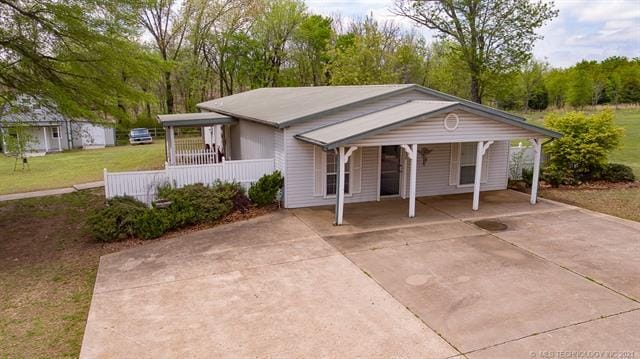
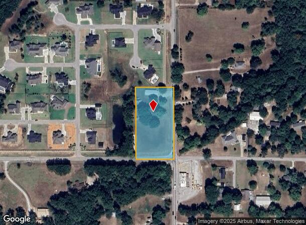
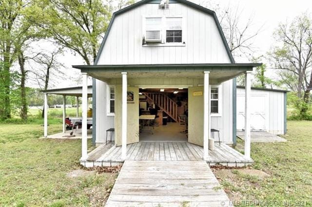
This Property Is For Sale
NEARBY LISTINGS FOR SALE OR LEASE
-
-
View all Broken Arrow listings for sale on LoopNet.com
Property Detail
13008 S 193Rd East Ave
97401-74-01-67110
Unplatted
Medicalbuilding
BEG SECR SE SE TH W240 N454 E240 S454 POB SEC 1 17 14
X
Tulsa
40143C0457M
Oklahoma
2025
2.50 AC
2025
Southeast
007536
Tulsa
3,929 SF
Tulsa, OK
DEMOGRAPHICS near 13008 S 193Rd East Ave
1 Mile
3 Mile
5 Mile
2024 Total Population
1,296
18,204
57,796
2029 Population
1,408
19,258
61,695
Pop Growth 2024-2029
+ 8.64%
+ 5.79%
+ 6.75%
Average Age
43
40
39
2024 Total Households
480
6,901
21,603
HH Growth 2024-2029
+ 8.54%
+ 5.67%
+ 6.63%
Median Household Inc
$97,990
$85,921
$79,614
Avg Household Size
2.70
2.60
2.60
2024 Avg HH Vehicles
2.00
2.00
2.00
Median Home Value
$306,881
$236,071
$216,868
Median Year Built
1996
1986
1988
Nearby Places
Map Layers
Map Styles
 Street
 Aerial
- Restaurants
- Banks
- Shops
- Fitness
- Groceries
PUBLIC TRANSPORTATION
AIRPORT
Tulsa International
DRIVE
WALK
Distance
Tulsa International
32 min
24.2 mi
Freight Ports
DRIVE
WALK
Distance
29 min
21.9 mi
Nearby Properties
Address
Land Use
TOTAL SIZE
Lot Size
Zoning
Address
Land Use
TOTAL SIZE
Lot Size
Zoning
37.23 AC
A1
Address
Land Use
TOTAL SIZE
Lot Size
Zoning
35,954 SF
27.97 AC
CN
Address
Land Use
TOTAL SIZE
Lot Size
Zoning
67,490 SF
5.40 AC
RM
Address
Land Use
TOTAL SIZE
Lot Size
Zoning
245,436 SF
12.21 AC
RM
Address
Land Use
TOTAL SIZE
Lot Size
Zoning
3,300 SF
40 AC
A1
Address
Land Use
TOTAL SIZE
Lot Size
Zoning
11,800 SF
2.45 AC
A1
Address
Land Use
TOTAL SIZE
Lot Size
Zoning
222,536 SF
11.31 AC
CN
Address
Land Use
TOTAL SIZE
Lot Size
Zoning
27,531 SF
4.46 AC
R2
Address
Land Use
TOTAL SIZE
Lot Size
Zoning
279,632 SF
14.54 AC
RM
Address
Land Use
TOTAL SIZE
Lot Size
Zoning
9,689 SF
101.01 AC
R2
Address
Land Use
TOTAL SIZE
Lot Size
Zoning
210,976 SF
22.52 AC
CG
Address
Land Use
TOTAL SIZE
Lot Size
Zoning
25,615 SF
4.62 AC
A1
Address
Land Use
TOTAL SIZE
Lot Size
Zoning
103,411 SF
24.39 AC
CN
Address
Land Use
TOTAL SIZE
Lot Size
Zoning
18,488 SF
4.43 AC
A1
Address
Land Use
TOTAL SIZE
Lot Size
Zoning
7,961 SF
9.10 AC
Address
Land Use
TOTAL SIZE
Lot Size
Zoning
112,420 SF
4.07 AC
IL
Address
Land Use
TOTAL SIZE
Lot Size
Zoning
60,575 SF
2.77 AC
CH
Address
Land Use
TOTAL SIZE
Lot Size
Zoning
1,560 SF
290 AC
Address
Land Use
TOTAL SIZE
Lot Size
Zoning
11,919 SF
16.77 AC
R2
Address
Land Use
TOTAL SIZE
Lot Size
Zoning
2,380 SF
1.06 AC
A1
Address
Land Use
TOTAL SIZE
Lot Size
Zoning
45,838 SF
8.83 AC
CG
Address
Land Use
TOTAL SIZE
Lot Size
Zoning
6,400 SF
14.96 AC
Address
Land Use
TOTAL SIZE
Lot Size
Zoning
6,414 SF
11.91 AC
R2
Address
Land Use
TOTAL SIZE
Lot Size
Zoning
127,319 SF
10.57 AC
IL
Address
Land Use
TOTAL SIZE
Lot Size
Zoning
75,303 SF
4.93 AC
RM
Address
Land Use
TOTAL SIZE
Lot Size
Zoning
4,732 SF
4.47 AC
A1
Address
Land Use
TOTAL SIZE
Lot Size
Zoning
62,251 SF
147.82 AC
R2
Address
Land Use
TOTAL SIZE
Lot Size
Zoning
74,115 SF
9.63 AC
RM
Address
Land Use
TOTAL SIZE
Lot Size
Zoning
12,280 SF
3.07 AC
R1
Address
Land Use
TOTAL SIZE
Lot Size
Zoning
3,251 SF
15.68 AC
The World's #1 Commercial Real Estate Marketplace
Connect with us
© 2026 CoStar Group
The information above has been obtained from sources believed reliable. While we do not doubt its accuracy we have not verified it and make no guarantee, warranty or representation about it. It is your responsibility to independently confirm its accuracy and completeness. Any projections, opinions, assumptions, or estimates used are for example only and do not represent the current or future performance of the property. The value of this transaction to you depends on tax and other factors which should be evaluated by your tax, financial, and legal advisors. You and your advisors should conduct a careful, independent investigation of the property to determine to your satisfaction the suitability of the property for your needs.