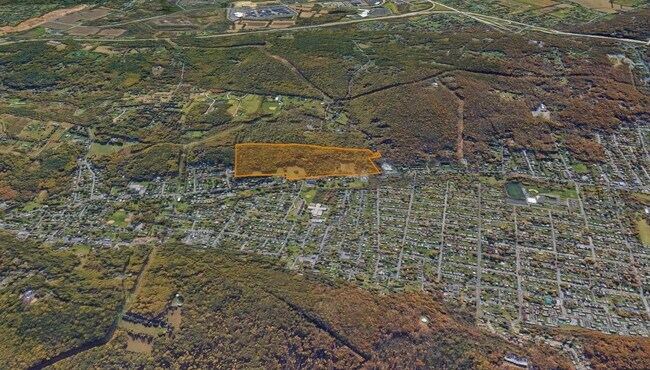
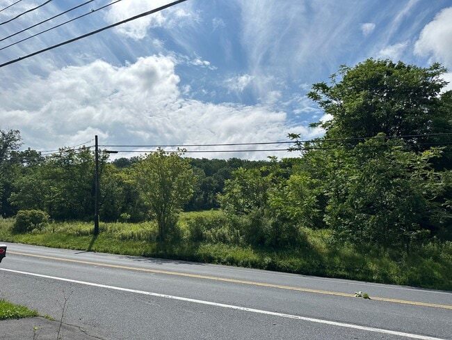
Property Record
1301 Black River Rd, Bethlehem, PA 18015
NEARBY LISTINGS FOR SALE OR LEASE
Property Detail
1301 Black River Rd
641643418652-1
LOTS: 007
Apartment
Lehigh
X
Pennsylvania
42077C0260F
7
2025
93.21 AC
2025
Lehigh Valley
001402
Philadelphia
2,646 SF
Allentown-Bethlehem-Easton, PA-NJ
DEMOGRAPHICS near 1301 Black River Rd
1 Mile
3 Mile
5 Mile
2024 Total Population
4,765
90,790
251,444
2029 Population
4,795
91,704
253,364
Pop Growth 2024-2029
+ 0.63%
+ 1.01%
+ 0.76%
Average Age
42
37
38
2024 Total Households
1,880
32,951
94,597
HH Growth 2024-2029
+ 0.64%
+ 1.24%
+ 0.85%
Median Household Inc
$67,857
$51,477
$56,342
Avg Household Size
2.50
2.60
2.50
2024 Avg HH Vehicles
2.00
2.00
2.00
Median Home Value
$212,225
$175,798
$197,660
Median Year Built
1957
1956
1956
Nearby Places
Map Layers
Map Styles
 Street
 Aerial
- Restaurants
- Banks
- Shops
- Fitness
- Groceries
PUBLIC TRANSPORTATION
AIRPORT
Lehigh Valley International
DRIVE
WALK
Distance
Lehigh Valley International
18 min
9.4 mi
Freight Ports
Port of Philadelphia
DRIVE
WALK
Distance
Port of Philadelphia
83 min
50.8 mi
SALE & LEASE HISTORY
LISTING DATE
SALE/LEASE

Jul 31, 2023
For Sale
Nearby Properties
Address
Land Use
TOTAL SIZE
Lot Size
Zoning
Address
Land Use
TOTAL SIZE
Lot Size
Zoning
541,843 SF
35.82 AC
INST
Address
Land Use
TOTAL SIZE
Lot Size
Zoning
187,337 SF
2.11 AC
I-G
Address
Land Use
TOTAL SIZE
Lot Size
Zoning
53,602 SF
55.38 AC
E
Address
Land Use
TOTAL SIZE
Lot Size
Zoning
229,379 SF
1.16 AC
I-G
Address
Land Use
TOTAL SIZE
Lot Size
Zoning
125,483 SF
45.29 AC
E
Address
Land Use
TOTAL SIZE
Lot Size
Zoning
165,557 SF
0.48 AC
B-2
Address
Land Use
TOTAL SIZE
Lot Size
Zoning
139,462 SF
1.30 AC
B-2
Address
Land Use
TOTAL SIZE
Lot Size
Zoning
101,901 SF
29.01 AC
E
Address
Land Use
TOTAL SIZE
Lot Size
Zoning
85,440 SF
2.10 AC
I-G
Address
Land Use
TOTAL SIZE
Lot Size
Zoning
565,540 SF
65.99 AC
I
Address
Land Use
TOTAL SIZE
Lot Size
Zoning
164,178 SF
14.88 AC
E
Address
Land Use
TOTAL SIZE
Lot Size
Zoning
335,939 SF
54 AC
E
Address
Land Use
TOTAL SIZE
Lot Size
Zoning
139,812 SF
0.14 AC
B-2
Address
Land Use
TOTAL SIZE
Lot Size
Zoning
42,250 SF
3.33 AC
I-G
Address
Land Use
TOTAL SIZE
Lot Size
Zoning
1,977 SF
31.73 AC
R-2
Address
Land Use
TOTAL SIZE
Lot Size
Zoning
71,838 SF
0.48 AC
I-G
Address
Land Use
TOTAL SIZE
Lot Size
Zoning
19,581 SF
15.99 AC
R-MP
Address
Land Use
TOTAL SIZE
Lot Size
Zoning
48.49 AC
P
Address
Land Use
TOTAL SIZE
Lot Size
Zoning
139,782 SF
27.47 AC
R4
Address
Land Use
TOTAL SIZE
Lot Size
Zoning
7,200 SF
22.31 AC
I-3
Address
Land Use
TOTAL SIZE
Lot Size
Zoning
38,650 SF
11.05 AC
R-H
Address
Land Use
TOTAL SIZE
Lot Size
Zoning
1,154,183 SF
83.21 AC
I-3
Address
Land Use
TOTAL SIZE
Lot Size
Zoning
57,764 SF
0.63 AC
I-G
Address
Land Use
TOTAL SIZE
Lot Size
Zoning
178,962 SF
1.58 AC
B-2
Address
Land Use
TOTAL SIZE
Lot Size
Zoning
87,517 SF
7.09 AC
E
Address
Land Use
TOTAL SIZE
Lot Size
Zoning
58,184 SF
27.14 AC
R-2
Address
Land Use
TOTAL SIZE
Lot Size
Zoning
63,400 SF
2.84 AC
I-G
Address
Land Use
TOTAL SIZE
Lot Size
Zoning
140,780 SF
21.91 AC
I-G
Address
Land Use
TOTAL SIZE
Lot Size
Zoning
344,603 SF
1.40 AC
B-2
Address
Land Use
TOTAL SIZE
Lot Size
Zoning
106,829 SF
14.15 AC
R4
The World's #1 Commercial Real Estate Marketplace
Connect with us
© 2025 CoStar Group
The information above has been obtained from sources believed reliable. While we do not doubt its accuracy we have not verified it and make no guarantee, warranty or representation about it. It is your responsibility to independently confirm its accuracy and completeness. Any projections, opinions, assumptions, or estimates used are for example only and do not represent the current or future performance of the property. The value of this transaction to you depends on tax and other factors which should be evaluated by your tax, financial, and legal advisors. You and your advisors should conduct a careful, independent investigation of the property to determine to your satisfaction the suitability of the property for your needs.