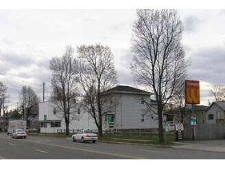
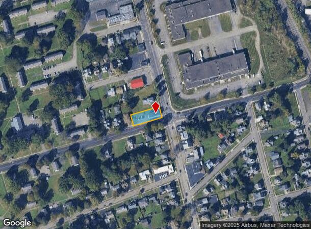
Property Record
1301 College Ave, Elmira, NY 14901
NEARBY LISTINGS FOR SALE OR LEASE
-
-
View all Elmira listings for sale on LoopNet.com
Property Detail
1301 College Ave
Elmira, NY
TEMP ASST.
070400-079-018-0002-032-000-0000
Chemung
Commercialofficeresidentialmixeduse
New York
2025
32.000
2024
0.24 AC
000200
Ithaca/Elmira
2,892 SF
Other Market Areas
DEMOGRAPHICS near 1301 College Ave
1 Mile
3 Mile
5 Mile
2024 Total Population
8,846
39,740
55,953
2029 Population
8,668
38,992
54,642
Pop Growth 2024-2029
(2.01%)
(1.88%)
(2.34%)
Average Age
40
41
42
2024 Total Households
3,329
16,944
23,994
HH Growth 2024-2029
(2.46%)
(2.02%)
(2.49%)
Median Household Inc
$46,043
$50,715
$55,664
Avg Household Size
2.30
2.20
2.20
2024 Avg HH Vehicles
1.00
1.00
2.00
Median Home Value
$70,229
$92,859
$109,462
Median Year Built
1947
1948
1950
Nearby Places
- Restaurants
- Banks
- Shops
- Fitness
- Groceries
PUBLIC TRANSPORTATION
AIRPORT
Elmira/Corning Regional
DRIVE
WALK
Distance
Elmira/Corning Regional
14 min
9.2 mi
Freight Ports
Albany, NY Port
DRIVE
WALK
Distance
Albany, NY Port
234 min
196.1 mi
Nearby Properties
Address
Land Use
TOTAL SIZE
Lot Size
Zoning
Address
Land Use
TOTAL SIZE
Lot Size
Zoning
59 AC
UNZONED
Address
Land Use
TOTAL SIZE
Lot Size
Zoning
118,475 SF
0.71 AC
LAC2
Address
Land Use
TOTAL SIZE
Lot Size
Zoning
308,479 SF
28.20 AC
HA
Address
Land Use
TOTAL SIZE
Lot Size
Zoning
290,934 SF
13.50 AC
HED
Address
Land Use
TOTAL SIZE
Lot Size
Zoning
271,462 SF
7.50 AC
HS
Address
Land Use
TOTAL SIZE
Lot Size
Zoning
160.74 AC
AR
Address
Land Use
TOTAL SIZE
Lot Size
Zoning
60,899 SF
207.30 AC
TH02
Address
Land Use
TOTAL SIZE
Lot Size
Zoning
31,140 SF
13.50 AC
HA
Address
Land Use
TOTAL SIZE
Lot Size
Zoning
Address
Land Use
TOTAL SIZE
Lot Size
Zoning
Address
Land Use
TOTAL SIZE
Lot Size
Zoning
25,388 SF
58.90 AC
RAA
Address
Land Use
TOTAL SIZE
Lot Size
Zoning
18.61 AC
IB
Address
Land Use
TOTAL SIZE
Lot Size
Zoning
52,628 SF
2.40 AC
HED
Address
Land Use
TOTAL SIZE
Lot Size
Zoning
103,764 SF
31.98 AC
R2
Address
Land Use
TOTAL SIZE
Lot Size
Zoning
Address
Land Use
TOTAL SIZE
Lot Size
Zoning
61,157 SF
1 AC
CBD
Address
Land Use
TOTAL SIZE
Lot Size
Zoning
99,188 SF
16.80 AC
R2
Address
Land Use
TOTAL SIZE
Lot Size
Zoning
136,977 SF
2.55 AC
HED
Address
Land Use
TOTAL SIZE
Lot Size
Zoning
194,626 SF
10.20 AC
RAA
Address
Land Use
TOTAL SIZE
Lot Size
Zoning
5,562 SF
22.64 AC
RD
Address
Land Use
TOTAL SIZE
Lot Size
Zoning
14.10 AC
M
Address
Land Use
TOTAL SIZE
Lot Size
Zoning
157,418 SF
0.72 AC
CBD
Address
Land Use
TOTAL SIZE
Lot Size
Zoning
130,248 SF
7.10 AC
HA
Address
Land Use
TOTAL SIZE
Lot Size
Zoning
82,385 SF
18.38 AC
BE
Address
Land Use
TOTAL SIZE
Lot Size
Zoning
13,468 SF
4.07 AC
TH04
Address
Land Use
TOTAL SIZE
Lot Size
Zoning
159,458 SF
3.15 AC
UMU
Address
Land Use
TOTAL SIZE
Lot Size
Zoning
77,451 SF
4.70 AC
AA
Address
Land Use
TOTAL SIZE
Lot Size
Zoning
52,122 SF
1.45 AC
HA
Address
Land Use
TOTAL SIZE
Lot Size
Zoning
Address
Land Use
TOTAL SIZE
Lot Size
Zoning
94,011 SF
14.80 AC
TH08
The World's #1 Commercial Real Estate Marketplace
Connect with us
© 2025 CoStar Group
The information above has been obtained from sources believed reliable. While we do not doubt its accuracy we have not verified it and make no guarantee, warranty or representation about it. It is your responsibility to independently confirm its accuracy and completeness. Any projections, opinions, assumptions, or estimates used are for example only and do not represent the current or future performance of the property. The value of this transaction to you depends on tax and other factors which should be evaluated by your tax, financial, and legal advisors. You and your advisors should conduct a careful, independent investigation of the property to determine to your satisfaction the suitability of the property for your needs.