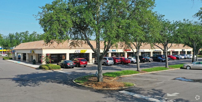
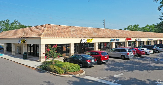
Property Record
1301 E Vine St, Kissimmee, FL 34744

NEARBY LISTINGS FOR SALE OR LEASE
Property Detail
1301 E Vine St
Orlando-Kissimmee-Sanford, FL
Acreage & Unrec
14-25-29-00U0-0302-0000
COMM NW COR OF SW 1/4 OF SW 1/4 S 930 FT, E 53 FT TO POB, S 339 FT MOL, E 858.38 FT, N 200 FT, E 200 FT, N 640.69 FT, W 311.35 FT, S 300 FT, W 547 FT, S 200 FT, W 200 FT TO POB
Regionalshoppingcenterormallwithanchorstore
Osceola
X
Florida
12097C0067G
302
2024
13.34 AC
2025
Kissimmee
042300
Orlando
118,219 SF
DEMOGRAPHICS near 1301 E Vine St
1 Mile
3 Mile
5 Mile
2024 Total Population
8,002
89,378
210,095
2029 Population
9,539
106,540
244,271
Pop Growth 2024-2029
+ 19.21%
+ 19.20%
+ 16.27%
Average Age
39
38
38
2024 Total Households
2,649
30,352
69,771
HH Growth 2024-2029
+ 19.03%
+ 19.05%
+ 16.24%
Median Household Inc
$46,651
$45,811
$53,376
Avg Household Size
2.90
2.80
2.90
2024 Avg HH Vehicles
2.00
2.00
2.00
Median Home Value
$189,071
$238,956
$270,317
Median Year Built
1986
1991
1997
Nearby Places
Map Layers
Map Styles
 Street
 Aerial
- Restaurants
- Banks
- Shops
- Fitness
- Groceries
PUBLIC TRANSPORTATION
COMMUTER RAIL
Kissimmee Amtrak Station (Silver Meteor - Amtrak, Silver Star - Amtrak, SunRail - Amtrak)
DRIVE
WALK
Distance
Kissimmee Amtrak Station (Silver Meteor - Amtrak, Silver Star - Amtrak, SunRail - Amtrak)
4 min
1.8 mi
Tupperware (SunRail - Florida Department of Transportation)
DRIVE
WALK
Distance
Tupperware (SunRail - Florida Department of Transportation)
7 min
2.8 mi
AIRPORT
Orlando International
DRIVE
WALK
Distance
Orlando International
24 min
15.5 mi
Freight Ports
Port Canaveral
DRIVE
WALK
Distance
Port Canaveral
71 min
57.3 mi
SALE & LEASE HISTORY
LISTING DATE
SALE/LEASE

Sep 25, 2016
For Lease
Sep 24, 2016
For Lease
Apr 15, 2019
For Lease
Nearby Properties
Address
Land Use
TOTAL SIZE
Lot Size
Zoning
Address
Land Use
TOTAL SIZE
Lot Size
Zoning
579,863 SF
25.98 AC
KHF
Address
Land Use
TOTAL SIZE
Lot Size
Zoning
425,391 SF
63.04 AC
Address
Land Use
TOTAL SIZE
Lot Size
Zoning
426,324 SF
25.52 AC
KRC2
Address
Land Use
TOTAL SIZE
Lot Size
Zoning
475,697 SF
21.04 AC
OPD
Address
Land Use
TOTAL SIZE
Lot Size
Zoning
402,010 SF
22.33 AC
OCR
Address
Land Use
TOTAL SIZE
Lot Size
Zoning
360,431 SF
34.06 AC
KRPU
Address
Land Use
TOTAL SIZE
Lot Size
Zoning
449,570 SF
15.34 AC
OPD
Address
Land Use
TOTAL SIZE
Lot Size
Zoning
305,166 SF
30.36 AC
KMPU
Address
Land Use
TOTAL SIZE
Lot Size
Zoning
334,569 SF
11.82 AC
Address
Land Use
TOTAL SIZE
Lot Size
Zoning
416,762 SF
99.87 AC
KCF
Address
Land Use
TOTAL SIZE
Lot Size
Zoning
393,815 SF
17.89 AC
OPD
Address
Land Use
TOTAL SIZE
Lot Size
Zoning
379,943 SF
14.07 AC
OCT
Address
Land Use
TOTAL SIZE
Lot Size
Zoning
382,006 SF
12.38 AC
OPD
Address
Land Use
TOTAL SIZE
Lot Size
Zoning
281,141 SF
7.36 AC
KOS
Address
Land Use
TOTAL SIZE
Lot Size
Zoning
286,320 SF
27.06 AC
Address
Land Use
TOTAL SIZE
Lot Size
Zoning
142,570 SF
20.16 AC
OPD
Address
Land Use
TOTAL SIZE
Lot Size
Zoning
220,535 SF
10.23 AC
KRA2
Address
Land Use
TOTAL SIZE
Lot Size
Zoning
296,645 SF
14.65 AC
Address
Land Use
TOTAL SIZE
Lot Size
Zoning
366,024 SF
19.19 AC
KRC1
Address
Land Use
TOTAL SIZE
Lot Size
Zoning
351,537 SF
44.58 AC
OPD
Address
Land Use
TOTAL SIZE
Lot Size
Zoning
172,394 SF
17.95 AC
KRC1
Address
Land Use
TOTAL SIZE
Lot Size
Zoning
232,770 SF
11.91 AC
KRC2
Address
Land Use
TOTAL SIZE
Lot Size
Zoning
230,530 SF
17.74 AC
KRPU
Address
Land Use
TOTAL SIZE
Lot Size
Zoning
219,362 SF
15.64 AC
KRC1
Address
Land Use
TOTAL SIZE
Lot Size
Zoning
170,602 SF
17.07 AC
KRC1
Address
Land Use
TOTAL SIZE
Lot Size
Zoning
374,081 SF
36.66 AC
KRC1
Address
Land Use
TOTAL SIZE
Lot Size
Zoning
367,143 SF
22.65 AC
RS-3
Address
Land Use
TOTAL SIZE
Lot Size
Zoning
244,749 SF
20.15 AC
Address
Land Use
TOTAL SIZE
Lot Size
Zoning
177,376 SF
8.62 AC
KRC1
Address
Land Use
TOTAL SIZE
Lot Size
Zoning
180,209 SF
16 AC
KRC1
The World's #1 Commercial Real Estate Marketplace
Connect with us
© 2025 CoStar Group
The information above has been obtained from sources believed reliable. While we do not doubt its accuracy we have not verified it and make no guarantee, warranty or representation about it. It is your responsibility to independently confirm its accuracy and completeness. Any projections, opinions, assumptions, or estimates used are for example only and do not represent the current or future performance of the property. The value of this transaction to you depends on tax and other factors which should be evaluated by your tax, financial, and legal advisors. You and your advisors should conduct a careful, independent investigation of the property to determine to your satisfaction the suitability of the property for your needs.