Property Record
1301 Long Plains Rd, Buxton, ME 04093
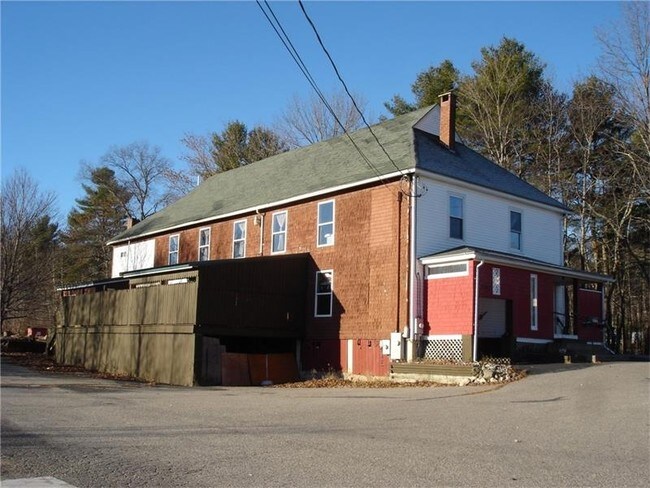

Property Detail
1301 Long Plains Rd
Religious
YORK
BUXTON
Maine
B and X Area of moderate flood hazard, usually the area between the limits of the 100-year and 500-year floods.
2 AC
2024
York County
2025
Portland/South Portland
020001
Portland-South Portland, ME
4,818 SF
BUXT-000006-000000-000046
NEARBY LISTINGS FOR SALE OR LEASE
DEMOGRAPHICS near 1301 Long Plains Rd
1 mile
3 mile
5 mile
2025 Total Population
350
5,009
25,094
2030 Population
346
5,032
26,120
Pop Growth 2025-2030
(1.14%)
+ 0.46%
+ 4.09%
Average Age
44
43
40
2025 Total Households
139
1,927
9,116
HH Growth 2025-2030
(1.44%)
+ 0.31%
+ 4.12%
Median Household Inc
$98,105
$111,351
$111,634
Avg Household Size
2.50
2.50
2.60
2025 Avg HH Vehicles
2.00
2.00
2.00
Median Home Value
$418,000
$434,590
$466,758
Median Year Built
1986
1984
1989
Nearby Places
Map Layers
Map Styles
 Street
 Aerial
Layers
 Traffic
 Biking
Places
Listings with unknown addresses are not visible on the map
- Restaurants
- Banks
- Shops
- Fitness
- Groceries
PUBLIC TRANSPORTATION
AIRPORT
Portland International Jetport
Drive
Walk
Distance
Portland International Jetport
23 min
11.2 mi
Freight Ports
Portland, ME
Drive
Walk
Distance
Portland, ME
27 min
14.8 mi
SALE & LEASE HISTORY
LISTING DATE
SALE/LEASE

May 19, 2023
For Sale
Nearby Properties
Address
Land Use
TOTAL SIZE
Lot Size
Zoning
Address
Land Use
TOTAL SIZE
Lot Size
Zoning
35,441 SF
12 AC
BUXTON
Address
Land Use
TOTAL SIZE
Lot Size
Zoning
9,152 SF
39.96 AC
BUXTON
Address
Land Use
TOTAL SIZE
Lot Size
Zoning
10,704 SF
196 AC
BUXTON
Address
Land Use
TOTAL SIZE
Lot Size
Zoning
15,930 SF
8.26 AC
BUXTON
Address
Land Use
TOTAL SIZE
Lot Size
Zoning
4,216 SF
3.13 AC
BUXTON
Address
Land Use
TOTAL SIZE
Lot Size
Zoning
8,800 SF
2.97 AC
BUXTON
Address
Land Use
TOTAL SIZE
Lot Size
Zoning
896 SF
10.77 AC
BUXTON
Address
Land Use
TOTAL SIZE
Lot Size
Zoning
1,200 SF
2.20 AC
BUXTON
Address
Land Use
TOTAL SIZE
Lot Size
Zoning
30.40 AC
16
Address
Land Use
TOTAL SIZE
Lot Size
Zoning
2,400 SF
2.60 AC
BUXTON
Address
Land Use
TOTAL SIZE
Lot Size
Zoning
5,250 SF
1.84 AC
BUXTON
Address
Land Use
TOTAL SIZE
Lot Size
Zoning
3,264 SF
32 AC
BUXTON
Address
Land Use
TOTAL SIZE
Lot Size
Zoning
10,000 SF
1.60 AC
BUXTON
Address
Land Use
TOTAL SIZE
Lot Size
Zoning
64.99 AC
RR3
Address
Land Use
TOTAL SIZE
Lot Size
Zoning
2,470 SF
10.69 AC
BUXTON
Address
Land Use
TOTAL SIZE
Lot Size
Zoning
3,780 SF
0.89 AC
BUXTON
Address
Land Use
TOTAL SIZE
Lot Size
Zoning
3,200 SF
5.30 AC
BUXTON
Address
Land Use
TOTAL SIZE
Lot Size
Zoning
1,680 SF
3.25 AC
BUXTON
Address
Land Use
TOTAL SIZE
Lot Size
Zoning
12,350 SF
2.44 AC
BUXTON
Address
Land Use
TOTAL SIZE
Lot Size
Zoning
1,870 SF
6.16 AC
BUXTON
Address
Land Use
TOTAL SIZE
Lot Size
Zoning
600 SF
4.62 AC
BUXTON
Address
Land Use
TOTAL SIZE
Lot Size
Zoning
1,224 SF
0.94 AC
BUXTON
Address
Land Use
TOTAL SIZE
Lot Size
Zoning
3,437 SF
0.75 AC
BUXTON
Address
Land Use
TOTAL SIZE
Lot Size
Zoning
1,080 SF
3.10 AC
BUXTON
Address
Land Use
TOTAL SIZE
Lot Size
Zoning
1,600 SF
5 AC
BUXTON
Address
Land Use
TOTAL SIZE
Lot Size
Zoning
1,080 SF
46.40 AC
BUXTON
Address
Land Use
TOTAL SIZE
Lot Size
Zoning
560 SF
2.35 AC
BUXTON
Address
Land Use
TOTAL SIZE
Lot Size
Zoning
2,264 SF
32.10 AC
16
Address
Land Use
TOTAL SIZE
Lot Size
Zoning
27.54 AC
16
Address
Land Use
TOTAL SIZE
Lot Size
Zoning
1,872 SF
8.60 AC
BUXTON
The World's #1 Commercial Real Estate Marketplace
Connect with us
© 2026 CoStar Group
The information above has been obtained from sources believed reliable. While we do not doubt its accuracy we have not verified it and make no guarantee, warranty or representation about it. It is your responsibility to independently confirm its accuracy and completeness. Any projections, opinions, assumptions, or estimates used are for example only and do not represent the current or future performance of the property. The value of this transaction to you depends on tax and other factors which should be evaluated by your tax, financial, and legal advisors. You and your advisors should conduct a careful, independent investigation of the property to determine to your satisfaction the suitability of the property for your needs.