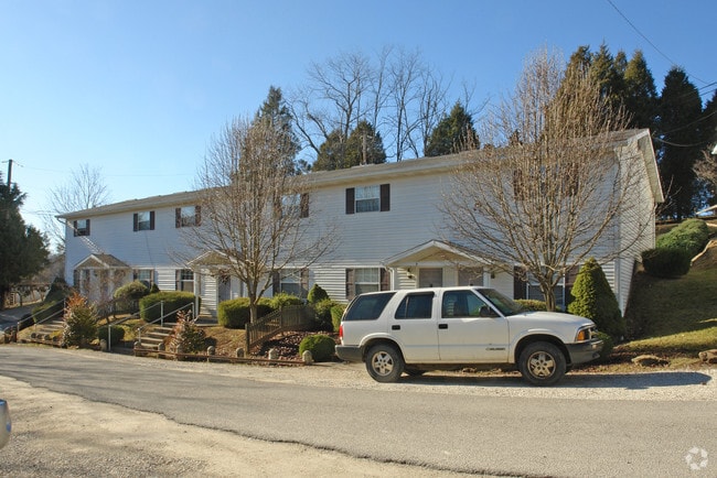
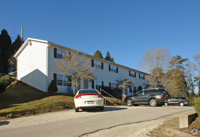
Property Record
1301 Martha Rd, Barboursville, WV 25504

NEARBY LISTINGS FOR SALE OR LEASE
-
-
View all Barboursville listings for sale on LoopNet.com
Property Detail
1301 Martha Rd
08-4-00430000
74.90 AC GUY RIV 1840 MARTHA RD B'VILLE LAKEVIEW DR -APTS
Commercialofficeresidentialmixeduse
Cabell
X
West Virginia
54011C0143D
74.90 AC
2025
Outlying Cabell County
2025
Huntington/Ashland
010402
Huntington-Ashland, WV-KY-OH
DEMOGRAPHICS near 1301 Martha Rd
1 Mile
3 Mile
5 Mile
2024 Total Population
924
14,500
27,280
2029 Population
898
14,114
26,540
Pop Growth 2024-2029
(2.81%)
(2.66%)
(2.71%)
Average Age
42
42
41
2024 Total Households
364
5,909
11,348
HH Growth 2024-2029
(3.02%)
(2.91%)
(2.93%)
Median Household Inc
$61,667
$58,617
$56,890
Avg Household Size
2.50
2.20
2.30
2024 Avg HH Vehicles
2.00
2.00
2.00
Median Home Value
$208,696
$173,804
$172,289
Median Year Built
1976
1975
1976
Nearby Places
Map Layers
Map Styles
 Street
 Aerial
- Restaurants
- Banks
- Shops
- Fitness
- Groceries
PUBLIC TRANSPORTATION
AIRPORT
Tri-State/Milton J Ferguson Field
DRIVE
WALK
Distance
Tri-State/Milton J Ferguson Field
35 min
23.9 mi
Freight Ports
Port of Toledo
DRIVE
WALK
Distance
Port of Toledo
363 min
283.5 mi
Nearby Properties
Address
Land Use
TOTAL SIZE
Lot Size
Zoning
Address
Land Use
TOTAL SIZE
Lot Size
Zoning
82.79 AC
Address
Land Use
TOTAL SIZE
Lot Size
Zoning
17.51 AC
Address
Land Use
TOTAL SIZE
Lot Size
Zoning
27.42 AC
Address
Land Use
TOTAL SIZE
Lot Size
Zoning
Address
Land Use
TOTAL SIZE
Lot Size
Zoning
1.97 AC
Address
Land Use
TOTAL SIZE
Lot Size
Zoning
15.48 AC
Address
Land Use
TOTAL SIZE
Lot Size
Zoning
Address
Land Use
TOTAL SIZE
Lot Size
Zoning
Address
Land Use
TOTAL SIZE
Lot Size
Zoning
Address
Land Use
TOTAL SIZE
Lot Size
Zoning
Address
Land Use
TOTAL SIZE
Lot Size
Zoning
416.94 AC
Address
Land Use
TOTAL SIZE
Lot Size
Zoning
Address
Land Use
TOTAL SIZE
Lot Size
Zoning
9.32 AC
Address
Land Use
TOTAL SIZE
Lot Size
Zoning
15.87 AC
Address
Land Use
TOTAL SIZE
Lot Size
Zoning
Address
Land Use
TOTAL SIZE
Lot Size
Zoning
5.32 AC
Address
Land Use
TOTAL SIZE
Lot Size
Zoning
Address
Land Use
TOTAL SIZE
Lot Size
Zoning
Address
Land Use
TOTAL SIZE
Lot Size
Zoning
17.38 AC
Address
Land Use
TOTAL SIZE
Lot Size
Zoning
Address
Land Use
TOTAL SIZE
Lot Size
Zoning
Address
Land Use
TOTAL SIZE
Lot Size
Zoning
Address
Land Use
TOTAL SIZE
Lot Size
Zoning
5.17 AC
Address
Land Use
TOTAL SIZE
Lot Size
Zoning
9.39 AC
Address
Land Use
TOTAL SIZE
Lot Size
Zoning
11.58 AC
Address
Land Use
TOTAL SIZE
Lot Size
Zoning
2.78 AC
Address
Land Use
TOTAL SIZE
Lot Size
Zoning
Address
Land Use
TOTAL SIZE
Lot Size
Zoning
Address
Land Use
TOTAL SIZE
Lot Size
Zoning
Address
Land Use
TOTAL SIZE
Lot Size
Zoning
The World's #1 Commercial Real Estate Marketplace
Connect with us
© 2026 CoStar Group
The information above has been obtained from sources believed reliable. While we do not doubt its accuracy we have not verified it and make no guarantee, warranty or representation about it. It is your responsibility to independently confirm its accuracy and completeness. Any projections, opinions, assumptions, or estimates used are for example only and do not represent the current or future performance of the property. The value of this transaction to you depends on tax and other factors which should be evaluated by your tax, financial, and legal advisors. You and your advisors should conduct a careful, independent investigation of the property to determine to your satisfaction the suitability of the property for your needs.