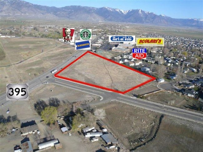
Property Record
1301 N Highway 395 N, Gardnerville, NV 89410


NEARBY LISTINGS FOR SALE OR LEASE
Property Detail
1301 N Highway 395 N
Gardnerville Ranchos, NV
LOT 1
1220-04-602-012
Douglas
Commercialnec
Nevada
AO
1
32005C0261H
4.55 AC
2024
Douglas County
2025
Reno/Sparks
002300
DEMOGRAPHICS near 1301 N Highway 395 N
1 Mile
3 Mile
5 Mile
2024 Total Population
4,555
19,161
25,990
2029 Population
4,597
19,477
26,416
Pop Growth 2024-2029
+ 0.92%
+ 1.65%
+ 1.64%
Average Age
45
47
47
2024 Total Households
2,023
8,327
11,159
HH Growth 2024-2029
+ 0.99%
+ 1.69%
+ 1.68%
Median Household Inc
$67,941
$76,406
$78,714
Avg Household Size
2.20
2.30
2.30
2024 Avg HH Vehicles
2.00
2.00
2.00
Median Home Value
$386,617
$445,393
$453,074
Median Year Built
2001
1993
1993
Nearby Places
Map Layers
Map Styles
 Street
 Aerial
- Restaurants
- Banks
- Shops
- Fitness
- Groceries
SALE & LEASE HISTORY
LISTING DATE
SALE/LEASE

Sep 24, 2016
For Sale
Mar 27, 2018
For Sale
Apr 14, 2017
For Sale
Nearby Properties
Address
Land Use
TOTAL SIZE
Lot Size
Zoning
Address
Land Use
TOTAL SIZE
Lot Size
Zoning
266,955 SF
26.62 AC
Address
Land Use
TOTAL SIZE
Lot Size
Zoning
128,688 SF
10 AC
Address
Land Use
TOTAL SIZE
Lot Size
Zoning
67,309 SF
21.20 AC
Address
Land Use
TOTAL SIZE
Lot Size
Zoning
188,096 SF
20.87 AC
Address
Land Use
TOTAL SIZE
Lot Size
Zoning
153,623 SF
17.65 AC
Address
Land Use
TOTAL SIZE
Lot Size
Zoning
82,367 SF
27.90 AC
Address
Land Use
TOTAL SIZE
Lot Size
Zoning
119,616 SF
8.70 AC
Address
Land Use
TOTAL SIZE
Lot Size
Zoning
51,300 SF
10 AC
Address
Land Use
TOTAL SIZE
Lot Size
Zoning
83,040 SF
6.51 AC
Address
Land Use
TOTAL SIZE
Lot Size
Zoning
108,444 SF
25.72 AC
Address
Land Use
TOTAL SIZE
Lot Size
Zoning
16,288 SF
2.02 AC
Address
Land Use
TOTAL SIZE
Lot Size
Zoning
153,210 SF
13.21 AC
Address
Land Use
TOTAL SIZE
Lot Size
Zoning
68,860 SF
12 AC
Address
Land Use
TOTAL SIZE
Lot Size
Zoning
48,789 SF
2.34 AC
Address
Land Use
TOTAL SIZE
Lot Size
Zoning
29,349 SF
3.24 AC
Address
Land Use
TOTAL SIZE
Lot Size
Zoning
49,737 SF
5.91 AC
Address
Land Use
TOTAL SIZE
Lot Size
Zoning
54,000 SF
5.35 AC
Address
Land Use
TOTAL SIZE
Lot Size
Zoning
64,813 SF
9.37 AC
Address
Land Use
TOTAL SIZE
Lot Size
Zoning
5,194 SF
36.84 AC
Address
Land Use
TOTAL SIZE
Lot Size
Zoning
31,543 SF
6.20 AC
Address
Land Use
TOTAL SIZE
Lot Size
Zoning
35,365 SF
5.08 AC
Address
Land Use
TOTAL SIZE
Lot Size
Zoning
60,424 SF
8.08 AC
Address
Land Use
TOTAL SIZE
Lot Size
Zoning
52,392 SF
3.10 AC
Address
Land Use
TOTAL SIZE
Lot Size
Zoning
20,587 SF
5.08 AC
Address
Land Use
TOTAL SIZE
Lot Size
Zoning
42,150 SF
4.28 AC
Address
Land Use
TOTAL SIZE
Lot Size
Zoning
7,085 SF
35.96 AC
Address
Land Use
TOTAL SIZE
Lot Size
Zoning
15,018 SF
4.35 AC
Address
Land Use
TOTAL SIZE
Lot Size
Zoning
51.31 AC
The World's #1 Commercial Real Estate Marketplace
Connect with us
© 2025 CoStar Group
The information above has been obtained from sources believed reliable. While we do not doubt its accuracy we have not verified it and make no guarantee, warranty or representation about it. It is your responsibility to independently confirm its accuracy and completeness. Any projections, opinions, assumptions, or estimates used are for example only and do not represent the current or future performance of the property. The value of this transaction to you depends on tax and other factors which should be evaluated by your tax, financial, and legal advisors. You and your advisors should conduct a careful, independent investigation of the property to determine to your satisfaction the suitability of the property for your needs.