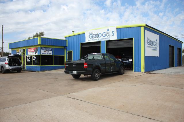
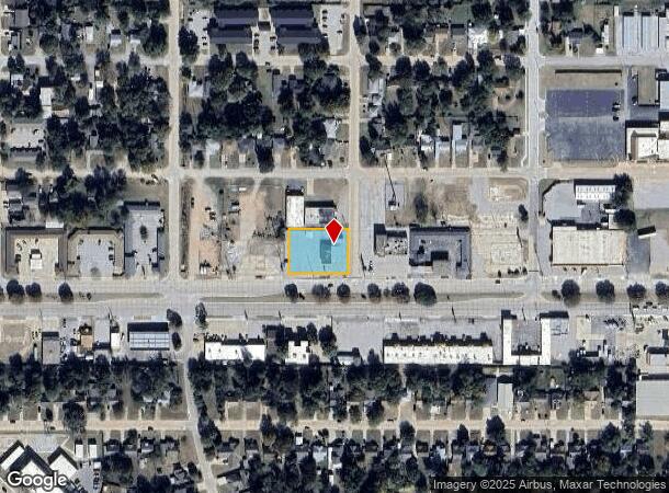
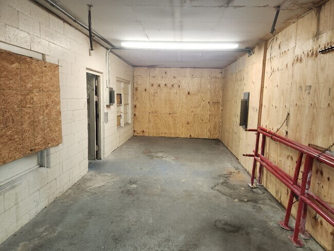
Property Record
1301 Nw Cache Rd, Lawton, OK 73507
Current Lease Availabilities
NEARBY LISTINGS FOR SALE OR LEASE
Property Detail
1301 Nw Cache Rd
Lawton, OK
Lawton Heights
160032570
LAWTON HEIGHTS BLK 118 LOTS 27-32 INCL
Autorepair
Comanche
X
Oklahoma
40031C0431E
27-32
2024
0.53 AC
2025
Oklahoma West Area
000800
Other Market Areas
3,584 SF
DEMOGRAPHICS near 1301 Nw Cache Rd
1 Mile
3 Mile
5 Mile
2024 Total Population
10,146
53,548
93,725
2029 Population
10,651
55,723
96,912
Pop Growth 2024-2029
+ 4.98%
+ 4.06%
+ 3.40%
Average Age
37
35
36
2024 Total Households
4,290
20,475
34,936
HH Growth 2024-2029
+ 5.01%
+ 4.40%
+ 3.66%
Median Household Inc
$39,378
$37,603
$45,545
Avg Household Size
2.30
2.30
2.40
2024 Avg HH Vehicles
1.00
1.00
2.00
Median Home Value
$85,769
$91,854
$136,369
Median Year Built
1955
1966
1974
Nearby Places
- Restaurants
- Banks
- Shops
- Fitness
- Groceries
PUBLIC TRANSPORTATION
AIRPORT
Lawton-Fort Sill Regional
DRIVE
WALK
Distance
Lawton-Fort Sill Regional
12 min
5.1 mi
Nearby Properties
Address
Land Use
TOTAL SIZE
Lot Size
Zoning
Address
Land Use
TOTAL SIZE
Lot Size
Zoning
74,800 SF
1.41 AC
Address
Land Use
TOTAL SIZE
Lot Size
Zoning
2,288 SF
2.94 AC
Address
Land Use
TOTAL SIZE
Lot Size
Zoning
32,000 SF
5.32 AC
Address
Land Use
TOTAL SIZE
Lot Size
Zoning
52,295 SF
2.50 AC
Address
Land Use
TOTAL SIZE
Lot Size
Zoning
22,987 SF
3.40 AC
Address
Land Use
TOTAL SIZE
Lot Size
Zoning
14,000 SF
17.19 AC
Address
Land Use
TOTAL SIZE
Lot Size
Zoning
114,352 SF
14.84 AC
Address
Land Use
TOTAL SIZE
Lot Size
Zoning
800 SF
15.64 AC
Address
Land Use
TOTAL SIZE
Lot Size
Zoning
195,881 SF
15.39 AC
Address
Land Use
TOTAL SIZE
Lot Size
Zoning
12,068 SF
5.31 AC
Address
Land Use
TOTAL SIZE
Lot Size
Zoning
16,996 SF
12.16 AC
Address
Land Use
TOTAL SIZE
Lot Size
Zoning
2,376 SF
8.64 AC
Address
Land Use
TOTAL SIZE
Lot Size
Zoning
123,414 SF
17.50 AC
Address
Land Use
TOTAL SIZE
Lot Size
Zoning
117,301 SF
13.83 AC
Address
Land Use
TOTAL SIZE
Lot Size
Zoning
63,224 SF
2.66 AC
Address
Land Use
TOTAL SIZE
Lot Size
Zoning
82,509 SF
6.29 AC
Address
Land Use
TOTAL SIZE
Lot Size
Zoning
2,688 SF
4.50 AC
Address
Land Use
TOTAL SIZE
Lot Size
Zoning
41,192 SF
6.60 AC
Address
Land Use
TOTAL SIZE
Lot Size
Zoning
57,096 SF
16.03 AC
Address
Land Use
TOTAL SIZE
Lot Size
Zoning
6,251 SF
3.70 AC
Address
Land Use
TOTAL SIZE
Lot Size
Zoning
7,960 SF
0.58 AC
Address
Land Use
TOTAL SIZE
Lot Size
Zoning
3,292 SF
1.13 AC
Address
Land Use
TOTAL SIZE
Lot Size
Zoning
14,620 SF
1.13 AC
Address
Land Use
TOTAL SIZE
Lot Size
Zoning
52,568 SF
1.50 AC
Address
Land Use
TOTAL SIZE
Lot Size
Zoning
18,312 SF
3.08 AC
Address
Land Use
TOTAL SIZE
Lot Size
Zoning
61,984 SF
1.58 AC
Address
Land Use
TOTAL SIZE
Lot Size
Zoning
23,800 SF
4.34 AC
Address
Land Use
TOTAL SIZE
Lot Size
Zoning
53,432 SF
1.88 AC
Address
Land Use
TOTAL SIZE
Lot Size
Zoning
95,268 SF
6.20 AC
Address
Land Use
TOTAL SIZE
Lot Size
Zoning
11,368 SF
7.42 AC
The World's #1 Commercial Real Estate Marketplace
Connect with us
© 2025 CoStar Group
The information above has been obtained from sources believed reliable. While we do not doubt its accuracy we have not verified it and make no guarantee, warranty or representation about it. It is your responsibility to independently confirm its accuracy and completeness. Any projections, opinions, assumptions, or estimates used are for example only and do not represent the current or future performance of the property. The value of this transaction to you depends on tax and other factors which should be evaluated by your tax, financial, and legal advisors. You and your advisors should conduct a careful, independent investigation of the property to determine to your satisfaction the suitability of the property for your needs.