Property Record
1301 Schiferl Rd, Bartlett, IL 60103
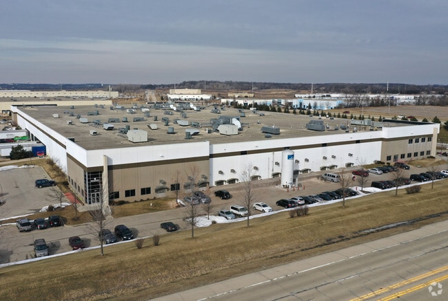

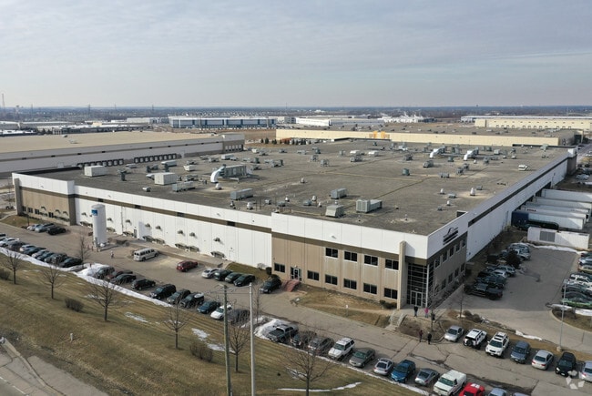

Property Detail
1301 Schiferl Rd
01-05-402-004
ASSMT PLAT NO 5 OF LT 9 BREWSTER CREEK BUSINESS PARK UNIT 1 ALL LOT 9E1
Industrialgeneral
DuPage
I
Illinois
B and X Area of moderate flood hazard, usually the area between the limits of the 100-year and 500-year floods.
9
2024
15.92 AC
2024
Northwest Cook
841308
Chicago
272,606 SF
Chicago-Naperville-Elgin, IL-IN
NEARBY LISTINGS FOR SALE OR LEASE
DEMOGRAPHICS near 1301 Schiferl Rd
1 mile
3 mile
5 mile
2025 Total Population
667
41,572
183,771
2030 Population
662
41,719
184,679
Pop Growth 2025-2030
(0.75%)
+ 0.35%
+ 0.49%
Average Age
45
42
40
2025 Total Households
240
14,385
60,858
HH Growth 2025-2030
(0.83%)
+ 0.20%
+ 0.38%
Median Household Inc
$113,888
$127,795
$104,700
Avg Household Size
2.80
2.80
2.90
2025 Avg HH Vehicles
3.00
2.00
2.00
Median Home Value
$522,727
$355,109
$304,118
Median Year Built
1991
1989
1983
Nearby Places
Map Layers
Map Styles
 Street
 Aerial
Transit
 Traffic
 Biking
Places
Listings with unknown addresses are not visible on the map
- Restaurants
- Banks
- Shops
- Fitness
- Groceries
PUBLIC TRANSPORTATION
COMMUTER RAIL
Bartlett Station (Milwaukee District West Line - Northeast Illinois Regional Commuter Railroad (Metra))
Drive
Walk
Distance
Bartlett Station (Milwaukee District West Line - Northeast Illinois Regional Commuter Railroad (Metra))
7 min
3.1 mi
Hanover Park Station (Milwaukee District West Line - Northeast Illinois Regional Commuter Railroad (Metra))
Drive
Walk
Distance
Hanover Park Station (Milwaukee District West Line - Northeast Illinois Regional Commuter Railroad (Metra))
11 min
6.1 mi
AIRPORT
Chicago O'Hare International
Drive
Walk
Distance
Chicago O'Hare International
38 min
27.7 mi
Chicago Midway International
Drive
Walk
Distance
Chicago Midway International
53 min
36.9 mi
Freight Ports
Port Milwaukee
Drive
Walk
Distance
Port Milwaukee
115 min
83.9 mi
Nearby Properties
Address
Land Use
TOTAL SIZE
Lot Size
Zoning
Address
Land Use
TOTAL SIZE
Lot Size
Zoning
421,722 SF
34.61 AC
Address
Land Use
TOTAL SIZE
Lot Size
Zoning
400,000 SF
31.67 AC
I
Address
Land Use
TOTAL SIZE
Lot Size
Zoning
328,208 SF
5.62 AC
Address
Land Use
TOTAL SIZE
Lot Size
Zoning
Address
Land Use
TOTAL SIZE
Lot Size
Zoning
300,000 SF
16.56 AC
I
Address
Land Use
TOTAL SIZE
Lot Size
Zoning
271,200 SF
14.23 AC
Address
Land Use
TOTAL SIZE
Lot Size
Zoning
261,725 SF
15.88 AC
I
Address
Land Use
TOTAL SIZE
Lot Size
Zoning
94,497 SF
9.43 AC
C
Address
Land Use
TOTAL SIZE
Lot Size
Zoning
401,250 SF
73.98 AC
Address
Land Use
TOTAL SIZE
Lot Size
Zoning
207,000 SF
11.72 AC
Address
Land Use
TOTAL SIZE
Lot Size
Zoning
348,500 SF
23.57 AC
Address
Land Use
TOTAL SIZE
Lot Size
Zoning
207,000 SF
11.80 AC
Address
Land Use
TOTAL SIZE
Lot Size
Zoning
436,500 SF
Address
Land Use
TOTAL SIZE
Lot Size
Zoning
209,628 SF
11.44 AC
Address
Land Use
TOTAL SIZE
Lot Size
Zoning
186,000 SF
10.50 AC
Address
Land Use
TOTAL SIZE
Lot Size
Zoning
Address
Land Use
TOTAL SIZE
Lot Size
Zoning
167,449 SF
11.15 AC
Address
Land Use
TOTAL SIZE
Lot Size
Zoning
462,984 SF
19 AC
Address
Land Use
TOTAL SIZE
Lot Size
Zoning
105,493 SF
16.26 AC
I
Address
Land Use
TOTAL SIZE
Lot Size
Zoning
123,484 SF
7.92 AC
Address
Land Use
TOTAL SIZE
Lot Size
Zoning
86,781 SF
8.80 AC
C
Address
Land Use
TOTAL SIZE
Lot Size
Zoning
154,730 SF
8.76 AC
Address
Land Use
TOTAL SIZE
Lot Size
Zoning
6.47 AC
Address
Land Use
TOTAL SIZE
Lot Size
Zoning
Address
Land Use
TOTAL SIZE
Lot Size
Zoning
9.39 AC
Address
Land Use
TOTAL SIZE
Lot Size
Zoning
115,673 SF
5.95 AC
I
Address
Land Use
TOTAL SIZE
Lot Size
Zoning
147,305 SF
9.25 AC
Address
Land Use
TOTAL SIZE
Lot Size
Zoning
101,065 SF
9.01 AC
I
Address
Land Use
TOTAL SIZE
Lot Size
Zoning
5,910 SF
66.20 AC
The World's #1 Commercial Real Estate Marketplace
Connect with us
© 2026 CoStar Group
The information above has been obtained from sources believed reliable. While we do not doubt its accuracy we have not verified it and make no guarantee, warranty or representation about it. It is your responsibility to independently confirm its accuracy and completeness. Any projections, opinions, assumptions, or estimates used are for example only and do not represent the current or future performance of the property. The value of this transaction to you depends on tax and other factors which should be evaluated by your tax, financial, and legal advisors. You and your advisors should conduct a careful, independent investigation of the property to determine to your satisfaction the suitability of the property for your needs.