Property Record
1301 School St, Sun Prairie, WI 53590
NEARBY LISTINGS FOR SALE OR LEASE
Property Detail
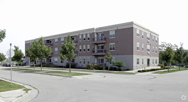
1301 School St
Madison, WI
Liberty Square
0911-314-0261-2
LIBERTY SQUARE LOT 231 SUBJ TO & TOG W/DRIVEWAY ESMT IN DOC #4010925 TOG W/ESMT AGRMT IN DOC #4797687
Commercialnec
Dane
X
Wisconsin
55025C0280J
231
2024
0.95 AC
2024
Liberty Square
011507
Milwaukee/Madison
53,669 SF
DEMOGRAPHICS near 1301 School St
1 Mile
3 Mile
5 Mile
2024 Total Population
8,537
40,339
52,246
2029 Population
8,834
41,869
54,321
Pop Growth 2024-2029
+ 3.48%
+ 3.79%
+ 3.97%
Average Age
38
38
38
2024 Total Households
3,226
15,784
20,866
HH Growth 2024-2029
+ 3.56%
+ 3.95%
+ 4.15%
Median Household Inc
$87,661
$88,631
$90,428
Avg Household Size
2.60
2.50
2.40
2024 Avg HH Vehicles
2.00
2.00
2.00
Median Home Value
$319,461
$322,047
$323,759
Median Year Built
1995
1994
1996
Nearby Places
Map Layers
Map Styles
 Street
 Aerial
- Restaurants
- Banks
- Shops
- Fitness
- Groceries
PUBLIC TRANSPORTATION
AIRPORT
Dane County Regional/Truax Field
DRIVE
WALK
Distance
Dane County Regional/Truax Field
20 min
11.0 mi
Freight Ports
Port Milwaukee
DRIVE
WALK
Distance
Port Milwaukee
94 min
76.8 mi
Nearby Properties
Address
Land Use
TOTAL SIZE
Lot Size
Zoning
Address
Land Use
TOTAL SIZE
Lot Size
Zoning
8.49 AC
SFR
Address
Land Use
TOTAL SIZE
Lot Size
Zoning
Address
Land Use
TOTAL SIZE
Lot Size
Zoning
58,272 SF
136.54 AC
SO
Address
Land Use
TOTAL SIZE
Lot Size
Zoning
8.56 AC
Address
Land Use
TOTAL SIZE
Lot Size
Zoning
26.32 AC
Address
Land Use
TOTAL SIZE
Lot Size
Zoning
4.64 AC
Address
Land Use
TOTAL SIZE
Lot Size
Zoning
31,986 SF
5 AC
PD
Address
Land Use
TOTAL SIZE
Lot Size
Zoning
46,902 SF
5.28 AC
PD
Address
Land Use
TOTAL SIZE
Lot Size
Zoning
Address
Land Use
TOTAL SIZE
Lot Size
Zoning
Address
Land Use
TOTAL SIZE
Lot Size
Zoning
70,080 SF
3.21 AC
Address
Land Use
TOTAL SIZE
Lot Size
Zoning
26,854 SF
8.25 AC
UR12
Address
Land Use
TOTAL SIZE
Lot Size
Zoning
147,310 SF
14.68 AC
SC
Address
Land Use
TOTAL SIZE
Lot Size
Zoning
12.16 AC
Address
Land Use
TOTAL SIZE
Lot Size
Zoning
72,072 SF
11.78 AC
Address
Land Use
TOTAL SIZE
Lot Size
Zoning
Address
Land Use
TOTAL SIZE
Lot Size
Zoning
430,172 SF
18.33 AC
SI
Address
Land Use
TOTAL SIZE
Lot Size
Zoning
Address
Land Use
TOTAL SIZE
Lot Size
Zoning
15.38 AC
Address
Land Use
TOTAL SIZE
Lot Size
Zoning
133,853 SF
12.95 AC
PD
Address
Land Use
TOTAL SIZE
Lot Size
Zoning
22,866 SF
5.39 AC
PD
Address
Land Use
TOTAL SIZE
Lot Size
Zoning
16,464 SF
7.37 AC
UR12
Address
Land Use
TOTAL SIZE
Lot Size
Zoning
2.80 AC
PD
Address
Land Use
TOTAL SIZE
Lot Size
Zoning
55,581 SF
3.35 AC
PD
Address
Land Use
TOTAL SIZE
Lot Size
Zoning
155,550 SF
21.13 AC
SI
Address
Land Use
TOTAL SIZE
Lot Size
Zoning
24.49 AC
Address
Land Use
TOTAL SIZE
Lot Size
Zoning
15.24 AC
ABA
Address
Land Use
TOTAL SIZE
Lot Size
Zoning
15,288 SF
14.55 AC
UR12
Address
Land Use
TOTAL SIZE
Lot Size
Zoning
20,560 SF
6.63 AC
UR12
Address
Land Use
TOTAL SIZE
Lot Size
Zoning
39,676 SF
2.57 AC
UC
The World's #1 Commercial Real Estate Marketplace
Connect with us
© 2025 CoStar Group
The information above has been obtained from sources believed reliable. While we do not doubt its accuracy we have not verified it and make no guarantee, warranty or representation about it. It is your responsibility to independently confirm its accuracy and completeness. Any projections, opinions, assumptions, or estimates used are for example only and do not represent the current or future performance of the property. The value of this transaction to you depends on tax and other factors which should be evaluated by your tax, financial, and legal advisors. You and your advisors should conduct a careful, independent investigation of the property to determine to your satisfaction the suitability of the property for your needs.