Property Record
1301 W 2Nd St, Oconomowoc, WI 53066


NEARBY LISTINGS FOR SALE OR LEASE
-
-
View all Oconomowoc listings for sale on LoopNet.com
Property Detail
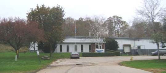
1301 W 2Nd St
Milwaukee-Waukesha-West Allis, WI
Chord Bears
OCOC-0556-993
PT NE1/4 OF SE1/4 SEC 31 T8N R17E; COM NE COR SE1/4 SEC 31; S010957E ALG E LI OF SE1/4 1166.95 FT TO SLY LI WEPCO R/W THE BGN; ALG E LI S010957E 148.50 FT TO SE COR NE1/4 OF SE1/4; S894636W ALG S LI OF NE1/4 OF SE1/4 1220.07 FT TO POINT BEING N894636
Industrialgeneral
Waukesha
X
Wisconsin
55133C0132G
8
2024
9 AC
2024
NE/Delafield
204202
Milwaukee/Madison
DEMOGRAPHICS near 1301 W 2Nd St
1 Mile
3 Mile
5 Mile
2024 Total Population
5,120
21,844
35,529
2029 Population
5,293
22,735
36,802
Pop Growth 2024-2029
+ 3.38%
+ 4.08%
+ 3.58%
Average Age
43
42
43
2024 Total Households
2,099
9,080
14,399
HH Growth 2024-2029
+ 3.33%
+ 4.15%
+ 3.71%
Median Household Inc
$102,769
$94,127
$100,657
Avg Household Size
2.40
2.40
2.40
2024 Avg HH Vehicles
2.00
2.00
2.00
Median Home Value
$322,396
$322,215
$358,070
Median Year Built
1983
1984
1987
Nearby Places
Map Layers
Map Styles
 Street
 Aerial
- Restaurants
- Banks
- Shops
- Fitness
- Groceries
PUBLIC TRANSPORTATION
AIRPORT
General Mitchell International
DRIVE
WALK
Distance
General Mitchell International
59 min
40.0 mi
Freight Ports
Port Milwaukee
DRIVE
WALK
Distance
Port Milwaukee
52 min
36.6 mi
Nearby Properties
Address
Land Use
TOTAL SIZE
Lot Size
Zoning
Address
Land Use
TOTAL SIZE
Lot Size
Zoning
Address
Land Use
TOTAL SIZE
Lot Size
Zoning
Address
Land Use
TOTAL SIZE
Lot Size
Zoning
Address
Land Use
TOTAL SIZE
Lot Size
Zoning
Address
Land Use
TOTAL SIZE
Lot Size
Zoning
8.92 AC
Address
Land Use
TOTAL SIZE
Lot Size
Zoning
22.10 AC
Address
Land Use
TOTAL SIZE
Lot Size
Zoning
Address
Land Use
TOTAL SIZE
Lot Size
Zoning
Address
Land Use
TOTAL SIZE
Lot Size
Zoning
Address
Land Use
TOTAL SIZE
Lot Size
Zoning
Address
Land Use
TOTAL SIZE
Lot Size
Zoning
3.52 AC
Address
Land Use
TOTAL SIZE
Lot Size
Zoning
Address
Land Use
TOTAL SIZE
Lot Size
Zoning
Address
Land Use
TOTAL SIZE
Lot Size
Zoning
5.18 AC
Address
Land Use
TOTAL SIZE
Lot Size
Zoning
1.28 AC
Address
Land Use
TOTAL SIZE
Lot Size
Zoning
Address
Land Use
TOTAL SIZE
Lot Size
Zoning
Address
Land Use
TOTAL SIZE
Lot Size
Zoning
1.57 AC
Address
Land Use
TOTAL SIZE
Lot Size
Zoning
4.70 AC
Address
Land Use
TOTAL SIZE
Lot Size
Zoning
Address
Land Use
TOTAL SIZE
Lot Size
Zoning
Address
Land Use
TOTAL SIZE
Lot Size
Zoning
1.42 AC
Address
Land Use
TOTAL SIZE
Lot Size
Zoning
2.31 AC
Address
Land Use
TOTAL SIZE
Lot Size
Zoning
6.85 AC
Address
Land Use
TOTAL SIZE
Lot Size
Zoning
4.35 AC
Address
Land Use
TOTAL SIZE
Lot Size
Zoning
Address
Land Use
TOTAL SIZE
Lot Size
Zoning
Address
Land Use
TOTAL SIZE
Lot Size
Zoning
2.64 AC
Address
Land Use
TOTAL SIZE
Lot Size
Zoning
Address
Land Use
TOTAL SIZE
Lot Size
Zoning
3.83 AC
The World's #1 Commercial Real Estate Marketplace
Connect with us
© 2026 CoStar Group
The information above has been obtained from sources believed reliable. While we do not doubt its accuracy we have not verified it and make no guarantee, warranty or representation about it. It is your responsibility to independently confirm its accuracy and completeness. Any projections, opinions, assumptions, or estimates used are for example only and do not represent the current or future performance of the property. The value of this transaction to you depends on tax and other factors which should be evaluated by your tax, financial, and legal advisors. You and your advisors should conduct a careful, independent investigation of the property to determine to your satisfaction the suitability of the property for your needs.