Property Record
13010 W 159Th St, Homer Glen, IL 60491

NEARBY LISTINGS FOR SALE OR LEASE
-
-
View all Homer Glen listings for sale on LoopNet.com
Property Detail
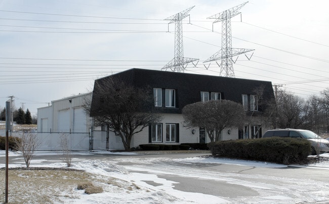
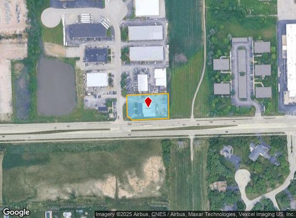
13010 W 159Th St
Chicago-Naperville-Elgin, IL-IN-WI
Annico Professional Complex
16-05-14-404-050
LOT 1 IN ANNICO PROFESSIONAL COMPLEX, A SUB OF PRT OF THE W1/2 OF THE SE1/4 OF SEC. 14, T36N-R11E. (EX THAT PRT TAKEN FOR ROA
Industrialgeneral
Will
X
Illinois
17197C0185G
1
2024
0.83 AC
2024
Joliet Area
881012
Chicago
9,425 SF
DEMOGRAPHICS near 13010 W 159Th St
1 Mile
3 Mile
5 Mile
2024 Total Population
3,192
36,102
102,005
2029 Population
3,175
35,740
100,484
Pop Growth 2024-2029
(0.53%)
(1.00%)
(1.49%)
Average Age
42
43
42
2024 Total Households
1,064
12,550
36,281
HH Growth 2024-2029
(0.47%)
(1.15%)
(1.69%)
Median Household Inc
$120,801
$113,179
$105,820
Avg Household Size
2.90
2.80
2.80
2024 Avg HH Vehicles
3.00
2.00
2.00
Median Home Value
$384,624
$363,636
$359,194
Median Year Built
1991
1992
1993
Nearby Places
Map Layers
Map Styles
 Street
 Aerial
- Restaurants
- Banks
- Shops
- Fitness
- Groceries
PUBLIC TRANSPORTATION
COMMUTER RAIL
Orland Park - 153Rd Street Station (SouthWest Service - Northeast Illinois Regional Commuter Railroad (Metra))
DRIVE
WALK
Distance
Orland Park - 153Rd Street Station (SouthWest Service - Northeast Illinois Regional Commuter Railroad (Metra))
10 min
4.3 mi
Orland Park - 179Th Street Station (SouthWest Service - Northeast Illinois Regional Commuter Railroad (Metra))
DRIVE
WALK
Distance
Orland Park - 179Th Street Station (SouthWest Service - Northeast Illinois Regional Commuter Railroad (Metra))
9 min
5.3 mi
AIRPORT
Chicago Midway International
DRIVE
WALK
Distance
Chicago Midway International
34 min
21.7 mi
Chicago O'Hare International
DRIVE
WALK
Distance
Chicago O'Hare International
51 min
33.2 mi
Freight Ports
Port Milwaukee
DRIVE
WALK
Distance
Port Milwaukee
132 min
104.9 mi
Nearby Properties
Address
Land Use
TOTAL SIZE
Lot Size
Zoning
Address
Land Use
TOTAL SIZE
Lot Size
Zoning
20.43 AC
Address
Land Use
TOTAL SIZE
Lot Size
Zoning
8,577 SF
160 AC
Address
Land Use
TOTAL SIZE
Lot Size
Zoning
13.73 AC
Address
Land Use
TOTAL SIZE
Lot Size
Zoning
166,107 SF
16.17 AC
Address
Land Use
TOTAL SIZE
Lot Size
Zoning
143.93 AC
Address
Land Use
TOTAL SIZE
Lot Size
Zoning
103,164 SF
10.87 AC
Address
Land Use
TOTAL SIZE
Lot Size
Zoning
30,540 SF
5.34 AC
Address
Land Use
TOTAL SIZE
Lot Size
Zoning
60,698 SF
8.63 AC
Address
Land Use
TOTAL SIZE
Lot Size
Zoning
3.16 AC
Address
Land Use
TOTAL SIZE
Lot Size
Zoning
13,373 SF
3.78 AC
Address
Land Use
TOTAL SIZE
Lot Size
Zoning
41,449 SF
3.26 AC
Address
Land Use
TOTAL SIZE
Lot Size
Zoning
3,838 SF
4.77 AC
Address
Land Use
TOTAL SIZE
Lot Size
Zoning
67,683 SF
5.73 AC
Address
Land Use
TOTAL SIZE
Lot Size
Zoning
49,294 SF
6.05 AC
Address
Land Use
TOTAL SIZE
Lot Size
Zoning
92,947 SF
7.49 AC
Address
Land Use
TOTAL SIZE
Lot Size
Zoning
76,322 SF
4.36 AC
Address
Land Use
TOTAL SIZE
Lot Size
Zoning
70,165 SF
3.92 AC
Address
Land Use
TOTAL SIZE
Lot Size
Zoning
24,140 SF
1.76 AC
Address
Land Use
TOTAL SIZE
Lot Size
Zoning
2,066 SF
2.50 AC
Address
Land Use
TOTAL SIZE
Lot Size
Zoning
26,415 SF
3.46 AC
Address
Land Use
TOTAL SIZE
Lot Size
Zoning
15,150 SF
1.40 AC
Address
Land Use
TOTAL SIZE
Lot Size
Zoning
11.42 AC
Address
Land Use
TOTAL SIZE
Lot Size
Zoning
1.61 AC
Address
Land Use
TOTAL SIZE
Lot Size
Zoning
Address
Land Use
TOTAL SIZE
Lot Size
Zoning
4,718 SF
2.80 AC
Address
Land Use
TOTAL SIZE
Lot Size
Zoning
22,592 SF
78.60 AC
Address
Land Use
TOTAL SIZE
Lot Size
Zoning
Address
Land Use
TOTAL SIZE
Lot Size
Zoning
21,522 SF
4.85 AC
Address
Land Use
TOTAL SIZE
Lot Size
Zoning
0.52 AC
Address
Land Use
TOTAL SIZE
Lot Size
Zoning
13,470 SF
2.88 AC
The World's #1 Commercial Real Estate Marketplace
Connect with us
© 2025 CoStar Group
The information above has been obtained from sources believed reliable. While we do not doubt its accuracy we have not verified it and make no guarantee, warranty or representation about it. It is your responsibility to independently confirm its accuracy and completeness. Any projections, opinions, assumptions, or estimates used are for example only and do not represent the current or future performance of the property. The value of this transaction to you depends on tax and other factors which should be evaluated by your tax, financial, and legal advisors. You and your advisors should conduct a careful, independent investigation of the property to determine to your satisfaction the suitability of the property for your needs.