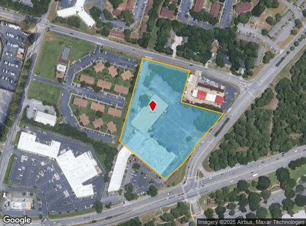
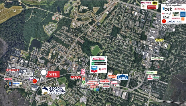
Property Record
12052 Middleground Rd, Savannah, GA 31419
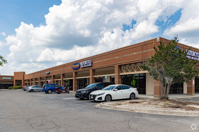
This Property Is For Sale
NEARBY LISTINGS FOR SALE OR LEASE
Property Detail
12052 Middleground Rd
Savannah, GA
Sub
2084501007
PT OF LT B SUB OF LTS 35 THRU 3 8 & PT OF LOTS 34 & 39 VERNON H
Communitycenter
Chatham
X
Georgia
13051C0256G
b,35,34
2024
6.88 AC
2025
Greater Savannah
010901
Savannah
72,978 SF
DEMOGRAPHICS near 12052 Middleground Rd
1 Mile
3 Mile
5 Mile
2024 Total Population
8,192
34,708
78,065
2029 Population
8,496
35,698
80,595
Pop Growth 2024-2029
+ 3.71%
+ 2.85%
+ 3.24%
Average Age
39
39
39
2024 Total Households
3,316
14,409
32,016
HH Growth 2024-2029
+ 4.13%
+ 3.01%
+ 3.34%
Median Household Inc
$44,216
$56,220
$57,151
Avg Household Size
2.10
2.20
2.30
2024 Avg HH Vehicles
1.00
2.00
2.00
Median Home Value
$149,591
$170,131
$191,561
Median Year Built
1981
1982
1984
Nearby Places
Map Layers
Map Styles
 Street
 Aerial
- Restaurants
- Banks
- Shops
- Fitness
- Groceries
PUBLIC TRANSPORTATION
AIRPORT
Savannah/Hilton Head International
DRIVE
WALK
Distance
Savannah/Hilton Head International
29 min
16.0 mi
Freight Ports
Georgia Ports - Savannah
DRIVE
WALK
Distance
Georgia Ports - Savannah
25 min
14.8 mi
Nearby Properties
Address
Land Use
TOTAL SIZE
Lot Size
Zoning
Address
Land Use
TOTAL SIZE
Lot Size
Zoning
99.50 AC
M
Address
Land Use
TOTAL SIZE
Lot Size
Zoning
19,432 SF
214.77 AC
R3
Address
Land Use
TOTAL SIZE
Lot Size
Zoning
70.49 AC
M
Address
Land Use
TOTAL SIZE
Lot Size
Zoning
942,210 SF
50.60 AC
Address
Land Use
TOTAL SIZE
Lot Size
Zoning
565,144 SF
19.74 AC
I-P
Address
Land Use
TOTAL SIZE
Lot Size
Zoning
413,230 SF
39.64 AC
M-CO
Address
Land Use
TOTAL SIZE
Lot Size
Zoning
18,138 SF
12.80 AC
RM25
Address
Land Use
TOTAL SIZE
Lot Size
Zoning
16,896 SF
11.32 AC
IP
Address
Land Use
TOTAL SIZE
Lot Size
Zoning
7,344 SF
13.09 AC
RM25
Address
Land Use
TOTAL SIZE
Lot Size
Zoning
14,249 SF
14.92 AC
BC
Address
Land Use
TOTAL SIZE
Lot Size
Zoning
8,064 SF
14.70 AC
RM25
Address
Land Use
TOTAL SIZE
Lot Size
Zoning
13,920 SF
14.50 AC
RM25
Address
Land Use
TOTAL SIZE
Lot Size
Zoning
16,138 SF
18.33 AC
PUDC
Address
Land Use
TOTAL SIZE
Lot Size
Zoning
2,033 SF
45.50 AC
R1
Address
Land Use
TOTAL SIZE
Lot Size
Zoning
17.78 AC
R1
Address
Land Use
TOTAL SIZE
Lot Size
Zoning
6,812 SF
9.48 AC
RM25
Address
Land Use
TOTAL SIZE
Lot Size
Zoning
6,296 SF
15.09 AC
PUDM15
Address
Land Use
TOTAL SIZE
Lot Size
Zoning
10,200 SF
12.79 AC
RM25
Address
Land Use
TOTAL SIZE
Lot Size
Zoning
7,256 SF
8.73 AC
RM25
Address
Land Use
TOTAL SIZE
Lot Size
Zoning
10,965 SF
17.34 AC
PUDM25
Address
Land Use
TOTAL SIZE
Lot Size
Zoning
13,824 SF
9.50 AC
R3
Address
Land Use
TOTAL SIZE
Lot Size
Zoning
13,152 SF
11.22 AC
RM25
Address
Land Use
TOTAL SIZE
Lot Size
Zoning
25,864 SF
8.04 AC
PBC
Address
Land Use
TOTAL SIZE
Lot Size
Zoning
38,268 SF
7.65 AC
RM25
Address
Land Use
TOTAL SIZE
Lot Size
Zoning
28.95 AC
M
Address
Land Use
TOTAL SIZE
Lot Size
Zoning
71,502 SF
10.60 AC
PUDIS
Address
Land Use
TOTAL SIZE
Lot Size
Zoning
124,110 SF
17.38 AC
PUDB
Address
Land Use
TOTAL SIZE
Lot Size
Zoning
25 AC
R6
Address
Land Use
TOTAL SIZE
Lot Size
Zoning
18,800 SF
8.71 AC
PUDC
Address
Land Use
TOTAL SIZE
Lot Size
Zoning
4,576 SF
20 AC
PUDM12
The World's #1 Commercial Real Estate Marketplace
Connect with us
© 2025 CoStar Group
The information above has been obtained from sources believed reliable. While we do not doubt its accuracy we have not verified it and make no guarantee, warranty or representation about it. It is your responsibility to independently confirm its accuracy and completeness. Any projections, opinions, assumptions, or estimates used are for example only and do not represent the current or future performance of the property. The value of this transaction to you depends on tax and other factors which should be evaluated by your tax, financial, and legal advisors. You and your advisors should conduct a careful, independent investigation of the property to determine to your satisfaction the suitability of the property for your needs.