Property Record
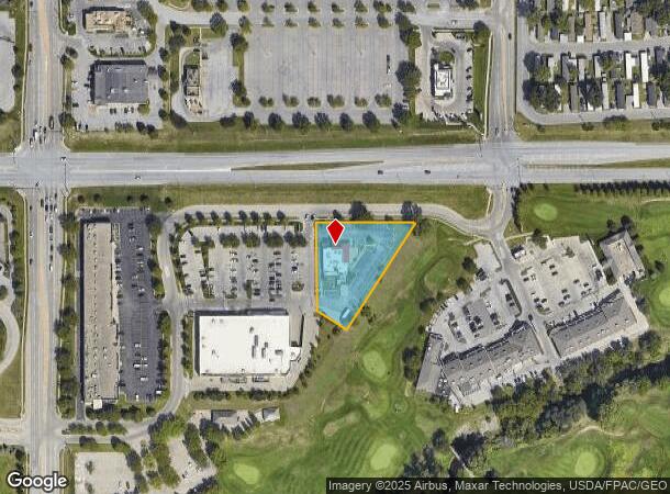
13015 Birch Dr, Omaha, NE 68164

NEARBY LISTINGS FOR SALE OR LEASE
Property Detail
13015 Birch Dr
Omaha-Council Bluffs, NE-IA
Eagle Run Commercial Sub
0385-6505-10
EAGLE RUN COMMERCIAL SUB REP 1* LOT 2 BLOCK 0 IRREG
Restaurantbuilding
Douglas
X
Nebraska
31055C0211H
2
2024
1.10 AC
2025
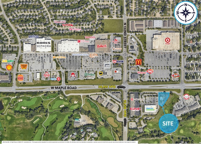
Northwest Omaha
007439
Omaha/Council Bluffs
5,775 SF
DEMOGRAPHICS near 13015 Birch Dr
1 Mile
3 Mile
5 Mile
2024 Total Population
10,654
93,848
210,341
2029 Population
10,705
94,815
213,535
Pop Growth 2024-2029
+ 0.48%
+ 1.03%
+ 1.52%
Average Age
41
39
39
2024 Total Households
4,521
38,502
84,218
HH Growth 2024-2029
+ 0.51%
+ 1.04%
+ 1.47%
Median Household Inc
$91,539
$82,820
$86,248
Avg Household Size
2.30
2.40
2.40
2024 Avg HH Vehicles
2.00
2.00
2.00
Median Home Value
$232,768
$253,082
$258,690
Median Year Built
1991
1990
1987
Nearby Places
Map Layers
Map Styles
 Street
 Aerial
- Restaurants
- Banks
- Shops
- Fitness
- Groceries
PUBLIC TRANSPORTATION
AIRPORT
Eppley Airfield
DRIVE
WALK
Distance
Eppley Airfield
28 min
14.5 mi
SALE & LEASE HISTORY
LISTING DATE
SALE/LEASE

Nov 30, 2018
For Lease
Nov 13, 2018
For Lease
Mar 05, 2025
For Lease
Nearby Properties
Address
Land Use
TOTAL SIZE
Lot Size
Zoning
Address
Land Use
TOTAL SIZE
Lot Size
Zoning
496,976 SF
12 AC
Address
Land Use
TOTAL SIZE
Lot Size
Zoning
856,187 SF
36.41 AC
Address
Land Use
TOTAL SIZE
Lot Size
Zoning
549,971 SF
42.84 AC
R6
Address
Land Use
TOTAL SIZE
Lot Size
Zoning
584,213 SF
36.38 AC
R7
Address
Land Use
TOTAL SIZE
Lot Size
Zoning
548,510 SF
36.78 AC
Address
Land Use
TOTAL SIZE
Lot Size
Zoning
396,428 SF
14.45 AC
R6
Address
Land Use
TOTAL SIZE
Lot Size
Zoning
545,041 SF
22.69 AC
R6
Address
Land Use
TOTAL SIZE
Lot Size
Zoning
239,976 SF
20.13 AC
Address
Land Use
TOTAL SIZE
Lot Size
Zoning
311,856 SF
19.22 AC
Address
Land Use
TOTAL SIZE
Lot Size
Zoning
250,386 SF
17.06 AC
Address
Land Use
TOTAL SIZE
Lot Size
Zoning
301,341 SF
15.04 AC
R6
Address
Land Use
TOTAL SIZE
Lot Size
Zoning
428,342 SF
18.62 AC
Address
Land Use
TOTAL SIZE
Lot Size
Zoning
329,565 SF
7.72 AC
Address
Land Use
TOTAL SIZE
Lot Size
Zoning
460,264 SF
20.87 AC
Address
Land Use
TOTAL SIZE
Lot Size
Zoning
186,653 SF
7.96 AC
Address
Land Use
TOTAL SIZE
Lot Size
Zoning
233,882 SF
9.49 AC
MU
Address
Land Use
TOTAL SIZE
Lot Size
Zoning
339,557 SF
12.89 AC
R7
Address
Land Use
TOTAL SIZE
Lot Size
Zoning
350,925 SF
12.71 AC
Address
Land Use
TOTAL SIZE
Lot Size
Zoning
255,483 SF
14.25 AC
Address
Land Use
TOTAL SIZE
Lot Size
Zoning
420,264 SF
23.97 AC
R6
Address
Land Use
TOTAL SIZE
Lot Size
Zoning
261,247 SF
13.20 AC
Address
Land Use
TOTAL SIZE
Lot Size
Zoning
376,653 SF
7.36 AC
Address
Land Use
TOTAL SIZE
Lot Size
Zoning
288,432 SF
12.98 AC
Address
Land Use
TOTAL SIZE
Lot Size
Zoning
251,394 SF
14.71 AC
Address
Land Use
TOTAL SIZE
Lot Size
Zoning
136,340 SF
7.50 AC
MU
Address
Land Use
TOTAL SIZE
Lot Size
Zoning
255,205 SF
9.41 AC
R6
Address
Land Use
TOTAL SIZE
Lot Size
Zoning
142,950 SF
5.94 AC
Address
Land Use
TOTAL SIZE
Lot Size
Zoning
248,169 SF
10.39 AC
Address
Land Use
TOTAL SIZE
Lot Size
Zoning
253,742 SF
3.24 AC
LI
Address
Land Use
TOTAL SIZE
Lot Size
Zoning
230,952 SF
8.56 AC
The World's #1 Commercial Real Estate Marketplace
Connect with us
© 2025 CoStar Group
The information above has been obtained from sources believed reliable. While we do not doubt its accuracy we have not verified it and make no guarantee, warranty or representation about it. It is your responsibility to independently confirm its accuracy and completeness. Any projections, opinions, assumptions, or estimates used are for example only and do not represent the current or future performance of the property. The value of this transaction to you depends on tax and other factors which should be evaluated by your tax, financial, and legal advisors. You and your advisors should conduct a careful, independent investigation of the property to determine to your satisfaction the suitability of the property for your needs.