Property Record
13018 N Research Blvd, Austin, TX 78759
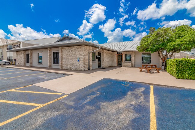

Property Detail
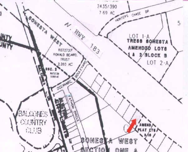
13018 N Research Blvd
R072693
SONESTA WEST SEC 1A, BLOCK G, LOT 7 PT, ACRES .4039
Commercialnec
WILLIAMSON
4-GR
Texas
B and X Area of moderate flood hazard, usually the area between the limits of the 100-year and 500-year floods.
7
2024
0.40 AC
2025
Far Northwest
030800
Austin
5,751 SF
Austin-Round Rock-San Marcos, TX
NEARBY LISTINGS FOR SALE OR LEASE
DEMOGRAPHICS near 13018 N Research Blvd
1 mile
3 mile
5 mile
2025 Total Population
18,645
101,791
226,279
2030 Population
20,644
110,387
244,997
Pop Growth 2025-2030
+ 10.72%
+ 8.44%
+ 8.27%
Average Age
38
38
38
2025 Total Households
8,689
44,925
99,820
HH Growth 2025-2030
+ 11.91%
+ 9.29%
+ 8.73%
Median Household Inc
$81,013
$105,636
$107,632
Avg Household Size
2.10
2.20
2.20
2025 Avg HH Vehicles
2.00
2.00
2.00
Median Home Value
$645,396
$617,810
$640,696
Median Year Built
1990
1993
1997
Nearby Places
Map Layers
Map Styles
 Street
 Aerial
Transit
 Traffic
 Biking
Places
Listings with unknown addresses are not visible on the map
- Restaurants
- Banks
- Shops
- Fitness
- Groceries
PUBLIC TRANSPORTATION
AIRPORT
Austin-Bergstrom International
Drive
Walk
Distance
Austin-Bergstrom International
36 min
25.1 mi
SALE & LEASE HISTORY
LISTING DATE
SALE/LEASE

Sep 25, 2016
For Lease
Sep 09, 2020
For Sale
May 25, 2017
For Lease
Mar 07, 2022
For Lease
Jul 18, 2018
For Lease
Jul 17, 2018
For Sale
Nearby Properties
Address
Land Use
TOTAL SIZE
Lot Size
Zoning
Address
Land Use
TOTAL SIZE
Lot Size
Zoning
3,601,391 SF
159.61 AC
Address
Land Use
TOTAL SIZE
Lot Size
Zoning
13,523 SF
128.82 AC
Address
Land Use
TOTAL SIZE
Lot Size
Zoning
535,000 SF
24.46 AC
Address
Land Use
TOTAL SIZE
Lot Size
Zoning
830,637 SF
23.22 AC
Address
Land Use
TOTAL SIZE
Lot Size
Zoning
462,651 SF
81.77 AC
Address
Land Use
TOTAL SIZE
Lot Size
Zoning
557,037 SF
29.48 AC
Address
Land Use
TOTAL SIZE
Lot Size
Zoning
492,227 SF
23.59 AC
Address
Land Use
TOTAL SIZE
Lot Size
Zoning
376,081 SF
8.62 AC
Address
Land Use
TOTAL SIZE
Lot Size
Zoning
363,544 SF
8.54 AC
Address
Land Use
TOTAL SIZE
Lot Size
Zoning
381,408 SF
22.17 AC
Address
Land Use
TOTAL SIZE
Lot Size
Zoning
1,179,402 SF
92.28 AC
Address
Land Use
TOTAL SIZE
Lot Size
Zoning
364,130 SF
42.45 AC
Address
Land Use
TOTAL SIZE
Lot Size
Zoning
385,918 SF
23.61 AC
Address
Land Use
TOTAL SIZE
Lot Size
Zoning
285,120 SF
15.60 AC
Address
Land Use
TOTAL SIZE
Lot Size
Zoning
365,399 SF
11.50 AC
Address
Land Use
TOTAL SIZE
Lot Size
Zoning
370,331 SF
14.10 AC
Address
Land Use
TOTAL SIZE
Lot Size
Zoning
277,020 SF
1.41 AC
Address
Land Use
TOTAL SIZE
Lot Size
Zoning
557,037 SF
32.48 AC
Address
Land Use
TOTAL SIZE
Lot Size
Zoning
687,401 SF
20.47 AC
Address
Land Use
TOTAL SIZE
Lot Size
Zoning
400,536 SF
31.68 AC
Address
Land Use
TOTAL SIZE
Lot Size
Zoning
468,870 SF
22 AC
4-GRMUCO
Address
Land Use
TOTAL SIZE
Lot Size
Zoning
644,443 SF
7.02 AC
Address
Land Use
TOTAL SIZE
Lot Size
Zoning
331,086 SF
17.23 AC
Address
Land Use
TOTAL SIZE
Lot Size
Zoning
381,556 SF
21.50 AC
Address
Land Use
TOTAL SIZE
Lot Size
Zoning
303,280 SF
16.96 AC
Address
Land Use
TOTAL SIZE
Lot Size
Zoning
1,152,630 SF
23.29 AC
Address
Land Use
TOTAL SIZE
Lot Size
Zoning
369,126 SF
29.50 AC
Address
Land Use
TOTAL SIZE
Lot Size
Zoning
410,378 SF
21.43 AC
Address
Land Use
TOTAL SIZE
Lot Size
Zoning
277,022 SF
14.10 AC
Address
Land Use
TOTAL SIZE
Lot Size
Zoning
288,750 SF
15.38 AC
The World's #1 Commercial Real Estate Marketplace
Connect with us
© 2026 CoStar Group
The information above has been obtained from sources believed reliable. While we do not doubt its accuracy we have not verified it and make no guarantee, warranty or representation about it. It is your responsibility to independently confirm its accuracy and completeness. Any projections, opinions, assumptions, or estimates used are for example only and do not represent the current or future performance of the property. The value of this transaction to you depends on tax and other factors which should be evaluated by your tax, financial, and legal advisors. You and your advisors should conduct a careful, independent investigation of the property to determine to your satisfaction the suitability of the property for your needs.