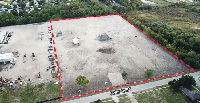
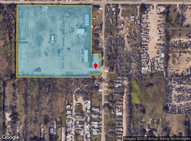
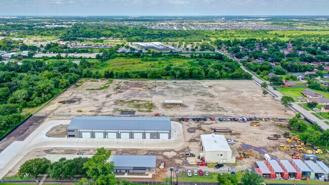
Property Record
13020 Donegal Way, Houston, TX 77047
NEARBY LISTINGS FOR SALE OR LEASE
Property Detail
13020 Donegal Way
Houston-Pasadena-The Woodlands, TX
Minnetex Place
0261120000052
LT 52 MINNETEX PLACE
Commercialnec
Harris
X
Texas
48039C0030K
52
2024
10 AC
2024
South
331502
Houston
DEMOGRAPHICS near 13020 Donegal Way
1 Mile
3 Mile
5 Mile
2024 Total Population
8,944
67,331
207,844
2029 Population
9,179
69,512
217,591
Pop Growth 2024-2029
+ 2.63%
+ 3.24%
+ 4.69%
Average Age
38
37
36
2024 Total Households
3,074
24,068
72,553
HH Growth 2024-2029
+ 2.37%
+ 3.22%
+ 4.78%
Median Household Inc
$63,149
$53,540
$57,965
Avg Household Size
2.80
2.70
2.80
2024 Avg HH Vehicles
2.00
2.00
2.00
Median Home Value
$156,105
$167,895
$173,120
Median Year Built
1994
1995
1992
Nearby Places
Map Layers
Map Styles
 Street
 Aerial
- Restaurants
- Banks
- Shops
- Fitness
- Groceries
PUBLIC TRANSPORTATION
AIRPORT
William P Hobby
DRIVE
WALK
Distance
William P Hobby
16 min
6.8 mi
George Bush Intcntl/Houston
DRIVE
WALK
Distance
George Bush Intcntl/Houston
41 min
30.7 mi
Freight Ports
Port of Houston
DRIVE
WALK
Distance
Port of Houston
24 min
13.5 mi
SALE & LEASE HISTORY
LISTING DATE
SALE/LEASE

Feb 22, 2023
For Lease
Apr 04, 2025
For Lease
Nearby Properties
Address
Land Use
TOTAL SIZE
Lot Size
Zoning
Address
Land Use
TOTAL SIZE
Lot Size
Zoning
1,226,700 SF
92.85 AC
Address
Land Use
TOTAL SIZE
Lot Size
Zoning
567,513 SF
5.82 AC
Address
Land Use
TOTAL SIZE
Lot Size
Zoning
603,780 SF
36.94 AC
Address
Land Use
TOTAL SIZE
Lot Size
Zoning
375,863 SF
16.35 AC
Address
Land Use
TOTAL SIZE
Lot Size
Zoning
421,680 SF
23.44 AC
Address
Land Use
TOTAL SIZE
Lot Size
Zoning
413,336 SF
24.57 AC
Address
Land Use
TOTAL SIZE
Lot Size
Zoning
273,854 SF
9.57 AC
Address
Land Use
TOTAL SIZE
Lot Size
Zoning
217,822 SF
8.12 AC
Address
Land Use
TOTAL SIZE
Lot Size
Zoning
202,500 SF
30.60 AC
Address
Land Use
TOTAL SIZE
Lot Size
Zoning
228,288 SF
10.32 AC
Address
Land Use
TOTAL SIZE
Lot Size
Zoning
316,800 SF
16.03 AC
Address
Land Use
TOTAL SIZE
Lot Size
Zoning
387,389 SF
21.40 AC
Address
Land Use
TOTAL SIZE
Lot Size
Zoning
206,777 SF
8.14 AC
Address
Land Use
TOTAL SIZE
Lot Size
Zoning
268,425 SF
17.47 AC
Address
Land Use
TOTAL SIZE
Lot Size
Zoning
299,046 SF
Address
Land Use
TOTAL SIZE
Lot Size
Zoning
163,644 SF
8.40 AC
Address
Land Use
TOTAL SIZE
Lot Size
Zoning
231,696 SF
Address
Land Use
TOTAL SIZE
Lot Size
Zoning
264,384 SF
13.76 AC
Address
Land Use
TOTAL SIZE
Lot Size
Zoning
130,498 SF
93.44 AC
Address
Land Use
TOTAL SIZE
Lot Size
Zoning
65,854 SF
18.96 AC
Address
Land Use
TOTAL SIZE
Lot Size
Zoning
190,172 SF
14.71 AC
Address
Land Use
TOTAL SIZE
Lot Size
Zoning
239,458 SF
15.57 AC
Address
Land Use
TOTAL SIZE
Lot Size
Zoning
137,267 SF
23.69 AC
Address
Land Use
TOTAL SIZE
Lot Size
Zoning
193,500 SF
9.46 AC
Address
Land Use
TOTAL SIZE
Lot Size
Zoning
367,096 SF
15.76 AC
Address
Land Use
TOTAL SIZE
Lot Size
Zoning
215,900 SF
11.93 AC
Address
Land Use
TOTAL SIZE
Lot Size
Zoning
199,360 SF
11.13 AC
Address
Land Use
TOTAL SIZE
Lot Size
Zoning
161,000 SF
9.82 AC
Address
Land Use
TOTAL SIZE
Lot Size
Zoning
117,404 SF
Address
Land Use
TOTAL SIZE
Lot Size
Zoning
210,870 SF
13.07 AC
The World's #1 Commercial Real Estate Marketplace
Connect with us
© 2026 CoStar Group
The information above has been obtained from sources believed reliable. While we do not doubt its accuracy we have not verified it and make no guarantee, warranty or representation about it. It is your responsibility to independently confirm its accuracy and completeness. Any projections, opinions, assumptions, or estimates used are for example only and do not represent the current or future performance of the property. The value of this transaction to you depends on tax and other factors which should be evaluated by your tax, financial, and legal advisors. You and your advisors should conduct a careful, independent investigation of the property to determine to your satisfaction the suitability of the property for your needs.