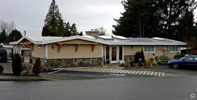
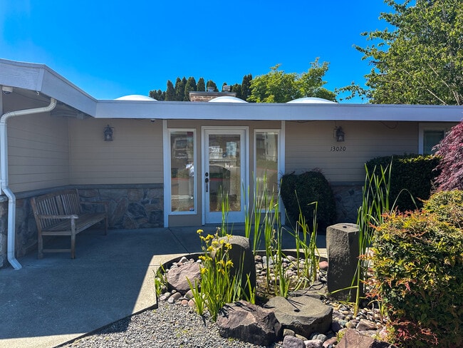
Property Record
13020 Ne 85Th St, Kirkland, WA 98033
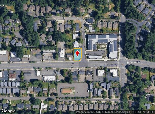

NEARBY LISTINGS FOR SALE OR LEASE
Property Detail
13020 Ne 85Th St
Seattle-Tacoma-Bellevue, WA
Three Pines Add Div No. 02
863570-0010
King
Sfr
Washington
X
0.23 AC
53033C0366H
Kirkland
2,341 SF
Seattle/Puget Sound
DEMOGRAPHICS near 13020 Ne 85Th St
1 Mile
3 Mile
5 Mile
2024 Total Population
13,025
119,826
276,097
2029 Population
13,128
121,709
279,685
Pop Growth 2024-2029
+ 0.79%
+ 1.57%
+ 1.30%
Average Age
38
38
38
2024 Total Households
4,780
50,584
114,343
HH Growth 2024-2029
+ 0.59%
+ 1.61%
+ 1.39%
Median Household Inc
$161,070
$142,407
$147,467
Avg Household Size
2.60
2.30
2.30
2024 Avg HH Vehicles
2.00
2.00
2.00
Median Home Value
$1,004,669
$1,013,368
$1,006,494
Median Year Built
1984
1988
1987
Nearby Places
- Restaurants
- Banks
- Shops
- Fitness
- Groceries
PUBLIC TRANSPORTATION
AIRPORT
Seattle Paine Field International
DRIVE
WALK
Distance
Seattle Paine Field International
28 min
19.3 mi
Seattle-Tacoma International
DRIVE
WALK
Distance
Seattle-Tacoma International
33 min
22.5 mi
Freight Ports
Port of Seattle
DRIVE
WALK
Distance
Port of Seattle
29 min
18.2 mi
Nearby Properties
Address
Land Use
TOTAL SIZE
Lot Size
Zoning
Address
Land Use
TOTAL SIZE
Lot Size
Zoning
570,472 SF
17.39 AC
TL 3A
Address
Land Use
TOTAL SIZE
Lot Size
Zoning
105,056 SF
15.92 AC
PLA 15A
Address
Land Use
TOTAL SIZE
Lot Size
Zoning
146,798 SF
19.63 AC
OBAT
Address
Land Use
TOTAL SIZE
Lot Size
Zoning
171,186 SF
16.45 AC
OBAT
Address
Land Use
TOTAL SIZE
Lot Size
Zoning
424,532 SF
30.49 AC
OUMF
Address
Land Use
TOTAL SIZE
Lot Size
Zoning
407,216 SF
45.12 AC
PLA 9
Address
Land Use
TOTAL SIZE
Lot Size
Zoning
747,347 SF
8.91 AC
BP
Address
Land Use
TOTAL SIZE
Lot Size
Zoning
295,212 SF
10.57 AC
PLA 3B
Address
Land Use
TOTAL SIZE
Lot Size
Zoning
11,970 SF
4.81 AC
TL 6A
Address
Land Use
TOTAL SIZE
Lot Size
Zoning
572,539 SF
2.50 AC
CBD 5A
Address
Land Use
TOTAL SIZE
Lot Size
Zoning
342,000 SF
24.18 AC
OUMF
Address
Land Use
TOTAL SIZE
Lot Size
Zoning
364,208 SF
16.94 AC
NMF
Address
Land Use
TOTAL SIZE
Lot Size
Zoning
231,088 SF
2.10 AC
TWNC
Address
Land Use
TOTAL SIZE
Lot Size
Zoning
270,158 SF
3.03 AC
TSQ
Address
Land Use
TOTAL SIZE
Lot Size
Zoning
279,488 SF
20.82 AC
NMF
Address
Land Use
TOTAL SIZE
Lot Size
Zoning
422,038 SF
7.01 AC
OBAT
Address
Land Use
TOTAL SIZE
Lot Size
Zoning
793,294 SF
7.07 AC
OBAT
Address
Land Use
TOTAL SIZE
Lot Size
Zoning
209,400 SF
1.80 AC
TSQ
Address
Land Use
TOTAL SIZE
Lot Size
Zoning
65,000 SF
13.57 AC
EH
Address
Land Use
TOTAL SIZE
Lot Size
Zoning
420,705 SF
8.22 AC
OBAT
Address
Land Use
TOTAL SIZE
Lot Size
Zoning
298,849 SF
3.99 AC
OBAT
Address
Land Use
TOTAL SIZE
Lot Size
Zoning
300,628 SF
4.43 AC
OBAT
Address
Land Use
TOTAL SIZE
Lot Size
Zoning
240 SF
471.44 AC
R1
Address
Land Use
TOTAL SIZE
Lot Size
Zoning
141,158 SF
15.81 AC
OBAT
Address
Land Use
TOTAL SIZE
Lot Size
Zoning
393,897 SF
10.05 AC
OBAT
Address
Land Use
TOTAL SIZE
Lot Size
Zoning
125,996 SF
7.57 AC
TWNC
Address
Land Use
TOTAL SIZE
Lot Size
Zoning
136,191 SF
7.23 AC
TWNC
Address
Land Use
TOTAL SIZE
Lot Size
Zoning
278,492 SF
8.02 AC
OBAT
Address
Land Use
TOTAL SIZE
Lot Size
Zoning
15,512 SF
3.03 AC
MDD5
Address
Land Use
TOTAL SIZE
Lot Size
Zoning
98,914 SF
10.38 AC
SMT
The World's #1 Commercial Real Estate Marketplace
Connect with us
© 2025 CoStar Group
The information above has been obtained from sources believed reliable. While we do not doubt its accuracy we have not verified it and make no guarantee, warranty or representation about it. It is your responsibility to independently confirm its accuracy and completeness. Any projections, opinions, assumptions, or estimates used are for example only and do not represent the current or future performance of the property. The value of this transaction to you depends on tax and other factors which should be evaluated by your tax, financial, and legal advisors. You and your advisors should conduct a careful, independent investigation of the property to determine to your satisfaction the suitability of the property for your needs.