Property Record
13025 Route 1 Hwy, Chester, VA 23831

NEARBY LISTINGS FOR SALE OR LEASE
Property Detail
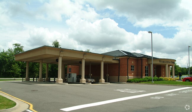
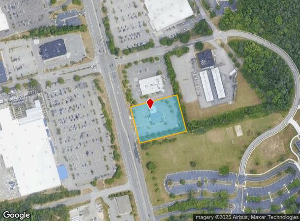
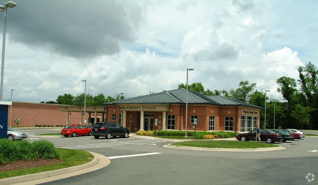
13025 Route 1 Hwy
Richmond, VA
S/E Crn Jeff Davis Hwy Parcel
799-65-26-54-000-000
S/E CRN JEFF DAVIS HY PARCEL 2
Financialbuilding
Chesterfield
X
Virginia
51041C0335E
2
2025
1.65 AC
2025
South Chesterfield
100505
Richmond VA
4,025 SF
DEMOGRAPHICS near 13025 Route 1 Hwy
1 Mile
3 Mile
5 Mile
2024 Total Population
4,019
37,377
78,161
2029 Population
4,389
40,815
85,220
Pop Growth 2024-2029
+ 9.21%
+ 9.20%
+ 9.03%
Average Age
38
39
40
2024 Total Households
1,553
13,971
28,917
HH Growth 2024-2029
+ 9.53%
+ 9.36%
+ 9.33%
Median Household Inc
$78,262
$78,195
$80,676
Avg Household Size
2.60
2.60
2.60
2024 Avg HH Vehicles
2.00
2.00
2.00
Median Home Value
$234,413
$276,877
$277,462
Median Year Built
1992
1991
1991
Nearby Places
Map Layers
Map Styles
 Street
 Aerial
- Restaurants
- Banks
- Shops
- Fitness
- Groceries
PUBLIC TRANSPORTATION
COMMUTER RAIL
DRIVE
WALK
Distance
16 min
8.8 mi
AIRPORT
Richmond International
DRIVE
WALK
Distance
Richmond International
30 min
19.0 mi
Nearby Properties
Address
Land Use
TOTAL SIZE
Lot Size
Zoning
Address
Land Use
TOTAL SIZE
Lot Size
Zoning
32,947 SF
13.38 AC
C5 - GEN B
Address
Land Use
TOTAL SIZE
Lot Size
Zoning
289,964 SF
39.62 AC
R7 - SINGL
Address
Land Use
TOTAL SIZE
Lot Size
Zoning
1.60 AC
RMF - RES,
Address
Land Use
TOTAL SIZE
Lot Size
Zoning
100 SF
36.88 AC
RMF - RES,
Address
Land Use
TOTAL SIZE
Lot Size
Zoning
177,908 SF
13.59 AC
RMF - RES,
Address
Land Use
TOTAL SIZE
Lot Size
Zoning
116,527 SF
25.57 AC
RMF - RES,
Address
Land Use
TOTAL SIZE
Lot Size
Zoning
100 SF
25.80 AC
R7 - SINGL
Address
Land Use
TOTAL SIZE
Lot Size
Zoning
55,952 SF
11.82 AC
C3 - COMMU
Address
Land Use
TOTAL SIZE
Lot Size
Zoning
67,060 SF
4.93 AC
C5 - GEN B
Address
Land Use
TOTAL SIZE
Lot Size
Zoning
261,922 SF
19.85 AC
I1 - LT IN
Address
Land Use
TOTAL SIZE
Lot Size
Zoning
3,946 SF
17.72 AC
R15 - SING
Address
Land Use
TOTAL SIZE
Lot Size
Zoning
70,882 SF
20.08 AC
C3 - COMMU
Address
Land Use
TOTAL SIZE
Lot Size
Zoning
194,000 SF
175.55 AC
I1 - LT IN
Address
Land Use
TOTAL SIZE
Lot Size
Zoning
187,980 SF
15.31 AC
I1 - LT IN
Address
Land Use
TOTAL SIZE
Lot Size
Zoning
69,048 SF
16 AC
R7 - SINGL
Address
Land Use
TOTAL SIZE
Lot Size
Zoning
29,808 SF
5.63 AC
C3 - COMMU
Address
Land Use
TOTAL SIZE
Lot Size
Zoning
86,109 SF
29.94 AC
C3 - COMMU
Address
Land Use
TOTAL SIZE
Lot Size
Zoning
490,345 SF
101.57 AC
I2 - GEN I
Address
Land Use
TOTAL SIZE
Lot Size
Zoning
318,611 SF
24.17 AC
I3 - HVY I
Address
Land Use
TOTAL SIZE
Lot Size
Zoning
92,905 SF
49.45 AC
A - AGRICU
Address
Land Use
TOTAL SIZE
Lot Size
Zoning
78,429 SF
23.53 AC
RMF - RES,
Address
Land Use
TOTAL SIZE
Lot Size
Zoning
15,600 SF
3.97 AC
C3 - COMMU
Address
Land Use
TOTAL SIZE
Lot Size
Zoning
147,276 SF
27.04 AC
R7 - SINGL
Address
Land Use
TOTAL SIZE
Lot Size
Zoning
13,567 SF
17.96 AC
C5 - GEN B
Address
Land Use
TOTAL SIZE
Lot Size
Zoning
53,655 SF
19.01 AC
C3 - COMMU
Address
Land Use
TOTAL SIZE
Lot Size
Zoning
12.69 AC
R7 - SINGL
Address
Land Use
TOTAL SIZE
Lot Size
Zoning
47.44 AC
MH1 - MOBI
Address
Land Use
TOTAL SIZE
Lot Size
Zoning
0.01 AC
MH1 - MOBI
Address
Land Use
TOTAL SIZE
Lot Size
Zoning
73,969 SF
27.42 AC
A - AGRICU
Address
Land Use
TOTAL SIZE
Lot Size
Zoning
24,929 SF
6.03 AC
C3 - COMMU
The World's #1 Commercial Real Estate Marketplace
Connect with us
© 2025 CoStar Group
The information above has been obtained from sources believed reliable. While we do not doubt its accuracy we have not verified it and make no guarantee, warranty or representation about it. It is your responsibility to independently confirm its accuracy and completeness. Any projections, opinions, assumptions, or estimates used are for example only and do not represent the current or future performance of the property. The value of this transaction to you depends on tax and other factors which should be evaluated by your tax, financial, and legal advisors. You and your advisors should conduct a careful, independent investigation of the property to determine to your satisfaction the suitability of the property for your needs.