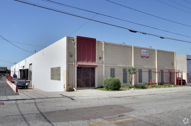
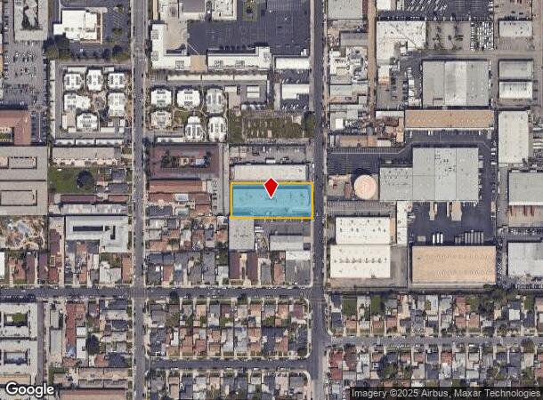
Property Record
13027 Yukon Ave, Hawthorne, CA 90250

Current Lease Availabilities
NEARBY LISTINGS FOR SALE OR LEASE
Property Detail
13027 Yukon Ave
Los Angeles-Long Beach-Glendale, CA
874
4050-014-039
TRACT NO 874, DIVISION A (EX OF ST) LOT 39
Lightindustrial
Los Angeles
X
California
06037C1790F
39
2024
0.88 AC
2025
Gardena/Hawthorne
602403
Los Angeles
17,664 SF
DEMOGRAPHICS near 13027 Yukon Ave
1 Mile
3 Mile
5 Mile
2024 Total Population
53,671
309,027
744,091
2029 Population
52,403
299,013
721,181
Pop Growth 2024-2029
(2.36%)
(3.24%)
(3.08%)
Average Age
36
38
39
2024 Total Households
18,449
101,361
248,400
HH Growth 2024-2029
(2.51%)
(3.46%)
(3.25%)
Median Household Inc
$58,665
$69,978
$75,324
Avg Household Size
2.80
3.00
2.90
2024 Avg HH Vehicles
2.00
2.00
2.00
Median Home Value
$707,996
$725,252
$786,271
Median Year Built
1970
1959
1960
Nearby Places
Map Layers
Map Styles
 Street
 Aerial
- Restaurants
- Banks
- Shops
- Fitness
- Groceries
PUBLIC TRANSPORTATION
AIRPORT
Los Angeles International
DRIVE
WALK
Distance
Los Angeles International
13 min
6.7 mi
Long Beach (Daugherty Field)
DRIVE
WALK
Distance
Long Beach (Daugherty Field)
24 min
15.6 mi
Bob Hope
DRIVE
WALK
Distance
Bob Hope
41 min
30.2 mi
Freight Ports
Port of Long Beach
DRIVE
WALK
Distance
Port of Long Beach
26 min
17.5 mi
Nearby Properties
Address
Land Use
TOTAL SIZE
Lot Size
Zoning
Address
Land Use
TOTAL SIZE
Lot Size
Zoning
584,746 SF
20.38 AC
MNIP
Address
Land Use
TOTAL SIZE
Lot Size
Zoning
Address
Land Use
TOTAL SIZE
Lot Size
Zoning
Address
Land Use
TOTAL SIZE
Lot Size
Zoning
Address
Land Use
TOTAL SIZE
Lot Size
Zoning
Address
Land Use
TOTAL SIZE
Lot Size
Zoning
337,106 SF
9.56 AC
ESCM*
Address
Land Use
TOTAL SIZE
Lot Size
Zoning
724,715 SF
5.76 AC
INCR*
Address
Land Use
TOTAL SIZE
Lot Size
Zoning
944,791 SF
22.53 AC
ESCM*
Address
Land Use
TOTAL SIZE
Lot Size
Zoning
421,934 SF
8.24 AC
ESCM
Address
Land Use
TOTAL SIZE
Lot Size
Zoning
718,086 SF
41.24 AC
RBI-1A
Address
Land Use
TOTAL SIZE
Lot Size
Zoning
418,131 SF
3.03 AC
LCC1
Address
Land Use
TOTAL SIZE
Lot Size
Zoning
848,217 SF
36.09 AC
RBI-1A
Address
Land Use
TOTAL SIZE
Lot Size
Zoning
189,244 SF
3.64 AC
ESCM*
Address
Land Use
TOTAL SIZE
Lot Size
Zoning
227,596 SF
14.38 AC
HAM1YY
Address
Land Use
TOTAL SIZE
Lot Size
Zoning
279,694 SF
3.19 AC
LCR1*
Address
Land Use
TOTAL SIZE
Lot Size
Zoning
354,673 SF
4.99 AC
ESCM*
Address
Land Use
TOTAL SIZE
Lot Size
Zoning
216,354 SF
3.52 AC
HAC3
Address
Land Use
TOTAL SIZE
Lot Size
Zoning
112,014 SF
5.11 AC
ESM2YY
Address
Land Use
TOTAL SIZE
Lot Size
Zoning
214,782 SF
3.66 AC
GAR3
Address
Land Use
TOTAL SIZE
Lot Size
Zoning
833,484 SF
6.62 AC
ESM2YY
Address
Land Use
TOTAL SIZE
Lot Size
Zoning
662,081 SF
2.50 AC
LAC2
Address
Land Use
TOTAL SIZE
Lot Size
Zoning
239,992 SF
4.72 AC
RBI-1B
Address
Land Use
TOTAL SIZE
Lot Size
Zoning
654,405 SF
14.82 AC
LAM2
Address
Land Use
TOTAL SIZE
Lot Size
Zoning
181,213 SF
3.96 AC
INCR*
Address
Land Use
TOTAL SIZE
Lot Size
Zoning
273,825 SF
7.73 AC
INRM*
Address
Land Use
TOTAL SIZE
Lot Size
Zoning
411,131 SF
11.41 AC
ESM2
Address
Land Use
TOTAL SIZE
Lot Size
Zoning
113,606 SF
4.03 AC
ESCM*
Address
Land Use
TOTAL SIZE
Lot Size
Zoning
92,374 SF
2.59 AC
ESCM*
Address
Land Use
TOTAL SIZE
Lot Size
Zoning
116,737 SF
6.13 AC
ESCM
The World's #1 Commercial Real Estate Marketplace
Connect with us
© 2025 CoStar Group
The information above has been obtained from sources believed reliable. While we do not doubt its accuracy we have not verified it and make no guarantee, warranty or representation about it. It is your responsibility to independently confirm its accuracy and completeness. Any projections, opinions, assumptions, or estimates used are for example only and do not represent the current or future performance of the property. The value of this transaction to you depends on tax and other factors which should be evaluated by your tax, financial, and legal advisors. You and your advisors should conduct a careful, independent investigation of the property to determine to your satisfaction the suitability of the property for your needs.