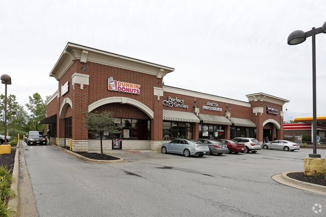
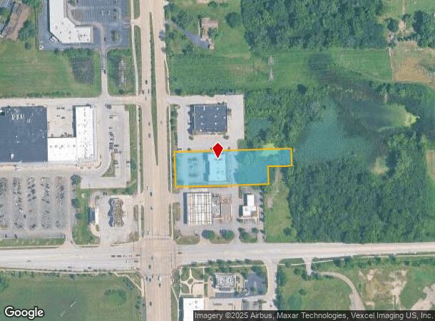
Property Record
13029 S La Grange Rd, Palos Park, IL 60464

Current Lease Availabilities
NEARBY LISTINGS FOR SALE OR LEASE
Property Detail
13029 S La Grange Rd
23-34-100-072-0000
Icds Resubdivision
Commercialbuilding
Cook
X
Illinois
17031C0613K
1.35 AC
2023
South Route 45
2024
Chicago
823901
Chicago-Naperville-Elgin, IL-IN-WI
7,700 SF
DEMOGRAPHICS near 13029 S La Grange Rd
1 Mile
3 Mile
5 Mile
2024 Total Population
3,901
46,585
148,351
2029 Population
3,732
45,035
144,168
Pop Growth 2024-2029
(4.33%)
(3.33%)
(2.82%)
Average Age
52
45
43
2024 Total Households
1,725
17,972
57,002
HH Growth 2024-2029
(5.04%)
(3.71%)
(3.14%)
Median Household Inc
$94,302
$96,219
$86,516
Avg Household Size
2.20
2.50
2.50
2024 Avg HH Vehicles
2.00
2.00
2.00
Median Home Value
$407,889
$328,776
$290,793
Median Year Built
1984
1979
1979
Nearby Places
- Restaurants
- Banks
- Shops
- Fitness
- Groceries
PUBLIC TRANSPORTATION
COMMUTER RAIL
Orland Park 143Rd (Southwest Service - Metra)
DRIVE
WALK
Distance
Orland Park 143Rd (Southwest Service - Metra)
4 min
1.9 mi
Palos Park Station (SouthWest Service - Northeast Illinois Regional Commuter Railroad (Metra))
DRIVE
WALK
Distance
Palos Park Station (SouthWest Service - Northeast Illinois Regional Commuter Railroad (Metra))
6 min
2.8 mi
AIRPORT
Chicago Midway International
DRIVE
WALK
Distance
Chicago Midway International
21 min
14.9 mi
Chicago O'Hare International
DRIVE
WALK
Distance
Chicago O'Hare International
41 min
25.4 mi
Freight Ports
Port Milwaukee
DRIVE
WALK
Distance
Port Milwaukee
123 min
102.1 mi
Nearby Properties
Address
Land Use
TOTAL SIZE
Lot Size
Zoning
Address
Land Use
TOTAL SIZE
Lot Size
Zoning
673,462 SF
41.34 AC
Address
Land Use
TOTAL SIZE
Lot Size
Zoning
535,443 SF
Address
Land Use
TOTAL SIZE
Lot Size
Zoning
188,930 SF
9.40 AC
Address
Land Use
TOTAL SIZE
Lot Size
Zoning
Address
Land Use
TOTAL SIZE
Lot Size
Zoning
103,110 SF
9.12 AC
Address
Land Use
TOTAL SIZE
Lot Size
Zoning
3,955 SF
1.82 AC
Address
Land Use
TOTAL SIZE
Lot Size
Zoning
367,687 SF
6.63 AC
Address
Land Use
TOTAL SIZE
Lot Size
Zoning
96,469 SF
6.77 AC
Address
Land Use
TOTAL SIZE
Lot Size
Zoning
104,589 SF
3.41 AC
Address
Land Use
TOTAL SIZE
Lot Size
Zoning
454,002 SF
10.50 AC
Address
Land Use
TOTAL SIZE
Lot Size
Zoning
94,932 SF
8.02 AC
Address
Land Use
TOTAL SIZE
Lot Size
Zoning
160,014 SF
13.04 AC
Address
Land Use
TOTAL SIZE
Lot Size
Zoning
24,600 SF
Address
Land Use
TOTAL SIZE
Lot Size
Zoning
104,427 SF
10.83 AC
Address
Land Use
TOTAL SIZE
Lot Size
Zoning
75,720 SF
7.50 AC
Address
Land Use
TOTAL SIZE
Lot Size
Zoning
176,762 SF
6.43 AC
Address
Land Use
TOTAL SIZE
Lot Size
Zoning
132,808 SF
15.97 AC
Address
Land Use
TOTAL SIZE
Lot Size
Zoning
74,992 SF
3.62 AC
Address
Land Use
TOTAL SIZE
Lot Size
Zoning
62,189 SF
7.56 AC
Address
Land Use
TOTAL SIZE
Lot Size
Zoning
50,151 SF
2.85 AC
Address
Land Use
TOTAL SIZE
Lot Size
Zoning
48,842 SF
5.84 AC
Address
Land Use
TOTAL SIZE
Lot Size
Zoning
202,591 SF
16.29 AC
Address
Land Use
TOTAL SIZE
Lot Size
Zoning
229,805 SF
16.04 AC
Address
Land Use
TOTAL SIZE
Lot Size
Zoning
Address
Land Use
TOTAL SIZE
Lot Size
Zoning
Address
Land Use
TOTAL SIZE
Lot Size
Zoning
53,649 SF
5.92 AC
Address
Land Use
TOTAL SIZE
Lot Size
Zoning
44,392 SF
4.23 AC
Address
Land Use
TOTAL SIZE
Lot Size
Zoning
97,583 SF
Address
Land Use
TOTAL SIZE
Lot Size
Zoning
55,617 SF
0.50 AC
Address
Land Use
TOTAL SIZE
Lot Size
Zoning
133,472 SF
17.24 AC
The World's #1 Commercial Real Estate Marketplace
Connect with us
© 2025 CoStar Group
The information above has been obtained from sources believed reliable. While we do not doubt its accuracy we have not verified it and make no guarantee, warranty or representation about it. It is your responsibility to independently confirm its accuracy and completeness. Any projections, opinions, assumptions, or estimates used are for example only and do not represent the current or future performance of the property. The value of this transaction to you depends on tax and other factors which should be evaluated by your tax, financial, and legal advisors. You and your advisors should conduct a careful, independent investigation of the property to determine to your satisfaction the suitability of the property for your needs.